Prince William County, Virginia
| Prince William County, Virginia | |||
|---|---|---|---|
| County | |||
| Prince William County | |||
|
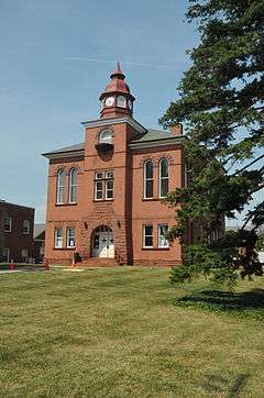
The Prince William County Courthouse in Manassas in July 2011 | |||
| |||
| Nickname(s): "P.W. County" | |||
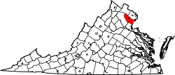 Location in the U.S. state of Virginia | |||
 Virginia's location in the U.S. | |||
| Founded | 1731 | ||
| Named for | Prince William, Duke of Cumberland | ||
| Seat | Manassas | ||
| Largest town | Dumfries | ||
| Area | |||
| • Total | 348 sq mi (901 km2) | ||
| • Land | 336 sq mi (870 km2) | ||
| • Water | 12 sq mi (31 km2), 3.5% | ||
| Population (est.) | |||
| • (2015) | 451,721 | ||
| • Density | 1,298/sq mi (501/km²) | ||
| Congressional districts | 1st, 10th, 11th | ||
| Time zone | Eastern: UTC-5/-4 | ||
| Website |
www | ||
Prince William County is located on the Potomac River in the Commonwealth of Virginia. As of the 2010 census, the population was 402,002,[1] in 2014, the population was estimated to be 437,636,[2] making it the second-most populous county in Virginia. Its county seat is the independent city of Manassas.[3]
A part of Northern Virginia, Prince William County is included in the Washington-Arlington-Alexandria, DC-VA-MD-WV Metropolitan Statistical Area. In 2012 it had the seventh highest income of any county in the United States. It was the first majority-minority county in Virginia, with Hispanic (of any race, mostly from Central and South America), African American, and Asian being the chief groups.[4]
The Bureau of Economic Analysis combines the independent cities of Manassas and Manassas Park with Prince William County (within which the two cities are enclaves) for statistical purposes:
| Name | Area (km²) | Population 2000 Census | Population 2010 Census | Population 1 July 2013 Estimate |
|---|---|---|---|---|
| Manassas (city) | 25.59 | 35,135 | 37,821 | 41,705 |
| Manassas Park (city) | 6.55 | 10,290 | 14,273 | 16,149 |
| Prince William County | 871.27 | 280,813 | 402,002 | 438,580 |
| Totals | 903.41 | 326,238 | 454,096 | 486,434 |
History
At the time of European encounter, the inhabitants of the area that would become Prince William County were the Doeg, an Algonquian-speaking sub-group of the Powhatan tribal confederation. When John Smith and other English explorers ventured to the upper Potomac River beginning in 1608, they recorded the name of a village the Doeg inhabited as Pemacocack (meaning "plenty of fish"). It was located on the west bank of the Potomac River about 30 miles south of present-day Alexandria.[5] The Doeg maintained several villages in this area into the 1650s, when colonists began to patent the land.
Prince William County was created by an act of the General Assembly of the colony of Virginia in 1731; it was organized largely from the western section of Stafford County as well as a section of King George County.[6] The area encompassed by the act creating Prince William County originally included all of what later became the counties of Arlington, Fairfax, Fauquier, and Loudoun; and the independent cities of Alexandria, Fairfax, Falls Church, Manassas, and Manassas Park. These later became independent jurisdictions. The county was named for Prince William, Duke of Cumberland, the third son of King George II.[7]
In 1790 the population of the county was 58% white; most of the remainder was black and enslaved. The county had been an area of tobacco plantations, where crops were being changed to mixed crops due to soil exhaustion and changes in the market. In the first two decades after the Revolution, the number and percentage of free blacks increased in Virginia as some whites freed their slaves, based on revolutionary ideals. Most free people of color in the state were descended from colonial unions between white women and African-American men, slave, indentured servant or free. Under colonial law since 1662, children took the status of their mother, so children born to white women were free, even if of mixed race.[8]
The county was rural and agricultural for decades. The population into the early 20th century was centered in two areas, one at Manassas (home to a major railroad junction), the other near Occoquan and Woodbridge along the Potomac River. Beginning in the late 1930s, a larger suburban population was attracted to new housing that was developed near the existing population centers, particularly in Manassas.
In 1960 the population was 50,164, but suburbanization caused that to increase rapidly in the following decades, supported by expansion of federal, military and commercial activities in Northern Virginia in the late 20th century. By 2000, this was the third-most populous local jurisdiction in Virginia. From 2000 to 2010, the population increased by 43.2%. This was the first county in Virginia to be minority-majority: the new majority is composed of Hispanic (of any race, largely of Central and South American ancestry), African American, and Asian.[9] In 2012 it was the seventh-wealthiest county in the country.[4] The estimated population of 2014 is more than 437,000.
The Marine Corps Heritage Museum and the Hylton Performing Arts Center opened in the 21st century. The American Wartime Museum is also to be located in this county. During the commemoration of the Sesquicentennial of the Civil War, re-enactment of the famous First and Second Battles of Manassas was planned.
Geography
According to the U.S. Census Bureau, the county has a total area of 348 square miles (900 km2), of which 336 square miles (870 km2) is land and 12 square miles (31 km2) (3.5%) is water.[10] It is bounded on the north by Loudoun and Fairfax Counties; on the west by Fauquier County; on the south by Stafford County; and on the east by the Potomac River (Charles County, Maryland lies across the river).
Adjacent jurisdictions
- Loudoun County, Virginia - North
- Fairfax County, Virginia - Northeast
- Charles County, Maryland - Southeast
- Stafford County, Virginia - South
- Fauquier County, Virginia - West
- Manassas, Virginia - Center (enclave)
- Manassas Park, Virginia - Center (enclave)
National protected areas
- Featherstone National Wildlife Refuge
- Manassas National Battlefield Park
- Occoquan Bay National Wildlife Refuge
- Prince William Forest Park
Government
Local
The county is divided into seven magisterial districts: Brentsville, Coles, Potomac, Gainesville, Neabsco, Occoquan, and Woodbridge. The magisterial districts each elect one supervisor to the Board of Supervisors which governs Prince William County. There is also a chairman elected by the county at-large, bringing total board membership to 8. A vice-chairman is selected by the board from among its membership. The current Chairman is Corey A. Stewart, who previously served as the Occoquan District Supervisor. The current Vice-Chairman is Maureen S. Caddigan, the Potomac District Supervisor. The county operates under the county form of the county executive system of government, with an elected Board of Supervisors. The board appoints a professional, nonpartisan county executive to manage operations of government agencies.
Republicans hold six of the eight seats on the Board of Supervisors as well as the offices of County Sheriff and Clerk of the Court. No Democrat has chaired the Board of County Supervisors since Kathleen Seefeldt left office in January 2000.
In other elected local offices, the Prince William County Commonwealth's Attorney, Paul Ebert, is a Democrat. The Sheriff, Glen Hill, is a Republican, as is the Clerk of the Circuit Court, Michèle McQuigg.
In 2006, the then-Chairman of the Board of Supervisors, Sean Connaughton, was appointed as head of the U.S. Maritime Administration by President George W. Bush. A special election to fill the vacancy was called for the same day as the U.S. Senate election between Jim Webb and George F. Allen. Occoquan District Supervisor Corey Stewart won the election and a special election was called for January 2007 to fill the vacancy in the Occoquan District. Stewart's successor for the Occoquan District was Michael C. May, a fellow Republican.
State offices
Republicans hold six of the eight Virginia House of Delegates seats that include parts of the county. Republican delegates include Robert G. Marshall, Scott Lingamfelter, Tim Hugo, Jackson Miller, Rich Anderson, and David Ramadan. Luke Torian and Michael Futrell are the Democratic members of the House. The three of five Virginia State Senate seats that include parts of the county are held by Democrats, including Democratic Sen. Charles Colgan, the President pro tempore of the Senate, Toddy Puller and George Barker. Republicans Richard Stuart and Dick Black (politician) also represent portions of the county.
In 2005, Democratic Gubernatorial candidate Timothy M. Kaine won the county with 49.95% of the vote.
National politics
Republicans hold two of the three U.S. Congressional seats (VA-1 and VA-10) that include parts of Prince William County. In 2006, Democratic U.S. Senator candidate Jim Webb carried the county with 50.51% of the vote.
In the United States presidential election, 2008, Democrat Barack Obama carried Prince William with 57.51% of the vote, compared to Republican John McCain who received 41.62%. Obama's final rally the night before the election was held at the Prince William County Fairgrounds, just outside the city of Manassas.[11]
Continuing demographic changes in the county, such as an increasingly diverse and urbanized population, were cited by The New York Times as contributing to Obama's success in the United States presidential election, 2012 and suggesting the future appeal of the Democratic Party in the United States. Between 2000 and 2010, county population had increased by 121,189 persons (43.2%).[9] It had changed from a primarily white, rural county. Prince William by 2012 had an educated professional population with the seventh-highest income in the country; it is the first county in Virginia to be composed of a majority of minorities: Hispanic, African American, and Asian. Obama and the Democrats attracted their votes.[4] Time identified Prince William as one of five critical counties in Virginia for the election. Obama defeated Romney soundly by 15 percentage points with a margin of 57%-42%.[12]
| Name | Party | First Election | District | |
|---|---|---|---|---|
| Corey Stewart, Chairman | Rep | 2003 | At-Large | |
| Jeanine Lawson | Rep | 2015 | Brentsville | |
| Martin E. Nohe | Rep | 2003 | Coles | |
| Peter Candland | Rep | 2011 | Gainesville | |
| John D. Jenkins | Dem | 1982 | Neabsco | |
| Michael C. May | Rep | 2007 | Occoquan | |
| Maureen S. Caddigan | Rep | 1995 | Potomac | |
| Frank J. Principi | Dem | 2007 | Woodbridge | |
| Position | Name | Party | First Election | |
|---|---|---|---|---|
| Sheriff | Glendell Hill | Rep | 2004 | |
| Commonwealth's Attorney | Paul B. Ebert | Dem | 1968 | |
| Clerk of Circuit Court | Michèle McQuigg | Rep | 2008 | |
| Name | Party | First Election | District | |
|---|---|---|---|---|
| Michael Futrell | Dem | 2013 | 2 | |
| Bob Marshall | Rep | 1991 | 13 | |
| Scott Lingamfelter | Rep | 2001 | 31 | |
| Tim Hugo | Rep | 2001 | 40 | |
| Jackson Miller | Rep | 2006 | 50 | |
| Richard Anderson | Rep | 2009 | 51 | |
| Luke Torian | Dem | 2009 | 52 | |
| David Ramadan | Rep | 2011 | 87 | |
| Name | Party | First Election | District | |
|---|---|---|---|---|
| Richard "Dick" Black | Rep | 2011 | 13 | |
| Richard Stuart | Rep | 2007 | 28 | |
| Chuck Colgan | Dem | 1975 | 29 | |
| Toddy Puller | Dem | 2000 | 36 | |
| George Barker | Dem | 2007 | 39 | |
Economy
Top employers
According to the County's 2013 Comprehensive Annual Financial Report,[13] the top employers in the county are:
| # | Employer | # of Employees |
|---|---|---|
| 1 | Prince William County Public Schools | 1,000 and over |
| 2 | U.S. Department of Defense | 1,000 and over |
| 3 | County of Prince William | 1,000 and over |
| 4 | Walmart | 1,000 and over |
| 5 | Morale, Welfare and Recreation | 1,000 and over |
| 6 | Sentara Healthcare/Potomac Hospital Corporation | 1,000 and over |
| 7 | Wegmans Food Markets | 500 to 999 |
| 8 | Minnieland Private Day School | 500 to 999 |
| 9 | Northern Virginia Community College | 500 to 999 |
| 10 | Target Corporation | 500 to 999 |
Education
Public schools
Prince William County Public Schools is the second largest school system in Virginia (having recently overtaken Virginia Beach City Public Schools).[14] The system consists of 57 elementary, 16 middle, and 12 high schools, as well as a virtual high school, two traditional schools, three special education schools, and two alternative schools. The Superintendent of Prince William County Public Schools is Dr. Steven L. Walts.
The system has a television station called PWCS-TV. It is programmed and operated by Prince William County Public Schools' Media Production Services Department and is accessible to Comcast and Verizon subscribers in Prince William County.
Colleges
Universities
- George Mason University
- Stratford University
- Strayer University
- University of Northern Virginia
- National University
Demographics
| Historical population | |||
|---|---|---|---|
| Census | Pop. | %± | |
| 1790 | 11,615 | — | |
| 1800 | 12,733 | 9.6% | |
| 1810 | 11,311 | −11.2% | |
| 1820 | 9,419 | −16.7% | |
| 1830 | 9,330 | −0.9% | |
| 1840 | 8,144 | −12.7% | |
| 1850 | 8,129 | −0.2% | |
| 1860 | 8,565 | 5.4% | |
| 1870 | 7,504 | −12.4% | |
| 1880 | 9,180 | 22.3% | |
| 1890 | 9,805 | 6.8% | |
| 1900 | 11,112 | 13.3% | |
| 1910 | 12,026 | 8.2% | |
| 1920 | 13,660 | 13.6% | |
| 1930 | 13,951 | 2.1% | |
| 1940 | 17,738 | 27.1% | |
| 1950 | 22,612 | 27.5% | |
| 1960 | 50,164 | 121.8% | |
| 1970 | 111,102 | 121.5% | |
| 1980 | 144,636 | 30.2% | |
| 1990 | 215,686 | 49.1% | |
| 2000 | 280,813 | 30.2% | |
| 2010 | 402,002 | 43.2% | |
| Est. 2015 | 451,721 | [15] | 12.4% |
| U.S. Decennial Census[16] 1790-1960[17] 1900-1990[18] 1990-2000[19] | |||
As of the census[20] of 2010, there were 402,002 people, 137,115 housing units, and 130,785 households residing in the county. The population density was 1,186 people per square mile (458/km²). There were 137,115 housing units at an average density of 405 per square mile (156/km²). The racial makeup of the county (reporting as only one race) was:
- 57.8% White
- 20.2% Black or African American
- 0.6% Native American
- 7.5% Asian (1.5% Indian, 1.2% Filipino, 1.2% Korean, 0.8% Vietnamese 0.6% Chinese, 0.1% Japanese, 2.1% Other Asian)
- 0.1% Pacific Islander
- 9.1% from other races
- and 5.1% from two or more races
- 20.3% of the population was Hispanic or Latino of any race (6.8% Salvadoran, 3.7% Mexican, 1.8% Puerto Rican, 1.1% Guatemalan, 1.0% Peruvian, 0.9% Honduran, 0.7% Bolivian, 0.4% Colombian, 0.3% Nicaraguan, 0.3% Dominican)
Also according to census figures, there were 130,785 households in Prince William County as of April 1, 2010. According to the Census Bureau’s 2009 American Community Survey,[21] 76.1% of the County’s households are occupied by families, (compared to 66.5% in the United States). This represents a decrease of 4.6 percentage points since 1990, when 80.7% of households in the County were families. Approximately 42.2% of Prince William County’s households are family households occupied by parents with their own children under 18 years of age.
According to the Census Bureau’s 2009 American Community Survey, 29.3% of the total County population is under 18 years of age; approximately 6.5% is aged 65 and over. The median age of the population is 33.2 years. The 2009 American Community Survey also indicated that 50.0% of the County’s population is male and 50.0% is female.
According to the 2009 American Community Survey, the 2009 median household income in Prince William County was $89,785. The per capita income for the county was $35,890. The 2009 American Community Survey reported that in 2009, 6.0% of Prince William County’s population was living below the poverty line, including 7.7% of those under age 18 and 5.3% of those age 65 or over.
Sports
The Potomac Nationals are a Minor League Baseball team located in Woodbridge, Virginia. The Nationals play in the high-A Carolina League and are an affiliate of the Washington Nationals. The Northern Virginia Royals are an American minor league soccer team, also located in Woodbridge, Virginia. The Royals have minor league affiliation with D.C. United, Washington, DC Major League Soccer franchise.
The historic Old Dominion Speedway was located in Manassas. Opened in 1948, it was the location of the first commercial drag race held on the East Coast. It was also a stop on the NASCAR Grand National (now the Sprint Cup Series) schedule in the late 50's and early 60's. Old Dominion Speedway closed in the Fall of 2012. Being hemmed in by residential development led to frequent noise complaints from neighbors, which convinced ownership to search for new locations along 95 between Stafford County and Richmond.
Steve Britt, principal owner of the Old Dominion Speedway, is under contract to purchase land just north of Mudd Tavern Road from a man who lives outside the Fredericksburg area. The sale is contingent on various government approvals, including a rezoning and special-use permit from Spotsylvania County.
The new facility will be called the Dominion Raceway and will be easily visible from I–95. The main entrance will be off Mudd Tavern Road near the northbound ramp onto 95.[22]
Museums
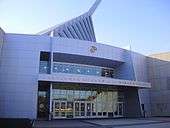
The National Museum of the Marine Corps is located in Triangle, Virginia and is free to the public. The Historic Preservation Division of Prince William County also operates five museums: Rippon Lodge Historic Site, Brentsville Historic Centre, Bristoe Station Battlefield Heritage Park, Lucasville Historic Site, and Ben Lomond Historic Site.
Libraries
The Prince William Public Library System is a regional public library system that serves Prince William County, the City of Manassas and the City of Manassas Park. The system consists of 6 full-service branches and 5 neighborhood branches that covers the entire Prince William area.
Parks
Two National Parks lie within the county. Prince William Forest Park was established as Chopawamsic Recreational Demonstration Area in 1936 and is located in eastern Prince William County. This is the largest protected natural area in the Washington, D.C. metropolitan region at over 15,000 acres (6,070 ha). Manassas National Battlefield Park, located north of Manassas in Prince William County, preserves the site of two major American Civil War battles: the First Battle of Manassas on July 21, 1861, and the Second Battle of Manassas which was fought between August 28 and August 30, 1862. Outside the South, these battles are commonly referred to as the first and second battles of Bull Run.
The Prince William County Department of Parks & Recreation operates fifty parks, two water parks, two recreation centers (Birchdale Rec. Center and Sharron Baucom Dale City Rec. Center), two community centers, six sports complexes, and an ice skating rink.
- Prince William Forest Park, the largest National Park Service property in the Washington, D.C. metropolitan area
- Leesylvania State Park, the ancestral home of the Lee family, with a range of recreational activities and views of the river
- Manassas National Battlefield Park, a Civil War battlefield
Transportation
The county is traversed by many major highways and roads, including the following:
 Interstate 66
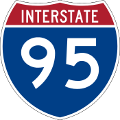 Interstate 95
 U.S. Route 1
 U.S. Route 15
 U.S. Route 29
 State Route 28
 State Route 123
 State Route 234
 Prince William Parkway
Manassas Regional Airport lies near its namesake city; for commercial passengers, both Dulles Airport and Ronald Reagan Washington National Airport are located nearby.
Public busing in the county is provided by the Potomac and Rappahannock Transportation Commission. Services provided by PRTC include OmniRide, OmniLink, and OmniMatch.
The county is served by both Virginia Railway Express (VRE) lines. The Manassas line has the Manassas Park, Manassas, and Broad Run / Airport stations. The Fredericksburg line has the Woodbridge, Rippon, and Quantico stations.[23] The Manassas, Quantico and Woodbridge stations are also served by Amtrak.
Communities
Towns
Unincorporated communities
- Aden
- Antioch
- Bethel
- Brentsville
- Bristow
- Buckhall
- Buckland
- Bull Run
- Canova
- Catharpin
- Cherry Hill
- Cornwell
- Dale City
- Featherstone
- Gainesville
- Greenwich
- Hoadly
- Independent Hill
- Lake Ridge
- Linton Hall
- Loch Lomond
- Marumsco
- Montclair
- Neabsco
- Nokesville
- Quantico Station
- Rixlew
- Southbridge
- Sudley
- Sudley Springs
- Thoroughfare
- Triangle
- Waterfall
- Wellington
- West Gate
- Woodbridge
- Yorkshire
Former communities
|
|
Independent cities
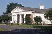
The independent cities of Manassas and Manassas Park are surrounded by Prince William County. Before becoming independent cities in 1975, as are all cities in Virginia, both were towns and officially part of the county. The Prince William County Circuit, District, Juvenile and Domestic Relations Courts, Prince William County Commonwealth Attorney's Office, Prince William County Adult Detention Center, Prince William County Sheriff's Office, and other county agencies are located at Prince William County Courthouse complex. The courthouse complex itself is located in a Prince William County enclave surrounded by the city of Manassas.
Prince William County, Manassas, and Manassas Park share a single judicial system (courts) and Constitutional offices (Commonwealth's Attorney, Sheriff, Circuit Court Clerk).
Other important features
- Marine Corps Base Quantico, a large military installation
- Hylton Performing Arts Center
- Jiffy Lube Live, a large concert venue
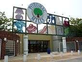
- Potomac Mills, the 10th most popular tourist destination in Virginia and largest outlet mall in the region
- FBI Academy, the Federal Bureau of Investigation's training and research facility.
See also
- National Register of Historic Places listings in Prince William County, Virginia
- Prince William Chamber of Commerce
- Prince William County Police Department
- Prince William County Sheriff's Office
- Prince William Public Library System
- Prince William County Department of Fire and Rescue
- Splash Down Waterpark
References
- ↑ "State & County QuickFacts". United States Census Bureau. Retrieved January 4, 2014.
- ↑ . Virginia State 2014 Population Estimates Retrieved February 5, 2015
- ↑ "Find a County". National Association of Counties. Retrieved 2011-06-07.
- 1 2 3 Michael D. Shear (November 7, 2012). "Demographic Shift Brings New Worry for Republicans". The New York Times. Retrieved November 8, 2012.
- ↑ Swanton, John R. (1952), The Indian Tribes of North America, Smithsonian Institution, p. 69, ISBN 0-8063-1730-2, OCLC 52230544
- ↑ "Legislation creating Prince William County, Virginia". Historic Prince William. Retrieved 2008-09-20.
- ↑ "Commemorating the 275th anniversary of Prince William County, Virginia". Sunlight Foundation. Retrieved 5 May 2012.
- ↑ Paul Heinegg, Free African Americans of Virginia, North Carolina, South Carolina, Maryland and Delaware, 1995-2005
- 1 2 "Demographic and Economic Newsletter", Prince William Report, Second Quarter 2014, April–June 2014
- ↑ "US Gazetteer files: 2010, 2000, and 1990". United States Census Bureau. 2011-02-12. Retrieved 2011-04-23.
- ↑ Kiser, Uriah (November 1, 2008). "Thousands gathering for Obama's final rally". insidenova.com. Retrieved February 18, 2010.
- ↑ "The White House - Obama's Path to Victory", Time, pp. 16–17, November 19, 2012
- ↑ "Comprehensive Annual Financial Report for the Fiscal Year Ended June 30, 2013" (PDF). County of Prince William, Virginia.
- ↑ "Northern Virginia rises to dominance". The Virginian-Pilot. Norfolk, Virginia. December 31, 2007. Retrieved September 20, 2008.
- ↑ "County Totals Dataset: Population, Population Change and Estimated Components of Population Change: April 1, 2010 to July 1, 2015". Retrieved July 2, 2016.
- ↑ "U.S. Decennial Census". United States Census Bureau. Retrieved January 2, 2014.
- ↑ "Historical Census Browser". University of Virginia Library. Retrieved January 2, 2014.
- ↑ "Population of Counties by Decennial Census: 1900 to 1990". United States Census Bureau. Retrieved January 2, 2014.
- ↑ "Census 2000 PHC-T-4. Ranking Tables for Counties: 1990 and 2000" (PDF). United States Census Bureau. Retrieved January 2, 2014.
- ↑ "American FactFinder". United States Census Bureau. Retrieved 2011-05-14.
- ↑ American Community Survey, US Census Bureau
- ↑ Old Dominion Speedway plans to relocate to Spotsylvania County - Business Insider
- ↑ Station Map, Virginia Railway Express (VRE), retrieved August 9, 2009
External links
| Wikimedia Commons has media related to Prince William County, Virginia. |
-
 Prince William County travel guide from Wikivoyage
 - Official website
- Prince William County at the Wayback Machine (archived June 7, 2012)
- Prince William County at the Wayback Machine (archived April 12, 1997)
 |
Loudoun County | Fairfax County | | |
| Fauquier County | |
|||
| ||||
| | ||||
| Stafford County | Charles County, Maryland |
| Administration |
|  | |||||
|---|---|---|---|---|---|---|---|
| Organizations | |||||||
| Landmarks | |||||||
| Transportation | |||||||
| Culture |
| ||||||
| Education | |||||||
Municipalities and communities of Prince William County, Virginia, United States | ||
|---|---|---|
| Towns | | |
| CDPs | ||
| Unincorporated communities | ||
| Footnotes | ‡This populated place also has portions in an adjacent county or counties | |
| Principal cities |
| |||||||||||
|---|---|---|---|---|---|---|---|---|---|---|---|---|
| Counties and county equivalents* |
| |||||||||||
The District of Columbia itself, and Virginia's incorporated cities, are county equivalents. Virginia's incorporated cities are listed under their surrounding county. The incorporated cities bordering more than one county (Alexandria, Falls Church and Fredericksburg) are listed under the county they were part of before incorporation as a city. | ||||||||||||
Coordinates: 38°42′N 77°29′W / 38.70°N 77.48°W