Portsmouth, Virginia
| Portsmouth, Virginia | |
|---|---|
| Independent city | |
|
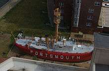
Downtown Portsmouth | |
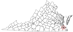 Location in the Commonwealth of Virginia | |
 Portsmouth, Virginia Location in the United States | |
| Coordinates: 36°49′59″N 76°17′50″W / 36.832994°N 76.297230°WCoordinates: 36°49′59″N 76°17′50″W / 36.832994°N 76.297230°W | |
| Country |
|
| State |
|
| County | None (Independent city) |
| Founded | 1752 |
| Government | |
| • Mayor | Kenneth I. Wright |
| Area | |
| • Total | 120 km2 (47 sq mi) |
| • Land | 90 km2 (34 sq mi) |
| • Water | 30 km2 (13 sq mi) |
| Elevation | 6 m (20 ft) |
| Population (2010) | |
| • Total | 95,535 |
| • Density | 780/km2 (2,000/sq mi) |
| Time zone | EST (UTC-5) |
| • Summer (DST) | EDT (UTC-4) |
| Area code(s) | 757 |
| FIPS code | 51-64000[1] |
| GNIS feature ID | 1497102[2] |
| Website | http://www.portsmouthva.gov/ |
_up_the_Elizabeth_River%2C_past_Portsmouth_landmarks.jpg)
Portsmouth is an independent city located in the U.S. commonwealth of Virginia. As of the 2010 census, the population was 95,535.[3] It is part of the Hampton Roads metropolitan area.
The Norfolk Naval Shipyard, often called the Norfolk Navy Yard, is a historic and active U.S. Navy facility that is actually located in Portsmouth rather than Norfolk; the original name "Gosport" was changed to "Norfolk" to reflect its location in Norfolk County, VA. The shipyard upgrades, remodels, and repairs ships of the US Navy and is one of the few facilities in the world with the capability to dry dock an aircraft carrier.
Directly opposite Norfolk, the city of Portsmouth also has miles of waterfront land on the Elizabeth River as part of the harbor of Hampton Roads. There is a ferry boat that takes riders back and forth across the water between Downtown Norfolk and Olde Towne Portsmouth.
History
Portsmouth is located on the western side of the Elizabeth River directly across from the City of Norfolk. In 1620, the future site of Portsmouth was recognized as suitable shipbuilding location by John Wood, a shipbuilder, who petitioned King James I of England for a land grant. The surrounding area was soon settled as a plantation community.[4]

Portsmouth was founded by Colonel William Crawford, a member of the Virginia House of Burgesses.[5] It was established as a town in 1752 by an act of the Virginia General Assembly and was named for Portsmouth, England.[4]
In 1767, Andrew Sprowle, a shipbuilder, founded the Gosport Shipyard adjacent to Portsmouth. The Gosport Shipyard at Portsmouth was owned by the Commonwealth of Virginia after the American Revolutionary War and was sold to the new United States federal government.
In 1855, the Portsmouth and Norfolk area suffered an epidemic of yellow fever which killed 1 of every three citizens. It became an independent city from Norfolk County in 1858.
During the American Civil War, in 1861, Virginia joined the Confederate States of America. Fearing that the Confederacy would take control of the shipyard at Portsmouth, the shipyard commander ordered the burning of the shipyard. The Confederate forces did in fact take over the shipyard, and did so without armed conflict through an elaborate ruse orchestrated by civilian railroad builder William Mahone (soon to become a famous Confederate officer). The Union forces withdrew to Fort Monroe across Hampton Roads, which was the only land in the area which remained under Union control.
In early 1862, the Confederate ironclad warship CSS Virginia was rebuilt using the burned-out hulk of USS Merrimack. Virginia engaged the Union ironclad USS Monitor in the famous Battle of Hampton Roads during the Union blockade of Hampton Roads. The Confederates burned the shipyard again when they left in May 1862.
Following the recapture of Norfolk and Portsmouth by the Union forces, the name of the shipyard was changed to Norfolk Naval Shipyard. The name of the shipyard was derived from its location in Norfolk County. The Norfolk Naval Shipyard today is located entirely within the city limits of Portsmouth, Virginia. The Norfolk Naval Shipyard name has been retained to minimize any confusion with the Portsmouth Naval Shipyard, which itself is actually located in Kittery, Maine, across the Piscataqua River from Portsmouth, New Hampshire.
Portsmouth was the county seat of Norfolk County until 1963 when the new city of Chesapeake was formed in a political consolidation with the city of South Norfolk. Portsmouth's other county neighbor, the former Nansemond County, also consolidated with a smaller city, forming the new city of Suffolk in 1974.
One of the older cities of Hampton Roads, in the early 21st century, Portsmouth was undergoing moderate urban renewal in the downtown.
The APM "MAERSK" marine terminal for container ships opened in 2007 in the West Norfolk section.
Historic sites
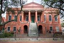
Olde Towne
The Olde Towne Historic District features one of the largest collections of historically significant homes between Alexandria, Virginia and Charleston, South Carolina.[6] The Emanuel African Methodist Episcopal Church was built by slaves and free men and is the second-oldest building in Portsmouth and the city's oldest black church.
The city contains a number of other historic buildings, as well, including the Pass House, which was built in 1841 by Judge James Murdaugh and occupied by Union troops from 1862 to 1865. Federal forces required Portsmouth residents to obtain a written pass to travel across the Elizabeth River and beyond. These passes were issued from the English basement and thus the name "Pass House" was derived.
Naval Medical Center Portsmouth
Formerly the Naval Hospital Portsmouth, the Naval Medical Center Portsmouth is a United States Navy medical center adjacent to the Olde Towne Historic District and Park View Historic District. Founded in 1827, it is the oldest continuously running hospital in the Navy medical system with the motto "First and Finest."[7]
Seaboard Coastline Building
Located at 1 High Street in the Olde Towne Historic District, the Seaboard Coastline Building is a historic train station and former headquarters of the Seaboard Air Line railroad company.
The Hill House
Four-story 1825 English basement home furnished entirely with original family belongings. It is evident from the furnishings that the Hill family were avid collectors and lived graciously over a period of 150 years. The house remains in its original condition, with limited renovation through the years.
Cedar Grove Cemetery
Established in 1832, Cedar Grove Cemetery is the oldest city-owned cemetery in Portsmouth. Listed on the National Register of Historic Places listings in Portsmouth, Virginia, the cemetery is noted for its funerary art and the civic, business, maritime, religious and military leaders who are buried there. Historical markers placed throughout the cemetery allow for self-guided tours. The cemetery is located between Effingham Street and Fort Lane in Olde Towne Portsmouth. Entrance is through the south gate to the cemetery, located on London Boulevard.
Geography

According to the United States Census Bureau, the city has a total area of 47 square miles (120 km2), of which 34 square miles (88 km2) is land and 13 square miles (34 km2) (28.0%) is water.[8]
Climate
Portsmouth's mild humid subtropical climate means outdoor activities can be enjoyed year round. The weather in Portsmouth is temperate and seasonal. Summers are hot and humid with warm evenings. The mean annual temperature is 65 °F (18 °C), with an average annual snowfall of 3 inches and an average annual rainfall of 47 inches. No measurable snow fell in 1999. The wettest seasons are the spring and summer, although rainfall is fairly constant all year round. The highest recorded temperature was 105.0 °F in 1980. The lowest recorded temperature was -3.0 °F on January 21, 1985.[9]
Additionally, the geographic location of the city, with respect to the principal storm tracks, is especially favorable, as it is south of the average path of storms originating in the higher latitudes, and north of the usual tracks of hurricanes and other major tropical storms.[10] Snow falls rarely, averaging 3 inches (76 mm) per season.[11]
| Climate data for Norfolk International Airport, Virginia (1981–2010 normals,[lower-alpha 1] extremes 1874–present[lower-alpha 2]) | |||||||||||||
|---|---|---|---|---|---|---|---|---|---|---|---|---|---|
| Month | Jan | Feb | Mar | Apr | May | Jun | Jul | Aug | Sep | Oct | Nov | Dec | Year |
| Record high °F (°C) | 84 (29) |
82 (28) |
92 (33) |
97 (36) |
100 (38) |
102 (39) |
105 (41) |
105 (41) |
100 (38) |
95 (35) |
86 (30) |
82 (28) |
105 (41) |
| Mean maximum °F (°C) | 71.1 (21.7) |
73.2 (22.9) |
80.2 (26.8) |
86.4 (30.2) |
91.4 (33) |
95.5 (35.3) |
97.8 (36.6) |
95.8 (35.4) |
92.1 (33.4) |
85.6 (29.8) |
78.7 (25.9) |
72.5 (22.5) |
98.8 (37.1) |
| Average high °F (°C) | 48.1 (8.9) |
50.9 (10.5) |
58.2 (14.6) |
67.6 (19.8) |
75.4 (24.1) |
83.5 (28.6) |
87.4 (30.8) |
85.1 (29.5) |
79.3 (26.3) |
70.1 (21.2) |
61.1 (16.2) |
52.1 (11.2) |
68.3 (20.2) |
| Average low °F (°C) | 32.7 (0.4) |
34.4 (1.3) |
40.5 (4.7) |
48.9 (9.4) |
57.9 (14.4) |
67.1 (19.5) |
71.9 (22.2) |
70.7 (21.5) |
65.3 (18.5) |
54.0 (12.2) |
44.6 (7) |
36.1 (2.3) |
52.1 (11.2) |
| Mean minimum °F (°C) | 17.6 (−8) |
21.2 (−6) |
27.2 (−2.7) |
35.7 (2.1) |
45.7 (7.6) |
55.5 (13.1) |
63.1 (17.3) |
61.6 (16.4) |
53.7 (12.1) |
39.7 (4.3) |
30.5 (−0.8) |
21.7 (−5.7) |
15.2 (−9.3) |
| Record low °F (°C) | −3 (−19) |
2 (−17) |
14 (−10) |
23 (−5) |
36 (2) |
45 (7) |
54 (12) |
49 (9) |
40 (4) |
27 (−3) |
17 (−8) |
5 (−15) |
−3 (−19) |
| Average precipitation inches (mm) | 3.40 (86.4) |
3.12 (79.2) |
3.68 (93.5) |
3.41 (86.6) |
3.41 (86.6) |
4.26 (108.2) |
5.14 (130.6) |
5.52 (140.2) |
4.76 (120.9) |
3.42 (86.9) |
3.15 (80) |
3.26 (82.8) |
46.53 (1,181.9) |
| Average snowfall inches (cm) | 2.4 (6.1) |
2.0 (5.1) |
0.2 (0.5) |
trace | 0 (0) |
0 (0) |
0 (0) |
0 (0) |
0 (0) |
0 (0) |
trace | 1.2 (3) |
5.8 (14.7) |
| Average precipitation days (≥ 0.01 in) | 10.4 | 9.5 | 10.6 | 10.1 | 10.6 | 9.9 | 11.1 | 10.1 | 8.8 | 7.6 | 8.5 | 9.8 | 117.0 |
| Average snowy days (≥ 0.1 in) | 1.6 | 1.3 | 0.4 | 0.1 | 0 | 0 | 0 | 0 | 0 | 0 | 0 | 0.6 | 4.0 |
| Average relative humidity (%) | 66.3 | 65.6 | 64.6 | 62.8 | 68.8 | 70.6 | 73.3 | 75.2 | 74.4 | 72.1 | 68.5 | 67.0 | 69.1 |
| Mean monthly sunshine hours | 171.5 | 175.2 | 229.3 | 252.8 | 271.7 | 280.1 | 278.3 | 260.4 | 231.4 | 208.3 | 175.7 | 160.4 | 2,695.1 |
| Percent possible sunshine | 56 | 58 | 62 | 64 | 62 | 64 | 62 | 62 | 62 | 60 | 57 | 53 | 61 |
| Source: NOAA (relative humidity and sun 1961–1990)[9][12][13] | |||||||||||||
Demographics
| Historical population | |||
|---|---|---|---|
| Census | Pop. | %± | |
| 1840 | 6,477 | — | |
| 1850 | 8,626 | 33.2% | |
| 1860 | 9,496 | 10.1% | |
| 1870 | 10,590 | 11.5% | |
| 1880 | 11,390 | 7.6% | |
| 1890 | 13,268 | 16.5% | |
| 1900 | 17,427 | 31.3% | |
| 1910 | 33,190 | 90.5% | |
| 1920 | 54,387 | 63.9% | |
| 1930 | 45,704 | −16.0% | |
| 1940 | 50,745 | 11.0% | |
| 1950 | 80,039 | 57.7% | |
| 1960 | 114,773 | 43.4% | |
| 1970 | 110,963 | −3.3% | |
| 1980 | 104,577 | −5.8% | |
| 1990 | 103,910 | −0.6% | |
| 2000 | 100,565 | −3.2% | |
| 2010 | 95,535 | −5.0% | |
| Est. 2015 | 96,201 | [14] | 0.7% |
| U.S. Decennial Census[15] 1790-1960[16] 1900-1990[17] 1990-2000[18] 2010-2013[3] | |||
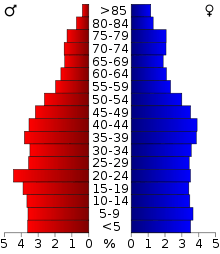
As of the census[19] of 2010, there were 95,535 people, 38,170 households, and 25,497 families residing in the city. The population density was 3,032.7 people per square mile (1,170.9/km²). There were 41,605 housing units at an average density of 1,254.7 per square mile (484.4/km²). The racial makeup of the city was 53.3% African American, 41.6% White, 0.4% Native American, 1.1% Asian, 0.1% Pacific Islander, 1.0% from other races, and 2.6% from two or more races. Hispanic or Latino of any race were 3.1% of the population.
There were 38,170 households out of which 30.6% had children under the age of 18 living with them, 41.1% were married couples living together, 10.9% have a female household with no husband present and 33.2% were non-families. 27.5% of all households were made up of individuals and 10.8% had someone living alone who was 65 years of age or older. The average household size was 2.51 and the average family size was 3.05.
In the city the population was spread out with 25.7% under the age of 18, 11.1% from 18 to 24, 29.1% from 25 to 44, 20.3% from 45 to 64, and 13.8% who were 65 years of age or older. The median age was 34 years. For every 100 females there were 93.5 males. For every 100 females age 18 and over, there were 90.6 males.
The median income for a household in the city was $46,340, and the median income for a family was $53,769. Males had a median income of $39,871 versus $33,140 for females. The per capita income for the city was $23,108. About 13.5% of families and 16.7% of the population were below the poverty line, including 27.1% of those under age 18 and 10.8% of those age 65 or over.[20]
Arts and culture
Tourism
Portsmouth has a long history as a port town and city. The Olde Towne Business and Historical District is located in the downtown area, where a combination of preservation and redevelopment has been underway. An example is Hawthorn Hotel & Suites at The Governor Dinwiddie Hotel, which was renovated and reopened in 2005 after being closed for more than 10 years. It has been recognized by Historic Hotels of America, a program of the National Trust for Historical Preservation that identifies hotels that have maintained their historical integrity, architecture and ambiance and provides resources for their preservation.[21] The historic hotel was named for Governor Robert Dinwiddie, who was the administrative head of the Colony of Virginia during the time Portsmouth was founded in 1752. It was largely through his efforts that Virginia survived the French and Indian War relatively well.[22] (Dinwiddie County near Petersburg was also named for him).
Other points of interest include the Portsmouth City Park, featuring the 2 ft (610 mm) narrow gauge[23] Portsmouth City Railroad with an operating Chance Rides C.P. Huntington locomotive named Pokey Smokey II. The original Pokey Smokey locomotive was built by Crown Metal Products and ran at the park for many years before being sold at auction. It now runs on the Mideast Railroad in Ederville in Carthage, North Carolina.[24][25]
Sports
The Portsmouth Cavaliers are a basketball team founded in 2010 and scheduled to begin play in the American Basketball Association for the 2011-12 season. Based in Portsmouth, Virginia, the Cavaliers play their home games at the Chick-fil-A Fieldhouse on the campus of Portsmouth Catholic Regional School. Portsmouth is also the home of the Portsmouth Mustangs Semi-Pro Football.
Government
Portsmouth is governed under the Council-Manager form of government. The current Mayor of Portsmouth, Virginia is Kenneth I. Wright,[26] who was elected November 2, 2010 for the remainder of the unexpired term to end December 31, 2012,[27] and re-elected on November 6, 2012.[28] The City Hall Building, located at 801 Crawford Street, is the regular meeting place of the City Council of The City of Portsmouth, Virginia. The City Council is a legislative body served by six members, elected for four-year terms.
Education
Secondary schools
There are three public high schools in Portsmouth, Virginia, located at three corners of the city. In the northwest section of the city, off Cedar Lane, is Churchland High School. In the downtown section of the city, between London Blvd and High Street, is I.C. Norcom High School. In the southwest section of Portsmouth, on Elmhurst Lane, is Woodrow Wilson High School.
Higher education
There are a number of institutions of higher education in and within close proximity to Portsmouth. The city is home to the Tri-Cities Higher Education Center of Old Dominion University (ODU), a public research university founded in 1930 whose main campus is located in Norfolk, Virginia.[29] Portsmouth is also home to the Fred W. Beazley Portsmouth Campus of Tidewater Community College, a two-year higher education institution founded in 1968 in South Hampton Roads with additional campuses located in Chesapeake, Norfolk, and Virginia Beach.[30]
Media
Portsmouth's daily newspaper is the Virginian-Pilot with The Currents being the Portsmouth edition of the Sunday paper. Other papers include the New Journal and Guide, and the Hampton Roads Business Journal.[31] Hampton Roads Magazine serves as a bi-monthly regional magazine for Portsmouth and the Hampton Roads area.[32] The Hampton Roads Times serves as an online magazine for all the Hampton Roads cities and counties. Portsmouth is served by a variety of radio stations on the AM and FM dials, with towers located around the Hampton Roads area.[33]
Portsmouth is also served by several television stations. The Hampton Roads designated market area (DMA) is the 42nd largest in the U.S. with 712,790 homes (0.64% of the total U.S.).[34] The major network television affiliates are WTKR-TV 3 (CBS), WAVY 10 (NBC), WVEC-TV 13 (ABC), WGNT 27 (CW), WTVZ 33 (MyNetworkTV), WVBT 43 (Fox), and WPXV 49 (ION Television). The Public Broadcasting Service stations are WHRO-TV 15, Hampton/Norfolk and WUND-TV 2, Edenton, NC. Portsmouth residents also can receive independent stations, such as WSKY broadcasting on channel 4 from the Outer Banks of North Carolina and WGBS-LD broadcasting on channel 11 from Hampton. Portsmouth is served by Cox Cable and Verizon FIOS. DirecTV and Dish Network are also popular as an alternative to cable television in Portsmouth. WAVY-TV and WVBT-TV are both sister stations owned by Media General and have their office and studio located in the city.
Infrastructure
Transportation
From the earliest development, Portsmouth has been oriented to the water. In the 1830s, it was the first community in Hampton Roads to receive a new land transportation innovation, railroad service. The Portsmouth and Roanoke Railroad, a predecessor of the Seaboard Air Line Railroad, extended to the rapids of the Roanoke River on its fall line near Weldon, North Carolina. It was to be 20 more years before its bigger neighbor, the city of Norfolk, also received a rail line, in 1858, when the Norfolk and Petersburg Railroad was completed.
Portsmouth is primarily served by the Norfolk International Airport (IATA: ORF, ICAO: KORF, FAA LID: ORF), now the region's major commercial airport. The airport is located near Chesapeake Bay, along the city limits of neighboring Norfolk and Virginia Beach.[35] Seven airlines provide nonstop services to twenty-five destinations. ORF had 3,703,664 passengers take off or land at its facility and 68,778,934 pounds of cargo were processed through its facilities.[36] Newport News/Williamsburg International Airport (IATA: PHF, ICAO: KPHF, FAA LID: PHF) also provides commercial air service for the Hampton Roads area.[37] The Chesapeake Regional Airport provides general aviation services and is located five miles (8 km) outside the city limits.[38]
In the 21st century, the city has access to lines of CSX Transportation, Norfolk Southern and three short line railroads. Portsmouth is served by Interstate 264 and Interstate 664, which is part of the Hampton Roads Beltway. U.S. Route 17 and U.S. Route 58 pass through. The Elizabeth River is crossed via the Midtown Tunnel, the Downtown Tunnel and Berkley Bridge combination.
Transportation within the city, as well as the other cities of Hampton Roads, is served by a regional bus service, Hampton Roads Transit.[39]
Notable people
- V. C. Andrews (1923-1986), bestselling novelist [40]
- Marty Brennaman (1942-), long-time Cincinnati Reds radio broadcaster
- Ruth Brown (1928–2006), R&B singer and actress[41]
- Bebe Buell (1953-), Playboy Playmate, fashion model, singer, mother of Liv Tyler
- John T. Casteen III (1943-), President of the University of Virginia, born in Portsmouth[42]
- Jamin Elliott (1979-), former NFL wide receiver with the Chicago Bears, New England Patriots, and Atlanta Falcons.[43]
- Missy Elliott (1971-), recording artist, award winning producer, singer-songwriter, dancer, actress and clothing line designer[44]
- Perry Ellis (1940–1986), fashion designer who founded a sportswear house in the mid-1970s[45]
- Mordechai Gifter (1915-2001), among the foremost American religious leaders of Orthodox Jewry in the late 20th century[46]
- Chandler Harper, (1914–2004), winner of the 1950 PGA golf championship[47]
- James W. Holley, III (1926-2012), politician, first African American Mayor of any Hampton Roads City[48]
- Ben Jones, actor "Cooter" on The Dukes of Hazzard; United States Congressman. Moved to Portsmouth as a child.[49]
- Jillian Kesner-Graver (1949-2007), actress[50]
- Jack T. Kirby (1938–2009), historian of the Southern United States, who was awarded the Bancroft Prize for his 2006 book Mockingbird Song: Ecological Landscapes of the South[51]
- Nathan McCall (1955-), is an African-American author who grew up in the Cavalier Manor section of Portsmouth, Virginia[52]
- Pete Mikolajewski (1943-), football player[53]
- James Murphy (1967-), metal guitarist, who has been a member of the bands Death, Testament, Obituary and Disincarnate
- Tommy Newsom (1929–2007), assistant bandleader for the Johnny Carson Band[54]
- Patton Oswalt (1969-), writer, stand-up comedian, and actor
- Dave Robertson (1889-1970), MLB outfielder 1912-22, played in World Series for New York Giants; born in Portsmouth
- Dave Smith (1942-), poet, novelist
- Wanda Sykes (1964-), writer, stand-up comedian, and actress
- Ted Thomas, Sr. (1935-), Pentecostal African-American preacher, pastor of New Community Temple Church of God in Christ
- Mike Watt (1957-), bassist, singer and songwriter
- Nicole Wray , R&B singer and songwriter
Sister cities
 Portsmouth, United Kingdom
 Dunedin, New Zealand
 Orizaba, Mexico
 Eldoret, Kenya
 Goree Island, Senegal
See also
Notes
- ↑ Mean monthly maxima and minima (i.e. the expected highest and lowest temperature readings at any point during the year or given month) calculated based on data at said location from 1981 to 2010.
- ↑ Official records for Norfolk kept January 1874 to December 1945 at the Weather Bureau Office in downtown, and at Norfolk Int'l since January 1946. For more information, see Threadex
References
- ↑ "American FactFinder". United States Census Bureau. Retrieved 2008-01-31.
- ↑ "US Board on Geographic Names". United States Geological Survey. 2007-10-25. Retrieved 2008-01-31.
- 1 2 "State & County QuickFacts". United States Census Bureau. Retrieved January 6, 2014.
- 1 2 City of Portsmouth, Virginia - History
- ↑ Baker, Barnabas W.; Burgess, Dean. "William Craford (d. by April 15, 1762)". Encyclopedia Virginia. Retrieved 22 June 2015.
- ↑ Portsmouth, Virginia, Department of Economic Development
- ↑ "www.med.navy.mil". Naval Medical Center Portsmouth. US Navy. Retrieved June 11, 2016.
- ↑ "US Gazetteer files: 2010, 2000, and 1990". United States Census Bureau. 2011-02-12. Retrieved 2011-04-23.
- 1 2 "NowData - NOAA Online Weather Data". National Oceanic and Atmospheric Administration. Retrieved 2016-09-07.
- ↑ Information from NOAA.
- ↑ "Quick Data View Norfolk." National Oceanic and Atmospheric Administration. 1971–2000.
- ↑ "Station Name: VA NORFOLK INTL AP". National Oceanic and Atmospheric Administration. Retrieved 2016-09-07.
- ↑ "WMO Climate Normals for NORFOLK/INTL, VA 1961–1990". National Oceanic and Atmospheric Administration. Retrieved 2014-03-10.
- ↑ "Annual Estimates of the Resident Population for Incorporated Places: April 1, 2010 to July 1, 2015". Retrieved July 2, 2016.
- ↑ "U.S. Decennial Census". United States Census Bureau. Retrieved January 6, 2014.
- ↑ "Historical Census Browser". University of Virginia Library. Retrieved January 6, 2014.
- ↑ "Population of Counties by Decennial Census: 1900 to 1990". United States Census Bureau. Retrieved January 6, 2014.
- ↑ "Census 2000 PHC-T-4. Ranking Tables for Counties: 1990 and 2000" (PDF). United States Census Bureau. Retrieved January 6, 2014.
- ↑ "American FactFinder". United States Census Bureau. Retrieved 2011-05-14.
- ↑ http://factfinder2.census.gov/bkmk/table/1.0/en/ACS/11_5YR/DP03/0500000US51740
- ↑ Topic Galleries - dailypress.com Archived October 11, 2007, at the Wayback Machine.
- ↑ Robert Dinwiddie - Ohio History Central - A product of the Ohio Historical Society
- ↑ Pokey Smokey locomotive
- ↑ PilotOnline.com - Portsmouth's Pokey Smokey is sold to N.C. railroad contractor
- ↑ Ederville - official website
- ↑ "The Honorable Kenneth I. Wright - City of Portsmouth, Virginia - City Council". Retrieved July 28, 2012.
- ↑ "City of Portsmouth, Virginia - Unofficial Election Results". Retrieved July 28, 2012.
- ↑ "City of Portsmouth, Virginia - Voter Registration & Elections". Retrieved December 13, 2012.
- ↑ "About ODU - Old Dominion University". ODU. Retrieved 2012-11-13.
- ↑ "About Tidewater Community College". TCC. Retrieved 2012-11-13.
- ↑ "Hampton Roads News Links". abyznewslinks.com. Retrieved 2007-08-06.
- ↑ "Hampton Roads Magazine". Hampton Roads Magazine. Retrieved 2007-08-06.
- ↑ "Hampton Roads Radio Links". ontheradio.net. Retrieved 2007-08-06.
- ↑ Holmes, Gary. "Nielsen Reports 1.1% increase in U.S. Television Households for the 2006-2007 Season." Nielsen Media Research. September 23, 2006. Retrieved on September 28, 2007.
- ↑ "Norfolk International Airport Mission and History". Norfolk International Airport. Archived from the original on September 28, 2007. Retrieved 2007-10-02.
- ↑ "Norfolk International Airport Statistics" (PDF). Norfolk International Airport. Archived from the original (PDF) on October 25, 2007. Retrieved 2007-10-02.
- ↑ "Newport News/Williamsburg International Airport". Newport News/Williamsburg International Airport. Retrieved 2008-02-25.
- ↑ "Chesapeake Regional Airport". Retrieved 2008-01-12.
- ↑ Hampton Roads Transit
- ↑ Campbell, Edward D. C., Jr. (July 8, 2013). "V. C. Andrews (1923–1986)". Dictionary of Virginia Biography. Encyclopedia Virginia. Retrieved February 2016. Check date values in:
|access-date=(help) - ↑ Gulla, Bob (2008). Icons of R&B and Soul, p. 72. Greenwood Publishing Group.
- ↑ "49th TCC Commencement". Tidewater Community College. October 27, 2009. Retrieved February 2016. Check date values in:
|access-date=(help) - ↑ "Jamin Elliott, WR at NFL.com". National Football League. Retrieved February 2016. Check date values in:
|access-date=(help) - ↑ "Missy Elliott Biography". The Biography.com website. A&E Television Networks. Retrieved February 2016. Check date values in:
|access-date=(help) - ↑ "Perry Ellis Biography". The Biography.com website. A&E Television Networks. Retrieved February 2016. Check date values in:
|access-date=(help) - ↑ Gerber, Alan Jay (January 19, 2012). "The Kosher Bookworm From Portsmouth Virginia to Telz The Legacy of Rabbi Mordechai Gifter". The Jewish Star. Retrieved February 2016. Check date values in:
|access-date=(help) - ↑ Litsky, Frank (November 12, 2004). "Chandler Harper, Winner of 7 Professional Golf Tournaments, Dies at 90". New York Times. Retrieved February 2016. Check date values in:
|access-date=(help) - ↑ Forster, Dave; Harki, Gary (October 6, 2012). "Former Portsmouth Mayor James Holley dies at 85". The Virginian-Pilot. Retrieved February 2016. Check date values in:
|access-date=(help) - ↑ "Ben Jones: A Conversation". Georgia Public Broadcasting. Retrieved April 2014. Check date values in:
|access-date=(help) - ↑ "Finishing Welles' film became her mission". Los Angeles Times. December 21, 2007. Retrieved February 2016. Check date values in:
|access-date=(help) - ↑ Hevesi, Dennis. "Jack T. Kirby, Southern Historian, Dies at 70", The New York Times, August 13, 2009. Accessed August 14, 2009.
- ↑ Washington, Nicholas L. (April 15, 2014). "Nathan McCall: 20 Years After 'Makes Me Wanna Holler'". Ebony. Retrieved February 2016. Check date values in:
|access-date=(help) - ↑ "PETE MIKOLAJEWSKI". profootballarchives.com. Retrieved October 30, 2015.
- ↑ Bernstein, Adam (May 1, 2007). "Jazz Saxophonist Tommy Newsom; Played on 'Tonight Show'". "The Washington Post". Retrieved March 2016. Check date values in:
|access-date=(help)
External links
| Wikimedia Commons has media related to Portsmouth, Virginia. |
| Wikisource has the text of a 1911 Encyclopædia Britannica article about Portsmouth, Virginia. |
 |
Chesapeake Bay | | ||
| City of Suffolk | |
City of Norfolk | ||
| ||||
| | ||||
| City of Chesapeake | City of Chesapeake | City of Chesapeake |