Martinsville, Virginia
| Martinsville, Virginia | ||
|---|---|---|
| Independent city | ||
|
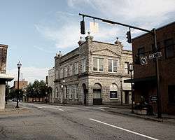
Martinsville's uptown district | ||
| ||
 | ||
| Coordinates: 36°41′10″N 79°52′9″W / 36.68611°N 79.86917°W | ||
| Country | United States | |
| State | Virginia | |
| County | None (Independent city) | |
| Government | ||
| • Mayor | Danny Turner | |
| Area | ||
| • Total | 11.0 sq mi (28 km2) | |
| • Land | 11.0 sq mi (28 km2) | |
| • Water | 0.1 sq mi (0.3 km2) | |
| Elevation | 1,017 ft (310 m) | |
| Population (2010) | ||
| • Total | 13,821 | |
| • Density | 1,256/sq mi (485/km2) | |
| Time zone | Eastern (EST) (UTC-5) | |
| • Summer (DST) | EDT (UTC-4) | |
| ZIP codes | 24112-24115 | |
| Area code(s) | 276 | |
| FIPS code | 51-49784[1] | |
| GNIS feature ID | 1498514[2] | |
| Website | http://www.martinsville-va.gov | |
Martinsville is an independent city near the southern border of the U.S. state of Virginia. As of the 2010 census, the population was 13,821.[3] It is the county seat of Henry County,[4] although the two are separate jurisdictions. The Bureau of Economic Analysis combines the city of Martinsville with Henry County for statistical purposes.
Martinsville is the principal city of the Martinsville Micropolitan Statistical Area, with a population of 73,346 as of the 2000 census.
The paper clip-shaped Martinsville Speedway, the shortest track in the NASCAR Sprint Cup Series at 0.526 miles (847 m) and one of the first paved "speedways," is located just outside the city near the town of Ridgeway.
History
Martinsville was founded by American Revolutionary War General, Indian agent and explorer Joseph Martin, born in Albemarle County.[5] He developed his plantation Scuffle Hill on the banks of the Smith River near the present-day southern city limits. General Martin and revolutionary patriot Patrick Henry, who lived briefly in Henry County and for whom the county is named, were good friends.
The city's chief industry for many early years was the manufacture of plug chewing tobacco. The Henry County area became known as the "plug tobacco capital of the world." In the wake of the collapse of the plantation economy following the American Civil War, the local economy was reeling. Stepping into the breach were several thriving plug firms which sold their merchandise across the nation beginning in the nineteenth century.
Local families were heavily involved in these companies, bestowing their names on them and reaping sizeable profits until the early twentieth century, when the tobacco monopolies created by R.J. Reynolds and James Buchanan Duke bought out most firms. (In most cases, in bold anti-competitive moves, the two tobacco titans simply shut down their acquisitions overnight.[6] These actions resulted in a U.S. government lawsuit against American Tobacco Company.[7]) Among the earliest of these firms were D.H. Spencer & Sons and Spencer Bros. Other families soon joined in founding other early firms, including the Gravelys, the Comptons, the Ruckers, the Wittens, the Lesters and the Browns.
The city's main industry for a century was furniture construction, and today Virginia furniture makers still reside in the region. Martinsville declared itself an independent city in 1928, while retaining its status as county seat. (In the 21st century however, it is a county seat in name only, as all of Henry County's administrative and judicial functions are carried out from the administration building and courthouse in nearby Collinsville.)
DuPont in 1941 built a large manufacturing plant for producing textile nylon filament, a vital war material. During the Cold War, the city was identified as a target for strategic bombing by the Soviet Union. This nylon production jump-started the growth of the textiles industry in the area. For several years Martinsville was known as the "Sweatshirt Capital of the World."
Business leaders in the mid-20th century, like Whitney Shumate, worked to improve sub-standard housing in Martinsville. He helped clear out a portion of Martinsville called "Mill Town", which had sub-standard rental housing originally provided in the 19th century for the defunct cotton mill employees. New homes were constructed in the neighborhood, built with sound materials and with all city services for the first time. What had originally been considered a depressed civic area rapidly became a center of progress as middle class blacks finally began to prosper. As an editorial in the local newspaper noted, "One of the projects which won him considerable attention and praise was the instigation of the redevelopment of what was once known as Martinsville Cotton Mill Village. He and associates purchased about 50 houses in North Martinsville, and using private capital rather than federal aid, rebuilt them into comfortably inhabitable homes, making it possible for many persons to purchase homes within their financial range."[8]
In the early 1990s, changing global economic conditions and new trade treaties made Martinsville textiles and furniture manufacturing economically unsustainable. Many firms closed shop and laid off thousands of workers; the production moved offshore to other countries.[9] The city is repositioning itself long-term as a center for technology development and manufacturing. Due to the local government's inability to fund certain services, in the near future the city of Martinsville may decide to legally convert into the town of Martinsville.
MZM, Inc. opened a facility in Martinsville as part of the Cunningham scandal.
The Martinsville City School District has Martinsville High School, which averages about 900 students. As of 2009, the high school had the second-highest teen pregnancy rate in the state, along with the highest S.T.D. rate.[10] The high school chose to make contraceptives available in school, in order to reduce the rates of both pregnancy and STDs. The Martinsville City Public Schools system has 1 high school, 1 middle school, 2 elementary schools, and 1 preschool.
Additionally, there is a private P.S.-12 school near Martinsville in Henry County, Carlisle School. The school serves approximately 600 students, about 130 of them high school students.
Martinsville is also home to the Virginia Museum of Natural History, an affiliate of the Smithsonian Institution. It was founded by Martinsville native Dr. Noel Boaz, and Piedmont Arts Association, a nonprofit art museum and affiliate of the Virginia Museum of Fine Arts.
Memorial Hospital of Martinsville serves the greater Martinsville and Henry County area. The earliest local hospital was the 50-bed Shackelford Hospital,[11] founded by Dr. Jesse Martin Shackelford,[12] who was later joined by surgeon son Dr. John Armstrong Shackelford, an early graduate of Johns Hopkins University School of Medicine.[13] Founder of the Hospital Association of Virginia, Dr. Jesse Shackelford was an early advocate of comprehensive care for state citizens. Shackelford Hospital was sold in 1946, and Martinsville General Hospital subsequently opened with Dr. John Shackelford as its first chief surgeon.[14] In 1970 Memorial Hospital of Martinsville opened its doors, replacing Martinsville General.
The Beaver Creek Plantation, John Waddey Carter House, Dry Bridge School, East Church Street-Starling Avenue Historic District, Fayette Street Historic District, Little Post Office, Martinsville Fish Dam, Martinsville Historic District, Martinsville Novelty Corporation Factory, and Scuffle Hill are listed on the National Register of Historic Places.[15]
Liberty Fair Mall opened in 1989.
Geography
According to the United States Census Bureau, the city has a total area of 11.0 square miles (28.5 km2), of which 11.0 square miles (28.5 km2) is land and 0.1 square miles (0.3 km2) (0.5%) is water.[16] The north side of the city has the highest average elevation. The east side slopes gradually down to the Smith River on the south side. The west side is hilly.
Demographics
| Historical population | |||
|---|---|---|---|
| Census | Pop. | %± | |
| 1880 | 289 | — | |
| 1900 | 2,384 | — | |
| 1910 | 3,368 | 41.3% | |
| 1920 | 4,075 | 21.0% | |
| 1930 | 7,705 | 89.1% | |
| 1940 | 10,080 | 30.8% | |
| 1950 | 17,251 | 71.1% | |
| 1960 | 18,798 | 9.0% | |
| 1970 | 19,653 | 4.5% | |
| 1980 | 18,149 | −7.7% | |
| 1990 | 16,162 | −10.9% | |
| 2000 | 15,416 | −4.6% | |
| 2010 | 13,821 | −10.3% | |
| Est. 2015 | 13,645 | [17] | −1.3% |
| U.S. Decennial Census[18] 1790-1960[19] 1900-1990[20] 1990-2000[21] 2010-2012[3] | |||
As of the census[22] of 2000, there were 15,416 people, 6,498 households, and 4,022 families residing in the city. The population density was 1,407.1 people per square mile (543.1/km²). There were 7,249 housing units at an average density of 661.7 per square mile (255.4/km²). The racial makeup of the city was 55.38% White, 42.55% African American, 0.10% Native American, 0.47% Asian, 0.69% from other races, and 0.81% from two or more races. Hispanics or Latinos of any race were 2.32% of the population.
There were 6,498 households out of which 26.3% had children under the age of 18 living with them, 39.0% were married couples living together, 19.1% had a female householder with no husband present, and 38.1% were non-families. 34.2% of all households were made up of individuals and 15.4% had someone living alone who was 65 years of age or older. The average household size was 2.27 and the average family size was 2.89.
The age distribution was 22.6% under the age of 18, 7.0% from 18 to 24, 26.7% from 25 to 44, 23.2% from 45 to 64, and 20.6% who were 65 years of age or older. The median age was 41 years. For every 100 females there were 82.4 males. For every 100 females age 18 and over, there were 78.4 males.
The median income for a household in the city was $27,441, and the median income for a family was $35,321. Males had a median income of $28,530 versus $21,367 for females. The per capita income for the city was $17,251. About 14.0% of families and 19.2% of the population were below the poverty line, including 25.6% of those under age 18 and 16.9% of those age 65 or over. As of August 2010, the city's unemployment rate stood at 20 percent.[23]
Culture
Sports
Martinsville is home to the Martinsville Mustangs of the Coastal Plain League, a collegiate summer baseball league. The Mustangs play at Hooker Field in Martinsville. The Mustangs began play for the league's 2005 season.
Martinsville is also home to Martinsville Speedway, which opened in 1947. The NASCAR Sprint Cup Series hosts two races there every year.
Notable people
- Rabih Abdullah – National Football League player
- Baton Bob – Costumed street performer
- John Robert Brown (Virginia politician) – US House of Representatives
- Thomas G. Burch – American farmer, tobacco manufacturer, and politician (US House of Representatives and US Senate)
- Greg Gaines – National Football League player
- Carl Hairston – National Football League player
- George Hairston plantation owner, former sheriff of Henry County, Brigadier General, War of 1812
- Robert Hairston plantation owner, former sheriff of Henry County, captain of militia, French and Indian War
- Patrick Henry – American patriot (resided at Leatherwood Plantation, Henry County, outside current city limits)
- Magdalen Hsu-Li – American singer-songwriter, painter, speaker, poet, and activist
- Kristen-Paige Madonia – Novelist and creative writing teacher
- General Joseph Martin – American Revolutionary War general, explorer, legislator, Indian agent
- Barry Michaels – American radio personality
- Shawn Moore – National Football League and Canadian Football League player
- Stephen Mark Rainey – Author of novels, short stories, and various works of nonfiction
- Jessamine Shumate – artist, painter
- Whitney Shumate - businesman, developer
- Sonny Wade – Canadian Football League player
- Stafford G. Whittle – Judge, Virginia Supreme Court of Appeals
- Kennon C. Whittle – Judge, Virginia Supreme Court of Appeals
- Red Top Young – Blues, rhythm and blues, country, rock & roll, and jazz musician
- Delvin Joyce – National Football League player
- Clinton Gregory Country Singer and Fiddle Player
Gallery
 Home of Henry Clay Lester, early tobacco manufacturer, Main Street, Martinsville. Home burned in the early 1940s
 Henry County Courthouse Square, Martinsville, circa 1890.
 Staff of Draper's Barber Shop, Franklin Street, Martinsville, 1920. White bowls on floor are spittoons
 Pannill Knitting Company, early Martinsville textile concern founded in 1926
 Oak Hall, home of Col. Pannill Rucker, early Martinsville tobacco manufacturer. Oak Hall burned February 19, 1917
 Class of 1912, Martinsville High School
 Shackelford Hospital, founded by Dr. Jesse Martin Shackelford, predecessor of Martinsville Memorial Hospital
See also
References
- ↑ "American FactFinder". United States Census Bureau. Retrieved 2008-01-31.
- ↑ "US Board on Geographic Names". United States Geological Survey. 2007-10-25. Retrieved 2008-01-31.
- 1 2 "State & County QuickFacts". United States Census Bureau. Retrieved January 6, 2014.
- ↑ "Find a County". National Association of Counties. Archived from the original on May 31, 2011. Retrieved 2011-06-07.
- ↑ '' Virginia: A Guide to the Old Dominion''(Sixth Printing, 1956). Virginia Writers' Project, Work Projects Administration. p. 611. New York: Oxford University Press. Books.google.com. Retrieved on May 9, 2012.
- ↑ The Tobacco Worker, Tobacco Workers International Union, 1907. Books.google.com. Retrieved on May 9, 2012.
- ↑ Federal Anti-trust Decisions, Government Printing Office, Washington, D.C., 1917. Books.google.com. Retrieved on May 9, 2012.
- ↑ Martinsville Bulletin. March 3, 1966. "City Loses Citizen who Helped Make it a Better Community."
- ↑ "Threadbare: The Unravelling of Henry County", The Roanoke Times, 17 August 2002. (August 17, 2002). Retrieved on May 9, 2012.
- ↑ Thompson, Karen (August 30, 2009). "MHS Health Center tackles issues of pregnancy, STDs". Martinsville Bulletin. Retrieved January 5, 2012.
- ↑ The Doctors Shackelford and the Shackelford Hospital, Martinsville-Henry County Historical Society. Mhchistoricalsociety.com (October 8, 2009). Retrieved on May 9, 2012.
- ↑ Jesse Martin Shackelford, M.D., Martinsville Henry County Historical Society. Mhchistoricalsociety.com (October 6, 2009). Retrieved on May 9, 2012.
- ↑ John Armstrong Shackelford, M.D., Martinsville-Henry County Historical Society. Mhchistoricalsociety.com (October 6, 2009). Retrieved on May 9, 2012.
- ↑ The History of Memorial Hospital. Martinsvillehospital.org. Retrieved on May 9, 2012.
- ↑ National Park Service (2010-07-09). "National Register Information System". National Register of Historic Places. National Park Service.
- ↑ "US Gazetteer files: 2010, 2000, and 1990". United States Census Bureau. 2011-02-12. Retrieved 2011-04-23.
- ↑ "Annual Estimates of the Resident Population for Incorporated Places: April 1, 2010 to July 1, 2015". Retrieved July 2, 2016.
- ↑ "U.S. Decennial Census". United States Census Bureau. Archived from the original on May 11, 2015. Retrieved January 6, 2014.
- ↑ "Historical Census Browser". University of Virginia Library. Retrieved January 6, 2014.
- ↑ "Population of Counties by Decennial Census: 1900 to 1990". United States Census Bureau. Retrieved January 6, 2014.
- ↑ "Census 2000 PHC-T-4. Ranking Tables for Counties: 1990 and 2000" (PDF). United States Census Bureau. Retrieved January 6, 2014.
- ↑ "American FactFinder". United States Census Bureau. Retrieved 2011-05-14.
- ↑ "To Help or Not to Help". The Economist. August 26, 2010. Retrieved August 30, 2010.
External links
- City of Martinsville
- Martinsville Bulletin
- Martinsville Speedway
- Martinsville Tourism information
- New College Institute
- Piedmont Arts Association
- Virginia Museum of Natural History
- Old Photos
- Martinsville City – The Carolina Road, Wilderness Road, virginia.org
- Ghost Town, George Packer, The New Yorker, March 15, 2010
- Movies of Local People: Martinsville, VA, 1938, from the H. Lee Waters Film Collection
Coordinates: 36°41′10″N 79°52′09″W / 36.686143°N 79.869171°W