Danielson, Connecticut
| Danielson, Connecticut | |
|---|---|
| Borough | |
 Location in Windham County and the state of Connecticut. | |
| Coordinates: 41°48′29″N 71°53′03″W / 41.80806°N 71.88417°WCoordinates: 41°48′29″N 71°53′03″W / 41.80806°N 71.88417°W | |
| Country | United States |
| State | Connecticut |
| Area | |
| • Total | 1.2 sq mi (3.2 km2) |
| • Land | 1.1 sq mi (2.9 km2) |
| • Water | 0.1 sq mi (0.3 km2) |
| Elevation | 223 ft (68 m) |
| Population (2000) | |
| • Total | 4,265 |
| • Density | 3,860.7/sq mi (1,490.6/km2) |
| Time zone | Eastern (EST) (UTC-5) |
| • Summer (DST) | EDT (UTC-4) |
| ZIP code | 06239 |
| Area code(s) | 860 |
| FIPS code | 09-18780 |
| GNIS feature ID | 0206590 |
Danielson is a borough in the town of Killingly in Windham County, Connecticut, United States. The population was 4,051 at the 2010 census.
History
Danielson was named for Gen. James Danielson, the builder of the first house in the settlement.[1]
Historic districts

Danielson is the site of two historic districts listed on the National Register of Historic Places:
- Danielson Main Street Historic District is a 20-acre (81,000 m2) historic district along Main Street, from Water Street to Spring Street. Architectural styles in the district include Colonial Revival and Italianate, as well as others. The Danielson Main Street Historic District was added to the National Register of Historic Places on April 8, 1992.[2]
- Broad Street – Davis Park Historic District – roughly along Broad Street, from Dorrance Street to Winter Street, to the north of Danielson Main Street Historic District. Architectural styles represented include Stick/Eastlake, Queen Anne, and Colonial Revival. It was added to the National Register of Historic Places in 1998.[2]
It additionally is home to the Temple Beth Israel synagogue, which was added to the National Register of Historic Places in 2003.[2]Danielson is also home to the legendary CT State Police barracks "D".
Geography
According to the United States Census Bureau, the borough has a total area of 1.2 square miles (3.1 km2), of which 1.1 square miles (2.8 km2) is land and 0.1 square miles (0.26 km2) (9.02%) is water.
Demographics
| Historical population | |||
|---|---|---|---|
| Census | Pop. | %± | |
| 1900 | 2,823 | — | |
| 1910 | 2,934 | 3.9% | |
| 1920 | 3,130 | 6.7% | |
| 1930 | 4,210 | 34.5% | |
| 1940 | 4,507 | 7.1% | |
| 1950 | 4,554 | 1.0% | |
| 1960 | 4,642 | 1.9% | |
| 1970 | 4,580 | −1.3% | |
| 1980 | 4,553 | −0.6% | |
| 1990 | 4,441 | −2.5% | |
| 2000 | 4,265 | −4.0% | |
| 2010 | 4,051 | −5.0% | |
| Est. 2015 | 3,987 | [3] | −1.6% |

As of the census[5] of 2010, there were 4,051 people, 1,627 households, and 975 families residing in the borough. The population density was 3,682.7 people per square mile (1,446.8/km²). There were 1,627 housing units at an average density of 1,479.0/sq mi (681.1/km²). The racial makeup of the borough was 88.7% White, 2.8% African American, 0..5% Native American, 2.9% Asian, 1.5% from other races, and 3.5% from two or more races. Hispanic or Latino of any race were 5.7% of the population.
The borough of Danielson and the town of Killingly are home to a small Laotian community. Both Danielson and Killingly are on the nation's list of top 50 cities with the highest percentage of citizens claiming Laotian ancestry.
Of the 1,627 households: 29.9% had children under the age of 18 living with them, 34.4% were married couples living together, 17.9% had a female householder with no husband present, and 40.1% were non-families. 30.2% of all households were made up of individuals and 9.6% had someone living alone who was 65 years of age or older. The average household size was 2.45 and the average family size was 2.99.
In the borough the population was spread out with 24.0% under the age of 18, 10.9% from 18 to 24, 30.6% from 25 to 44, 24.5% from 45 to 64, and 10.0% who were 65 years of age or older. The median age was 35 years. For every 100 females there were 96.9 males. For every 100 females age 18 and over, there were 95.9 males.
The median income for a household in the borough was $58,933, and the median income for a family was $62,803. Males had a median income of $44,235 versus $34,236 for females. The per capita income for the borough was $23,935. About 9.6% of families and 14.1% of the population were below the poverty line, including 21.1% of those under age 18 and 6.8% of those age 65 or over.
Transportation
Danielson Airport is a state owned, public use airport located two nautical miles (4 km) northwest of the central business district of Danielson.[6] I-395 runs north and south through the town, and is the primary road for the borough. US 6 is the east-west road through the town, and severs the southern part of downtown. Route 12 runs through and severs downtown.
References
![]() Media related to Danielson, Connecticut at Wikimedia Commons
Media related to Danielson, Connecticut at Wikimedia Commons
- ↑ Gannett, Henry (1905). The Origin of Certain Place Names in the United States. Govt. Print. Off. p. 99.
- 1 2 3 National Park Service (2008-04-15). "National Register Information System". National Register of Historic Places. National Park Service.
- ↑ "Annual Estimates of the Resident Population for Incorporated Places: April 1, 2010 to July 1, 2015". Retrieved July 2, 2016.
- ↑ "Census of Population and Housing". Census.gov. Retrieved June 4, 2015.
- ↑ "American FactFinder". United States Census Bureau. Retrieved 2008-01-31.
- ↑ FAA Airport Master Record for LZD (Form 5010 PDF). Federal Aviation Administration. Effective May 31, 2012.

Municipalities and communities of Windham County, Connecticut, United States | ||
|---|---|---|
| Towns | 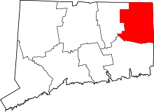 | |
| Borough | ||
| Other communities | ||