Bolton, Connecticut
| Bolton, Connecticut | ||
|---|---|---|
| Town | ||
| ||
| Motto: " A Town For All Seasons " | ||
 Location within Tolland County, Connecticut | ||
| Coordinates: 41°45′51″N 72°26′15″W / 41.76417°N 72.43750°WCoordinates: 41°45′51″N 72°26′15″W / 41.76417°N 72.43750°W | ||
| Country | United States | |
| State | Connecticut | |
| NECTA | Hartford | |
| Region | Capitol Region | |
| Incorporated | 1720 | |
| Government | ||
| • Type | Selectman-town meeting | |
| • First selectman | Robert R. Morra (R) | |
| • Selectmen |
Robert W. Neil (R) Gwen E. Marrion (D) Robert D. Lessard (D) Sandra Pierog (D) | |
| Area | ||
| • Total | 14.7 sq mi (38.1 km2) | |
| • Land | 14.4 sq mi (37.3 km2) | |
| • Water | 0.3 sq mi (0.7 km2) | |
| Elevation | 728 ft (222 m) | |
| Population (2010)[1] | ||
| • Total | 4,986 | |
| • Density | 340/sq mi (130/km2) | |
| Time zone | Eastern (UTC-5) | |
| • Summer (DST) | Eastern (UTC-4) | |
| ZIP code | 06043 | |
| Area code(s) | 860 | |
| FIPS code | 09-06260 | |
| GNIS feature ID | 0213393 | |
| Website |
bolton | |
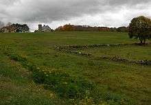
Bolton is a small rural town in Tolland County, Connecticut, United States. It is primarily residential, with an economy made up primarily of small businesses. The high school typically has between fifty and one hundred students per class. The population is 4,986 as of the 2010 census. Bolton was incorporated in October 1720 and is governed by town meeting.
History
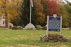
Originally part of the town of Hartford, the area was referred to as Hartford Mountains or Hanover, until incorporation in October 1720. The northern half of Bolton was set aside in 1808 to form the town of Vernon. Quarries played a significant role in the area’s developing economy and Bolton Notch became the location of the small community of Quarryville. Prior to the railroad, granite was taken by oxcart to the Connecticut River where it was the shipped to major cities on the East Coast.
On November 11, 1723, Jonathan Edwards was installed as the pastor of Bolton.[2]
It is widely speculated that in 1781, George Washington stayed at a home in Bolton. Later that year, the French army is confirmed to have passed through the town. On Rose's Farm, Rochambeau most likely stayed the night with his troops. Archaeological evidence proves that they were in Rose's field; and possibly also across the street (because of the current modern houses there this was
not proven). Archaeologists believe that the officers of the troops stayed there, since they usually stayed away from the troops because they considered themselves higher in status. The artifacts that would have been found if the grounds had been correctly excavated would have been very useful for the history of Bolton and therefore the statements above cannot be confirmed with full accuracy.
Climate
Bolton, like much of Tolland County straddles the humid continental climate (Dfa) and (Dfb) line. [3]
| Climate data for Bolton, Connecticut | |||||||||||||
|---|---|---|---|---|---|---|---|---|---|---|---|---|---|
| Month | Jan | Feb | Mar | Apr | May | Jun | Jul | Aug | Sep | Oct | Nov | Dec | Year |
| Record high °F (°C) | 64 (18) |
69 (21) |
83 (28) |
93 (34) |
92 (33) |
96 (36) |
97 (36) |
96 (36) |
96 (36) |
86 (30) |
78 (26) |
71 (22) |
97 (36) |
| Average high °F (°C) | 35 (2) |
38 (3) |
47 (8) |
58 (14) |
69 (21) |
76 (24) |
81 (27) |
80 (27) |
72 (22) |
62 (17) |
51 (11) |
40 (4) |
59.1 (15) |
| Average low °F (°C) | 13 (−11) |
15 (−9) |
24 (−4) |
33 (1) |
43 (6) |
52 (11) |
57 (14) |
56 (13) |
46 (8) |
35 (2) |
29 (−2) |
20 (−7) |
35.3 (1.8) |
| Record low °F (°C) | −32 (−36) |
−27 (−33) |
−24 (−31) |
4 (−16) |
20 (−7) |
27 (−3) |
34 (1) |
28 (−2) |
19 (−7) |
13 (−11) |
−5 (−21) |
−19 (−28) |
−32 (−36) |
| Average precipitation inches (mm) | 4.38 (111.3) |
3.11 (79) |
4.32 (109.7) |
4.54 (115.3) |
3.96 (100.6) |
4.25 (108) |
4.08 (103.6) |
4.07 (103.4) |
4.54 (115.3) |
4.56 (115.8) |
4.64 (117.9) |
4.02 (102.1) |
50.47 (1,281.9) |
| Source: The Weather Channel (Historical Monthly Averages)[4] | |||||||||||||
Education
Bolton High School is a public school with about three-to-four-hundred students. It underwent major renovations and expansion during 2011. Which included a new outdoor seating area for the cafeteria, a larger and more technologically advanced library, computer labs and media center as well as a new science wing and larger administrative offices. Several other improvements were made including parking, bus lanes and the Board of Education offices being moved to the location. The school has a student-teacher ratio of about 12:1 and combined math and reading proficiency level of 92.5%.[5] U.S. News & World Report ranked it as #27 in Connecticut and #1030 in the United States earning a Silver Award in 2012[6] Bolton High is affiliated with the NCCC athletic conference.
Sports
In Bolton High School's first year of participation, it won the boys conference tennis championship and placed as the runner up in the boys Class S state championship in cross country. The boys cross country team also won the conference championship in 2007, going undefeated with a record of 27-0. They went on to win the Connecticut Class S State Cross Country Championship in 2008, 2009, 2011, and 2012 under the direction of Coach Paul T. Smith . The boys tennis team has won the NCCC conference three years in a row finishing the 2009 season with a record of 17-0. Also of note, the hockey team (a co-op with Rockville and Coventry) were state runners up in 2013 when they advanced to the Division III state title game after winning their conference. The following year the boys soccer team also advanced to the Class S state championship game. The girls basketball and soccer teams frequently challenge for the conference title and often rank highly in the state tournaments.
The school's mascot is the bulldog, and the school's colors are blue and white.
Notable residents
- Ralph Earl, artist and portrait painter, died in Bolton in 1801.
- Ron Hainsey, NHL defenseman for the Carolina Hurricanes.
- Simeon Olcott, US Senator from New Hampshire was born in Bolton in 1735.
- George G. Sumner, (politician) Connecticut House of Representative for Bolton, Mayor of Hartford and Lieutenant Governor & Governor of Connecticut was a native.
- William Williams, was born in Bolton on September 6, 1815.
Maud L. Woodward, Connecticut House of Representatives from Bolton 1935-40.
Geography
According to the United States Census Bureau, the town has a total area of 14.7 square miles (38 km2), of which, 14.4 square miles (37 km2) of it is land and 0.3 square miles (0.78 km2) of it (1.91%) is water. It includes the Bolton Green Historic District.
Demographics
| Historical population | |||
|---|---|---|---|
| Census | Pop. | %± | |
| 1820 | 731 | — | |
| 1850 | 600 | — | |
| 1860 | 683 | 13.8% | |
| 1870 | 576 | −15.7% | |
| 1880 | 512 | −11.1% | |
| 1890 | 452 | −11.7% | |
| 1900 | 457 | 1.1% | |
| 1910 | 433 | −5.3% | |
| 1920 | 448 | 3.5% | |
| 1930 | 504 | 12.5% | |
| 1940 | 728 | 44.4% | |
| 1950 | 1,279 | 75.7% | |
| 1960 | 2,933 | 129.3% | |
| 1970 | 3,691 | 25.8% | |
| 1980 | 3,951 | 7.0% | |
| 1990 | 4,575 | 15.8% | |
| 2000 | 5,017 | 9.7% | |
| 2010 | 4,980 | −0.7% | |
| Est. 2014 | 4,952 | [7] | −0.6% |
As of the census[9] of 2010, there are 4,986 people, 1,918 households, and 1,441 families residing in the town. The town consists primarily of middle-class families with some working-class families/individuals and small businesses. There are also a few larger commercial entities; notably the Simoniz corporation, specializing in automotive and carwash cleaning supplies.
The population density is 348.2 people per square mile (134.4/km²). There are 2,018 housing units at an average density of 136.6 per square mile (52.8/km²). The racial makeup of the town is 95.70% White, 1.10% African American, 0.1% Native American, 1.40% Asian, 3.00% identified as Latino or Hispanic Latino/Hispanic.
The median age is 45.4. 49.4% male and 50.6% female.[10]
95% of housing units are occupied, 86.7% of which are owned and 13.3% rented, including apartments and condominiums.[10]
The median household income is $93,348 including joint-households. Poverty levels are low, with about 1.3% living at or below the poverty line.[11]
About 475 military veterans reside in Bolton.[11]
| Voter Registration and Party Enrollment as of October 27, 2015[12] | |||||
|---|---|---|---|---|---|
| Party | Active Voters | Inactive Voters | Total Voters | Percentage | |
| Democratic | 947 | 85 | 1,032 | 29.78% | |
| Republican | 876 | 49 | 925 | 26.70% | |
| Unaffiliated | 1,325 | 140 | 1,465 | 42.28% | |
| Minor Parties | 38 | 5 | 43 | 1.24% | |
| Total | 3,186 | 279 | 3,465 | 100% | |
References
- ↑ U.S. Census Bureau, American Fact Finder Archived December 10, 2014, at the Wayback Machine.
- ↑ George M. Marsden (11 July 2004). Jonathan Edwards: A Life. Yale University Press. p. 95. ISBN 978-0-300-10596-4. Retrieved 17 October 2010.
- ↑ Humid continental climate
- ↑ "Climate Statistics for Bolton, CT". Retrieved January 5, 2014.
- ↑ http://www.usnews.com/education/best-high-schools/connecticut/districts/bolton-school-district/bolton-high-school-4416
- ↑ http://www.boltonpublicschools.com/bhs/site/files/usnew2012.pdf
- ↑ "Annual Estimates of the Resident Population for Incorporated Places: April 1, 2010 to July 1, 2014". Retrieved June 4, 2015.
- ↑ "Census of Population and Housing". Census.gov. Archived from the original on May 11, 2015. Retrieved June 4, 2015.
- ↑ "American FactFinder". United States Census Bureau. Archived from the original on 2013-09-11. Retrieved 2008-01-31.
- 1 2 http://factfinder2.census.gov/faces/tableservices/jsf/pages/productview.xhtml?pid=DEC_10_DP_DPDP1
- 1 2 "Archived copy". Archived from the original on 2014-12-10. Retrieved 2013-06-20.
- ↑ "Registration and Party Enrollment Statistics as of October 27, 2015" (PDF). Connecticut Secretary of State. Retrieved July 30, 2016.
External links
Municipalities and communities of Tolland County, Connecticut, United States | ||
|---|---|---|
| Towns | 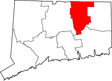 | |
| Other communities | ||
