Canton, Connecticut
| Canton, Connecticut | ||
|---|---|---|
| Town | ||
| ||
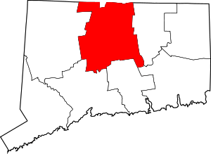
 Location within Hartford County, Connecticut | ||
| Coordinates: 41°51′42″N 72°54′33″W / 41.86167°N 72.90917°WCoordinates: 41°51′42″N 72°54′33″W / 41.86167°N 72.90917°W | ||
| Country | United States | |
| State | Connecticut | |
| NECTA | Hartford | |
| Region | Capitol Region | |
| Incorporated | 1806 | |
| Government | ||
| • Type | Selectman-town meeting | |
| • First Selectman | Leslee Hill | |
| Area | ||
| • Total | 25.0 sq mi (64.8 km2) | |
| • Land | 24.6 sq mi (63.7 km2) | |
| • Water | 0.4 sq mi (1.1 km2) | |
| Elevation | 397 ft (121 m) | |
| Population (2010) | ||
| • Total | 10,292 | |
| • Density | 410/sq mi (160/km2) | |
| Time zone | EST (UTC-5) | |
| • Summer (DST) | EDT (UTC-4) | |
| ZIP code | 06019, 06020, 06022, 06059 | |
| Area code(s) | 860 | |
| FIPS code | 09-12270 | |
| GNIS feature ID | 0213404 | |
| Website |
www | |
Canton is a town, incorporated in 1806, in Hartford County, Connecticut, United States. The population was 8,840 at the 2000 census and 10,292 as of the 2010 census.[1] It is bordered by Granby on the north, Simsbury on the east, Avon and Burlington on the south, New Hartford on the west, and Barkhamsted on the northwest. Running through it is the Farmington River. The town includes the villages of North Canton, Canton Center, Canton (Canton Valley), and Collinsville. In September 2007, Collinsville was ranked in Budget Travel magazine as one of the "Ten Coolest Small Towns In America".
History
At the Collins ax factory in Collinsville, Elisha Root invented the important industrial technique of die casting.
Points of interest
The Canton Historical Museum in Collinsville is located in a building of the former Collins Axe Company, founded by Samuel W. Collins and one of the first ax factories in the world. It displays a 19th-century general store, a post office, a printing press and blacksmith and barber shops. Vehicles, tools and farm implements are also exhibited, as well as a working railroad diorama, Victorian fashions, toys and dolls.[2]
The town is on the Farmington River, and Collinsville Canoe & Kayak is the largest specialty canoe and kayak store in New England. A rail trail also runs through the town.[3]
In the southeastern corridor of Canton, along U.S. Route 44, there is an open-air shopping center called The Shoppes at Farmington Valley which opened in 2004. The shopping center has 50 stores and restaurants, including Barnes & Noble, Dick's Sporting Goods, Kohl's, ShopRite, Old Navy, Talbots, and Panera Bread.
The Collinsville Renewable Energy Promotion Act (H.R. 316;113th Congress) was a piece of federal legislation that dealt specifically with Collinsville, CT. The bill was introduced into the United States House of Representatives of the 113th United States Congress by Representatives Elizabeth Esty. The bill directed the Federal Energy Regulatory Commission to reinstate two lapsed licenses and grant them to the town so that the town could restart two old dams and generate hydroelectric power.[4]
Geography
According to the United States Census Bureau, the town has a total area of 25.0 square miles (64.8 km2), of which 24.6 square miles (63.7 km2) is land and 0.42 square miles (1.1 km2), or 1.76%, is water.[1] The town center is a census-designated place (CDP) known as Canton Valley, with an area of 1.8 square miles (4.6 km2), all land.
Demographics
| Historical population | |||
|---|---|---|---|
| Census | Pop. | %± | |
| 1820 | 1,322 | — | |
| 1850 | 1,986 | — | |
| 1860 | 2,373 | 19.5% | |
| 1870 | 2,639 | 11.2% | |
| 1880 | 2,301 | −12.8% | |
| 1890 | 2,500 | 8.6% | |
| 1900 | 2,678 | 7.1% | |
| 1910 | 2,732 | 2.0% | |
| 1920 | 2,549 | −6.7% | |
| 1930 | 2,397 | −6.0% | |
| 1940 | 2,769 | 15.5% | |
| 1950 | 3,613 | 30.5% | |
| 1960 | 4,783 | 32.4% | |
| 1970 | 6,868 | 43.6% | |
| 1980 | 7,635 | 11.2% | |
| 1990 | 8,268 | 8.3% | |
| 2000 | 8,840 | 6.9% | |
| 2010 | 10,292 | 16.4% | |
| Est. 2014 | 10,345 | [5] | 0.5% |
As of the census[7] of 2000, there were 8,840 people, 3,516 households, and 2,492 families residing in the town. The population density was 359.7 people per square mile (138.9/km²). There were 3,616 housing units at an average density of 147.2 per square mile (56.8/km²). The racial makeup of the town was 97.15% White, 0.53% African American, 0.05% Native American, 0.72% Asian, 0.02% Pacific Islander, 0.49% from other races, and 1.04% from two or more races. Hispanic or Latino of any race were 1.28% of the population.
There were 3,516 households out of which 33.4% had children under the age of 18 living with them, 60.2% were married couples living together, 8.1% had a female householder with no husband present, and 29.1% were non-families. 24.3% of all households were made up of individuals and 8.0% had someone living alone who was 65 years of age or older. The average household size was 2.49 and the average family size was 2.98.
In the town the population was spread out with 25.4% under the age of 18, 4.2% from 18 to 24, 30.8% from 25 to 44, 27.7% from 45 to 64, and 11.9% who were 65 years of age or older. The median age was 40 years. For every 100 females there were 94.0 males. For every 100 females age 18 and over, there were 90.9 males.
The median income for a household in the town was $65,013, and the median income for a family was $80,533. Males had a median income of $49,980 versus $37,652 for females. The per capita income for the town was $33,151. About 1.9% of families and 2.7% of the population were below the poverty line, including 3.2% of those under age 18 and 0.5% of those age 65 or over. The median income for a household (Est. in 2009) has rose in the town of Canton due to an increase of home sales in the past decade. Canton was listed as one of the fastest growing towns in CT (circa 2006) and is steadily growing.
| Voter Registration and Party Enrollment as of October 25, 2005[8] | |||||
|---|---|---|---|---|---|
| Party | Active Voters | Inactive Voters | Total Voters | Percentage | |
| Republican | 1,859 | 2 | 1,861 | 29.08% | |
| Democratic | 1,797 | 1 | 1,798 | 28.09% | |
| Unaffiliated | 2,714 | 2 | 2,716 | 42.44% | |
| Minor Parties | 25 | 0 | 25 | 0.39% | |
| Total | 6,395 | 5 | 6,400 | 100% | |
Transportation
The town is served by U.S. Routes 44 and 202, as well as Connecticut Routes 177, 179, and 309. Commuter bus service to Hartford is provided by Connecticut Transit Hartford; a Park & Ride lot is on Old River Road in Collinsville. Intercity train and bus services are provided from Union Station in Hartford, and the nearest large airport is Bradley International Airport, about 13 miles (21 km) away in Windsor Locks.
Notable residents, past and present
- Lucien Barbour (1811–1880), congressman for Indiana, born in town
- Philemon Bliss (1813–1889), congressman for Ohio, born in town
- Samuel W. Collins (1802–1871), founder of the Collins Axe Factory for which Collinsville is named
- Danny Hoffman (1880–1922), Major League Baseball player, born in town
- Uriel Holmes (1764–1827), congressman for Connecticut, lived his later years and died in town
- Merrill I. Mills (1819–1882), mayor of Detroit, Michigan, born in town
- Anson Greene Phelps (1781–1853), industrialist and philanthropist, grew up in town
- William E. Simonds (1842–1903), US Civil War veteran, Medal of Honor recipient and congressman for Connecticut born in Collinsville
- David Vaudreuil (1966-), Major League Soccer player and coach, grew up in town.
References
- 1 2 "Geographic Identifiers: 2010 Demographic Profile Data (G001): Canton town, Hartford County, Connecticut". U.S. Census Bureau, American Factfinder. Retrieved November 26, 2012.
- ↑ Connecticut, Massachusetts & Rhode Island Tourbook 2007 Edition. (2007) p 57. AAA Publishing, Heathrow, Florida
- ↑ Collier, Christopher Percy, "10 Coolest Small Towns, Conn." article in Budget Travel, September 2007, retrieved November 12, 2008
- ↑ "H.R 316 - 113th Congress". United States Congress. Retrieved 12 April 2013.
- ↑ "Annual Estimates of the Resident Population for Incorporated Places: April 1, 2010 to July 1, 2014". Retrieved June 4, 2015.
- ↑ "Census of Population and Housing". Census.gov. Archived from the original on May 11, 2015. Retrieved June 4, 2015.
- ↑ "American FactFinder". United States Census Bureau. Archived from the original on 2013-09-11. Retrieved 2008-01-31.
- ↑ "Registration and Party Enrollment Statistics as of October 25, 2005" (PDF). Connecticut Secretary of State. Archived from the original (PDF) on 2006-09-23. Retrieved 2006-10-02.
External links
- Town of Canton official website
- Canton community website
- Canton Public Schools history
- Canton Historical Museum