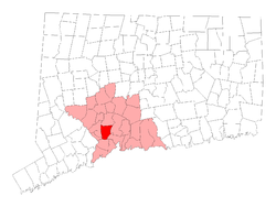
Woodbridge, Connecticut
| Woodbridge, Connecticut | ||
|---|---|---|
| Town | ||
 | ||
| ||
 Location in New Haven County, Connecticut | ||
| Coordinates: 41°21′15″N 73°00′41″W / 41.35417°N 73.01139°WCoordinates: 41°21′15″N 73°00′41″W / 41.35417°N 73.01139°W | ||
| Country | United States | |
| State | Connecticut | |
| NECTA | Bridgeport-Stamford | |
| Region | South Central Region | |
| Incorporated | 1784 | |
| Government | ||
| • Type | Selectman-town meeting | |
| • First selectman | Ellen Scalettar (D) | |
| • Selectmen |
| |
| Area | ||
| • Total | 19.2 sq mi (49.7 km2) | |
| • Land | 18.8 sq mi (48.8 km2) | |
| • Water | 0.4 sq mi (1.0 km2) | |
| Elevation | 348 ft (106 m) | |
| Population (2010) | ||
| • Total | 8,990 | |
| • Density | 470/sq mi (180/km2) | |
| Time zone | Eastern (UTC-5) | |
| • Summer (DST) | Eastern (UTC-4) | |
| ZIP code | 06525 | |
| Area code(s) | 203 | |
| FIPS code | 09-87700 | |
| GNIS feature ID | 0213539 | |
| Website |
www | |
Woodbridge is a town in New Haven County, Connecticut, United States. The population was 8,990 at the 2010 census.[1] It is one of the wealthiest towns in Connecticut, ranking 8th in the state per the 2010 US Census in terms of per capita income, and is home to many of the faculty of Yale University. The town center is listed on the National Register of Historic Places as Woodbridge Green Historic District.
History
Woodbridge was originally called "Amity", having been carved out of land originally belonging to New Haven and Milford as an independent parish in 1739. In 1742, the Rev. Benjamin Woodbridge was ordained in Amity, and it is after him that the modern town was named.
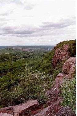
In 1661, the town was the location of one of the hideouts of the "Regicides" — three of the judges who signed the death warrant for King Charles I of England. The ruins of their hideout can be found on the nearby West Rock ridge, which runs along the town's eastern border.
Thomas Darling (1720–1789), a tutor at Yale College and later an entrepreneur in New Haven, moved to town in 1774. His home is now the Darling House Museum, operated by the Amity & Woodbridge Historical Association.[2] The original farms of Woodbridge were located in the area of the West River Valley known as "The Flats".
In the modern era, Woodbridge has undergone significant suburbanization.
Government
Woodbridge is governed by a 6-member Board of Selectmen.
In April 2006, Edward Maum Sheehy (Democrat) became First Selectman. Sheehy served on the Board of Selectmen for 27 years as a regular selectman. The Board of Selectmen elected Sheehy First Selectman by a 3 to 2 vote, along party lines, to replace Amey Marella (Republican), who stepped down to accept a job as Deputy Commissioner of the Connecticut Department of Environmental Protection. Before becoming First Selectwoman in 2001, Marella was an attorney with the United States Environmental Protection Agency. Edward Sheehy was reelected in May 2009 to another two-year term.
On April 22, 2013, Sheehy died suddenly at the age of 73 while still holding the selectman's office. He was actively seeking re-election in May. He was laid to rest on April 27, 2013.[3]
Recent First Selectmen elections
2015: Ellen Scalettar (Democrat) defeated Catherine Wick (Republican);
2013: Ellen Scalettar (Democrat) defeated Catherine Wick (Republican);
2013: Beth Heller (Democrat) elected by Board of Selectmen, 5 to 0;
2011: Edward Sheehy (Democrat) defeated Laura Ferrante-Fernandes (Republican);
2009: Edward Sheehy (Democrat) defeated Ken Colabella (Republican);
2007: Edward Sheehy (Democrat) defeated Chris Dickerson (Republican);
2006: Edward Sheehy (Democrat) elected by Board of Selectmen, 3 to 2;
2005: Amy Marrella (Republican) defeated Laurence Grotheer (Democrat);
2003: Amy Marrella (Republican) defeated Janice Horowitz (Democrat);
2001: Amy Marrella (Republican) defeated Susan Lora Jacobs (Democrat)
Education
Grammar school
Beecher Road School is the town's pre Kindergarten - Grade 6 school. It is run by a principal, Gina Prisco, and assistant principal Lisa Sherman.[4]
Middle school
As part of the Amity school system, Woodbridge shares a middle school with the town of Bethany, which is located north of Woodbridge.
High school
Woodbridge also shares the Amity Regional High School with the neighboring towns of Bethany and Orange. The high school is located in Woodbridge's town center area. It has recently undergone extensive renovations in order to accommodate the extra ninth grade coming in from all three towns.
Private schools
Woodbridge is home to Ezra Academy, a Jewish day school once attended by Natalie Portman.[5] Ezra Academy is a regional Jewish day school whose students reside in 21 towns throughout New Haven and Fairfield counties.
Geography
According to the United States Census Bureau, the town has a total area of 19.2 square miles (50 km2), of which 18.8 square miles (49 km2) is land and 0.4 square miles (1.0 km2) is water. The total area is 2.03% water.
Woodbridge is informally divided into two distinct parts—central Woodbridge, which occupies the western hilly side of town, and the area known as The Flats, which occupies the eastern slice of town bordering the less wealthy West Rock and the New Haven neighborhood of Westville.
Neighboring towns are Bethany to the north, Hamden to the east, New Haven to the southeast, Orange to the south, and Derby, Ansonia, and Seymour to the west.
Parks and hiking trails

Woodbridge is home to several organizations that protect undeveloped land and historic sites, including the Woodbridge Land Trust and the Woodbridge Park Association.[6] The town has an extensive system of preserved hiking trails open to the public, notably the 93-acre (380,000 m2) Alice Newton Street Memorial Park and the 22-acre (89,000 m2) Wepawaug Falls area. Some of the land has been donated by residents.[7]
Demographics
| Historical population | |||
|---|---|---|---|
| Census | Pop. | %± | |
| 1820 | 1,988 | — | |
| 1850 | 912 | — | |
| 1860 | 872 | −4.4% | |
| 1870 | 829 | −4.9% | |
| 1880 | 926 | 11.7% | |
| 1890 | 926 | 0.0% | |
| 1900 | 852 | −8.0% | |
| 1910 | 878 | 3.1% | |
| 1920 | 1,170 | 33.3% | |
| 1930 | 1,630 | 39.3% | |
| 1940 | 2,262 | 38.8% | |
| 1950 | 2,822 | 24.8% | |
| 1960 | 5,182 | 83.6% | |
| 1970 | 7,673 | 48.1% | |
| 1980 | 7,761 | 1.1% | |
| 1990 | 7,924 | 2.1% | |
| 2000 | 8,983 | 13.4% | |
| 2010 | 8,990 | 0.1% | |
| Est. 2014 | 8,925 | [8] | −0.7% |
As of the census[10] of 2000, there were 8,983 people, 3,103 households, and 2,553 families residing in the town. The population density was 477.0 people per square mile (184.2/km²). There were 3,189 housing units at an average density of 169.3 per square mile (65.4/km²). The racial makeup of the town was 91.34% White, 1.50% African American, 0.04% Native American, 5.10% Asian, 0.02% Pacific Islander, 0.60% from other races, and 1.39% from two or more races. 1.54% of the population were Hispanic or Latino of any race.
There were 3,103 households out of which 40.3% had children under the age of 18 living with them, 73.7% were married couples living together, 6.5% had a female householder with no husband present, and 17.7% were non-families. 15.3% of all households were made up of individuals and 9.8% had someone living alone who was 65 years of age or older. The average household size was 2.84 and the average family size was 3.17.
27.8% of the population was under the age of 18, 3.8% from 18 to 24, 22.5% from 25 to 44, 29.1% from 45 to 64, and 16.8% were 65 years of age or older. The median age was 43 years. For every 100 females there were 94.4 males. For every 100 females age 18 and over, there were 90.1 males.
The median income for a household in the town was $137,216, and the median income for a family was $155,694. Males had a median income of $105,632 versus $70,286 for females. The per capita income for the town was $69,179.[1] 2.3% of the population and 1.4% of families were below the poverty line. 2.7% of those under the age of 18 and 5.3% of those 65 and older were living below the poverty line.
| Voter registration and party enrollment as of October 25, 2005[11] | |||||
|---|---|---|---|---|---|
| Party | Active voters | Inactive voters | Total voters | ||
| Republican | 1,436 | 72 | 1,508 | ||
| Democratic | 1,767 | 125 | 1,892 | ||
| Unaffiliated | 2,951 | 253 | 3,204 | ||
| Minor Parties | 7 | 0 | 7 | ||
| Total | 3,766 | 138 | 3,904 | ||
Other
- The sulfur match was invented in Woodbridge by Samuel Beecher and Thomas Sanford in 1835.
- Woodbridge is often mentioned on the CW show Gilmore Girls as a rival of Stars Hollow, a fictional Connecticut town.
- Because of its proximity to Yale and its good school district, Woodbridge is considered one of the most educated towns in Connecticut. Woodbridge has one of the highest percentages of residents with graduate or professional degrees in Connecticut.
Notable people
- Guido Calabresi, judge on the U.S. Court of Appeals for the Second Circuit and Yale Law School professor
- Charles Edward Clark, jurist and politician
- David Gelernter, Yale University professor, noted author, painter and computer scientist
- Boone Guyton, businessman, author and WWII test pilot who flew the F4U Corsair and Vought V-173
- John Hollander, poet and literary critic
- Bun Lai, Sustainable sushi pioneering chef of Miya's
- David Aaron Kessler, former FDA commissioner, university medical dean
- Jeremy Leven, Hollywood screenwriter, director, producer, and novelist
- Jonathan Mostow, director of Terminator 3
- Paul Roessler, noted musician, composer, and producer
- Tarek Saleh, former stand-out football player for the University of Wisconsin and then the Carolina Panthers and Cleveland Browns of the NFL
- Louise Shaffer, actress, script writer, and author
- Maury Yeston, Tony Award-winning Broadway composer and lyricist. His works include Titanic, Grand Hotel, and Nine".
Notable locations
On the National Register of Historic Places
- Darling House Museum - added to the National Register of Historic Places in 1979
- Woodbridge Green Historic District - added to the National Register of Historic Places in 2003
References
- 1 2 "Profile of General Population and Housing Characteristics: 2010 Demographic Profile Data (DP-1): Woodbridge town, New Haven County, Connecticut". U.S. Census Bureau, American Factfinder. Retrieved October 1, 2012.
- ↑ "History" web page, Amity & Woodbridge Historical Association website, retrieved February 6, 2008
- ↑ "Obituary: Woodbridge First Selectman Edward Maum Sheehy, 73". Bethwood, Connecticut Patch.
- ↑ "Woodbridge School District".
- ↑ Spring 2005 Ezra Academy pamphlet
- ↑ http://www.woodbridgect.org/content/136/default.aspx
- ↑ http://www.woodbridgeparks.org/LandDonations.pdf
- ↑ "Annual Estimates of the Resident Population for Incorporated Places: April 1, 2010 to July 1, 2014". Retrieved June 4, 2015.
- ↑ "Census of Population and Housing". Census.gov. Retrieved June 4, 2015.
- ↑ "American FactFinder". United States Census Bureau. Retrieved 2008-01-31.
- ↑ "Registration and Party Enrollment Statistics as of October 25, 2005" (PDF). Connecticut Secretary of State. Archived from the original (PDF) on 2008-03-07. Retrieved 2006-10-02.
External links
| Wikimedia Commons has media related to Woodbridge, Connecticut. |
- Official website
- Woodbridge Historical Society
- Woodbridge Public Library
- Woodbridge Public Schools
- Beecher Road School
- Amity Regional School District
- Woodbridge Fire Department
- Woodbridge Town News
- http://westrivervalley.wordpress.com/
- The Amity Star, a newspaper that covered Woodbridge and Bethany in the early 1950s

Municipalities and communities of New Haven County, Connecticut, United States | ||
|---|---|---|
| Cities | 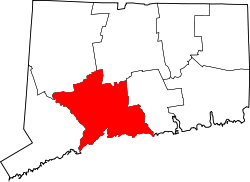 | |
| Towns |
*Consolidated borough and town | |
| Borough | ||
| Other communities | ||