Norfolk, Connecticut
| Norfolk, Connecticut | ||
|---|---|---|
| Town | ||
| ||
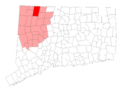 Location in Lichfield County, Connecticut | ||
| Coordinates: 41°59′01″N 73°11′47″W / 41.98361°N 73.19639°WCoordinates: 41°59′01″N 73°11′47″W / 41.98361°N 73.19639°W | ||
| Country | United States | |
| State | Connecticut | |
| NECTA | None | |
| Region | Litchfield Hills | |
| Incorporated | 1758 | |
| Government | ||
| • Type | Selectman-town meeting | |
| • First selectman | Susan M. Dyer (D) | |
| • Selectman | Leo F. Colwell, Jr. (D) | |
| • Selectman | Joshua N. DeCerbo (R) | |
| Area | ||
| • Total | 46.4 sq mi (120.2 km2) | |
| • Land | 45.3 sq mi (117.4 km2) | |
| • Water | 1.1 sq mi (2.8 km2) | |
| Elevation | 1,230 ft (375 m) | |
| Population (2010)[1] | ||
| • Total | 1,787 | |
| • Density | 37/sq mi (14/km2) | |
| Time zone | Eastern (UTC-5) | |
| • Summer (DST) | Eastern (UTC-4) | |
| ZIP code | 06058 | |
| Area code(s) | 860 | |
| FIPS code | 09-53470 | |
| GNIS feature ID | 0213476 | |
| Website | Official website | |

Norfolk (local /ˈnɔːrfɔːrk/)[2] is a town in Litchfield County, Connecticut, United States. The population was 1,787 at the 2010 census.
Norfolk is perhaps best known as the site of the Yale Summer School of Music – Norfolk Chamber Music Festival, which hosts an annual chamber music concert series in "the Music Shed," a performance hall located on the Ellen Battell Stoeckel estate to the west of the village green. Norfolk has important examples of regional architecture, notably the Village Hall (now Infinity Hall, a shingled 1880s Arts-and-Crafts confection, with an opera house upstairs and storefronts at street level); the Norfolk Library (a shingle-style structure, designed by George Keller, ca 1888/1889); and over thirty buildings, in a wide variety of styles, designed by Alfredo S. G. Taylor (of the New York firm Taylor & Levi) in the four decades before the Second World War.
History
Norfolk was first settled in 1744 and incorporated in 1758, later than most surrounding towns because of the dense woods, rocky soil and high elevation. Originally a farming community, nineteenth-century Norfolk saw the rise of numerous small factories, many of which fabricated tools and farming implements from local iron ore, and mills, which took advantage of fast-flowing mountain streams.
By the late 19th century, however, rail connections to New York, Hartford, Pittsburgh and Boston gave visitors ready access to Norfolk's cool summers and clean air, and Norfolk soon evolved into a fashionable resort as its small industry declined. The town has ever since had a bustling "summer colony." Like several other towns in the Litchfield Hills, Norfolk has, in more recent years, developed a sizable population of "weekenders" from New York City and environs.
The town of Norfolk celebrated its semiquincentennial (250th anniversary) on August 1–2, 2008.
Geography
According to the United States Census Bureau, the town has a total area of 46.4 square miles (120 km2), of which, 45.3 square miles (117 km2) of it is land and 1.1 square miles (2.8 km2) of it (2.37%) is water. The town is located in the Litchfield Hills portion of the Appalachian mountain range. Norfolk's elevation is 1,230 feet above sea level, and the town is sometimes called "the Icebox of Connecticut" for its severe winters and particularly cool summers.
The town is bordered on the west by Canaan, Connecticut and North Canaan, Connecticut; on the north by New Marlborough, Massachusetts and Sandisfield, Massachusetts; on the east by Colebrook, Connecticut and Winchester, Connecticut; and on the south by Goshen, Connecticut.
Principal communities
- Norfolk Center
- North Norfolk
- South Norfolk
- West Norfolk
State parks
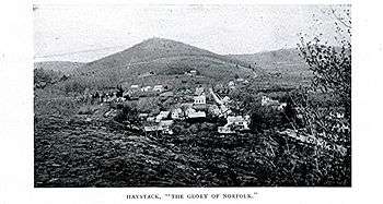
Norfolk is home to three state parks: Dennis Hill State Park, which includes the remnants of a lavish summer pavilion designed by Alfredo Taylor; Haystack Mountain State Park, with a stone tower at the mountain's summit; and Campbell Falls State Park Reserve, with an approximately 100-foot (30 m) natural waterfall.
Demographics
| Historical population | |||
|---|---|---|---|
| Census | Pop. | %± | |
| 1820 | 1,422 | — | |
| 1850 | 1,643 | — | |
| 1860 | 1,803 | 9.7% | |
| 1870 | 1,641 | −9.0% | |
| 1880 | 1,418 | −13.6% | |
| 1890 | 1,546 | 9.0% | |
| 1900 | 1,614 | 4.4% | |
| 1910 | 1,541 | −4.5% | |
| 1920 | 1,229 | −20.2% | |
| 1930 | 1,298 | 5.6% | |
| 1940 | 1,333 | 2.7% | |
| 1950 | 1,572 | 17.9% | |
| 1960 | 1,827 | 16.2% | |
| 1970 | 2,073 | 13.5% | |
| 1980 | 2,156 | 4.0% | |
| 1990 | 2,060 | −4.5% | |
| 2000 | 1,660 | −19.4% | |
| 2010 | 1,709 | 3.0% | |
| Est. 2014 | 1,655 | [3] | −3.2% |
As of the census[5] of 2000, there were 1,660 people, 676 households, and 461 families residing in the town. The population density was 36.6 people per square mile (14.1/km²). There were 871 housing units at an average density of 19.2 per square mile (7.4/km²). The racial makeup of the town was 97.11% White, 0.48% African American, 0.24% Native American, 0.54% Asian, 0.60% from other races, and 1.02% from two or more races. Hispanic or Latino of any race were 0.96% of the population.
There were 676 households out of which 28.0% had children under the age of 18 living with them, 58.3% were married couples living together, 6.5% had a female householder with no husband present, and 31.7% were non-families. 24.6% of all households were made up of individuals and 10.4% had someone living alone who was 65 years of age or older. The average household size was 2.44 and the average family size was 2.92.
In the town the population was spread out with 23.7% under the age of 18, 4.3% from 18 to 24, 29.2% from 25 to 44, 29.0% from 45 to 64, and 13.8% who were 65 years of age or older. The median age was 41 years. For every 100 females there were 96.4 males. For every 100 females age 18 and over, there were 97.0 males.
The median income for a household in the town was $58,906, and the median income for a family was $67,500. Males had a median income of $41,654 versus $36,442 for females. The per capita income for the town was $34,020. About 1.8% of families and 4.1% of the population were below the poverty line, including 4.3% of those under age 18 and 6.2% of those age 65 or over.
Transportation
The main thoroughfares of the town are Route 44 (going east-west, and also known as Greenwoods Road) and Route 272 (going north-south, with 272N also known as North Street and 272S also known as Litchfield Road).
Notable locations

- Blackberry River Inn - built in 1763 and listed on the National Register of Historic Places.
- Gould House - listed on the National Register of Historic Places.
- Haystack Mountain Tower - built in 1929 and listed on the National Register of Historic Places in 1993.
- Hillside - listed on the National Register of Historic Places.
- Infinity Hall - an 1883 opera house and concert hall.
- Low House - listed on the National Register of Historic Places.
- Norfolk Library - built in 1888-89, a contributing property in Norfolk Historic District.
- Rectory and Church of the Immaculate Conception - built in 1924 and added to the National Register of Historic Places in 1982.
- Rockwell House - listed on the National Register of Historic Places.
- Tom Thumb House - listed on the National Register of Historic Places.
- World War I Memorial - listed on the National Register of Historic Places.
Notable people, past and present
Notable residents have included inventor Michael I. Pupin (1858-1935), publisher James Laughlin (1914-1997), critic Brendan Gill (1914-1997) and Secretary of the Treasury William Windom (1827-1891). Mark Twain was a sometime summer visitor to Norfolk, and a stained glass window at the Church of the Transfiguration (Episcopal) commemorates his wife, Olivia Langdon Clemens. The town of Norfolk owes much to the benefactions, over the course of several generations, of the extended Battell family, which made a large fortune in the early 19th century from cheese, trading and speculation in Western lands. Notable members of this family include Joseph Battell (1774-1841), the merchant who founded the fortune and built the family's imposing seat (known as "Whitehouse") overlooking the Village Green; Robbins Battell, who was largely responsible for positioning Norfolk as a summer resort; Miss Isabella Eldridge, who built and endowed the Norfolk Library; and Ellen Battell Stoeckel, whose charitable trust provides the campus for, and helps underwrite, the Yale Summer School of Music – Norfolk Chamber Music Festival. William Henry Welch (1850-1934), the founding dean of the Johns Hopkins University School of Medicine, was born in Norfolk, scion of a family of Norfolk physicians. Hayden Carruth (1921-2008) published a book of "Norfolk Poems" in 1962, and these poems mention numerous Norfolk sites and residents. In The Lightning Keeper, a 2006 novel by Starling Lawrence, the town of Beecher's Bridge is based on Norfolk, to which the author's family has longstanding ties, and some of the novel's characters echo actual Norfolkians of the late 19th and early 20th century. Joseph Emerson, minister and theologian, was born here in 1821.[6]
Climate
This climatic region is typified by large seasonal temperature differences, with warm to hot (and often humid) summers and cold (sometimes severely cold) winters. According to the Köppen Climate Classification system, Norfolk has a humid continental climate, abbreviated "Dfb" on climate maps.[7]
References
- ↑ U.S. Census Bureau Population Estimates
- ↑ Kelly, Michael (2014). "You Say Norfork, I Say Norfolk." Norfolk Now.
- ↑ "Annual Estimates of the Resident Population for Incorporated Places: April 1, 2010 to July 1, 2014". Retrieved June 4, 2015.
- ↑ "Census of Population and Housing". Census.gov. Retrieved June 4, 2015.
- ↑ "American FactFinder". United States Census Bureau. Retrieved 2008-01-31.
- ↑ "Joseph Emerson". www.findgrave.com. Find A Grave Inc. Retrieved December 30, 2015.
- ↑ Climate Summary for Norfolk, Connecticut, weatherbase.com; accessed January 1, 2015.
- A. Havemeyer & R. Dance, Alfredo Taylor in Norfolk (Norfolk: Norfolk Hist. Soc., 2005)
- A. Havemeyer & R. Dance, The Magnificent Battells (Norfolk: Norfolk Hist. Soc., 2006)
- T.W. Crissey, History of Norfolk, Litchfield County, Connecticut (Everett, MA: Massachusetts Pub. Co., 1900)
- A.V. Waldecker [ed.], Norfolk, Connecticut 1900-1975 (Norfolk: Norfolk Bicen. Comm., 1976)
External links
- The Norfolk Library
- Norfolk Historical Society
- Description of Norfolk Ct circa 1935
- Town website
- Northwest Connecticut Convention & Visitors Bureau

Municipalities and communities of Litchfield County, Connecticut, United States | ||
|---|---|---|
| Consolidated city | 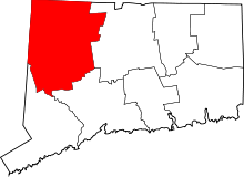 | |
| Towns | ||
| Non-consolidated city |
| |
| Boroughs | ||
| Other communities | ||