Kent, Connecticut
| Kent, Connecticut | ||
|---|---|---|
| Town | ||
| ||
 Location in Litchfield County, Connecticut | ||
| Coordinates: 41°43′54″N 73°27′09″W / 41.73167°N 73.45250°WCoordinates: 41°43′54″N 73°27′09″W / 41.73167°N 73.45250°W | ||
| Country | United States | |
| State | Connecticut | |
| NECTA | None | |
| Region | Northwestern Connecticut | |
| Incorporated | 1739 | |
| Government | ||
| • Type | Selectman-town meeting | |
| • First selectman | Bruce K. Adams (D) | |
| • Selectman | Michael V. Valkenburg (D) | |
| • Selectman | Mary C. Williams (R) | |
| Area | ||
| • Total | 49.6 sq mi (128.5 km2) | |
| • Land | 48.5 sq mi (125.5 km2) | |
| • Water | 1.1 sq mi (2.9 km2) | |
| Elevation | 466 ft (142 m) | |
| Population (2005)[1] | ||
| • Total | 2,962 | |
| • Density | 61/sq mi (24/km2) | |
| Time zone | Eastern (UTC-5) | |
| • Summer (DST) | Eastern (UTC-4) | |
| ZIP code | 06757, 06785 | |
| Area code(s) | 860 | |
| FIPS code | 09-40290 | |
| GNIS feature ID | 0213446 | |
| Website |
www | |

Kent is a town in Litchfield County, Connecticut, alongside the border with New York. The population was 2,858 at the 2000 census. The town is home to three boarding schools: South Kent School, Kent School and The Marvelwood School. The Schaghticoke Indian Reservation is also located within town borders.
History
The Town of Kent was sectioned in 1737 and settled about 1739.[2] The community was important in the growth of iron production.
Geography
Kent is in Litchfield County. Its location is 41°43′29″N 73°28′39″W / 41.72472°N 73.47750°W. According to the United States Census Bureau, the town has a total area of 49.6 square miles (128 km2), of which, 48.5 square miles (126 km2) of it is land and 1.1 square miles (2.8 km2) of it (2.26%) is water. Bulls Bridge, one of two covered bridges open to vehicles in Connecticut, is located in the town. The town is bisected by the Housatonic River. The western half contains Macedonia Brook State Park, the Schaghticoke Indian Reservation, as well as a section of the Appalachian Trail.
Principal communities
- Bulls Bridge
- Flanders
- Kent center
- Kent Furnace
- Macedonia
- North Kent
- South Kent (has its own post office)
- Schaghticoke Indian Reservation
Points of interest
Macedonia Brook State Park
Macedonia Brook State Park was first opened in 1918 with a donation of 1,552 acres (6.28 km2) from White Memorial Foundation of Litchfield. Since then, it has now grown to a size of 2,300 acres (9.3 km2) and is used for outdoor recreation throughout the year.
Besides the pure beauty of Appalachia, the park also boasts extensive trails, campgrounds, a venue for large group picnics, a small hilltop lake and of course, Macedonia Brook. Visitors can also take advantage of the numerous grills set up around the park. From peaks on the Blue Trail, hikers can take in fantastic views of the Catskill Mountains and the Taconic Mountains.
Kent Falls State Park
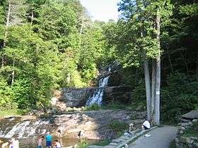
Kent Falls State Park is often called “The Jewel of the Inland Parks” with its scenic view of 17 different waterfalls. The falls are fed by wetlands which are located in Warren, and empties directly into the Housatonic River, which is across the street from the park.
A trail winds a quarter of a mile up along the falls and although it is not difficult to walk it is steep, rising 250 feet (76 m) in just a quarter mile. In 2006 a 1.1 million dollar trail renovation was finished which provided new viewing platforms and a redesigned trail. Swimming was at one time allowed along the entire length of the falls but due to a number of serious accidents, and large scale damage to the natural environment which thrives in the park all of the area along the water above the bottom level is now closed by state law.
The park is designated as a Trout Park and is stocked with trout from the state's hatcheries. Due to the Trout Park designation the daily creel limit in the park is two fish.
Bulls Bridge
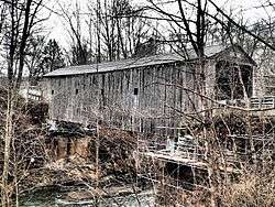
Bull's Bridge is one of three remaining covered bridges in Connecticut dating from the 19th century. George Washington crossed the Housatonic River near the site of the present bridge in 1781.
Sloane-Stanley Museum
A museum featuring the studio and antique collections of Eric Sloane.
Connecticut Antique Machinery Association
A museum dedicated to antique machinery, as the name implies. One notable exhibit is its 3 ft (914 mm) narrow gauge[3] railroad, which features an operating steam locomotive.
Demographics
| Historical population | |||
|---|---|---|---|
| Census | Pop. | %± | |
| 1820 | 1,956 | — | |
| 1850 | 1,848 | — | |
| 1860 | 1,855 | 0.4% | |
| 1870 | 1,744 | −6.0% | |
| 1880 | 1,622 | −7.0% | |
| 1890 | 1,383 | −14.7% | |
| 1900 | 1,220 | −11.8% | |
| 1910 | 1,122 | −8.0% | |
| 1920 | 1,086 | −3.2% | |
| 1930 | 1,054 | −2.9% | |
| 1940 | 1,245 | 18.1% | |
| 1950 | 1,392 | 11.8% | |
| 1960 | 1,686 | 21.1% | |
| 1970 | 1,990 | 18.0% | |
| 1980 | 2,505 | 25.9% | |
| 1990 | 2,918 | 16.5% | |
| 2000 | 2,858 | −2.1% | |
| 2010 | 2,979 | 4.2% | |
| Est. 2014 | 2,910 | [4] | −2.3% |
As of the census[6] of 2000, there were 2,858 people, 1,143 households, and 744 families residing in the town. The population density was 59.0 people per square mile (22.8/km²).were 1,463 housing units at an average density of 30.2 per square mile (11.7/km²). The racial makeup of the town was 95.77% White, 0.56% Black or African American, 0.77% Native American, 0.98% Asian, 0.03% Pacific Islander, 0.70% from other races, and 1.19% from two or more races. 2.52% of the population were Hispanic or Latino of any race.The top 5 ethnic groups in Kent are · English - 19% · Irish - 16% · German - 14% · Italian - 7% · Scottish - 5%
There were 1,143 households out of which 28.6% had children under the age of 18 living with them, 55.6% were married couples living together, 6.7% had a female householder with no husband present, and 34.9% were non-families. 28.3% of all households were made up of individuals and 12.6% had someone living alone who was 65 years of age or older. The average household size was 2.43 and the average family size was 2.99.
In the town the population was spread out with 22.8% under the age of 18, 5.2% from 18 to 24, 26.3% from 25 to 44, 27.8% from 45 to 64, and 17.8% who were 65 years of age or older. The median age was 43 years. For every 100 females there were 93.9 males. For every 100 females age 18 and over, there were 90.6 males.
The median income for a household in the town was $53,906, and the median income for a family was $66,065. Males had a median income of $46,343 versus $31,493 for females. The per capita income for the town was $38,674. About 0.1% of families and 3.2% of the population were below the poverty line, including none of those under age 18 and 10.8% of those age 65 or over.
| Voter registration and party enrollment as of October 25, 2005[7] | |||||
|---|---|---|---|---|---|
| Party | Active voters | Inactive voters | Total voters | Percentage | |
| Democratic | 602 | 26 | 628 | 29.68% | |
| Republican | 570 | 20 | 590 | 27.88% | |
| Unaffiliated | 839 | 59 | 898 | 42.44% | |
| Minor Parties | 0 | 0 | 0 | 0.0% | |
| Total | 2,011 | 105 | 2,116 | 100% | |
Transportation
Route 7 is the main north-south highway in the town, while Route 341 is the main east-west highway.
Notable people
- William H. Armstrong, author of Sounder
- Joe Bouchard, founding member of rock group Blue Öyster Cult
- James Burnham, American political theorist, spent his final years in Kent, where he died
- Ted Danson, actor and graduate of Kent School
- Oscar De la Renta, fashion designer
- Brendan Fraser, actor
- Adam Kennedy actor, author, painter, died in Kent
- Henry Kissinger, former U.S. Secretary of State, has a home in town and often does television interviews from Kent
- Trudie Lamb-Richmond, Schaghticoke elder, former Tribal Chairwoman, American Indian activist, author, educator, cultural leader, Storyteller, and tribal historian
- Patti LuPone, singer and actress
- Seth MacFarlane animator, TV producer and director and voice actor who created Family Guy, Cleveland Show, and American Dad!, born in Kent, as well as his sister Rachael MacFarlane
- Edmund Morris, Pulitzer Prize-winning writer
- Lynn Redgrave, actress
- Brooke Stevens, novelist
- Lana del Rey, singer and graduate of Kent School
References
- ↑ U.S. Census Bureau Population Estimates
- ↑ Kent Historical Society -- 275th anniversary celebration October 2014
- ↑ "The Connecticut Antique Machinery Association"
- ↑ "Annual Estimates of the Resident Population for Incorporated Places: April 1, 2010 to July 1, 2014". Retrieved June 4, 2015.
- ↑ "Census of Population and Housing". Census.gov. Retrieved June 4, 2015.
- ↑ "American FactFinder". United States Census Bureau. Retrieved 2008-01-31.
- ↑ "Registration and Party Enrollment Statistics as of October 25, 2005" (PDF). Connecticut Secretary of State. Archived from the original (PDF) on 2006-09-23. Retrieved 2006-10-02.
External links
| Wikimedia Commons has media related to Kent, Connecticut. |
- Kent Center School
- KenMont & KenWood Camps
- Town Website
- News on Kent
- Kent Chamber of Commerce Website
- Weantinoge Heritage Land Trust website
- Northwest Connecticut Convention and Visitors Bureau
- Northwest Connecticut Arts Council
- Northwestern Connecticut Community College in Winsted
- Horses in Kent
- Geer Mountain Overlook South
- Bull's Bridge pictures and videos of high water
- Schaghticoke Tribal Nation
- Connecticut Antique Machinery Association

Municipalities and communities of Litchfield County, Connecticut, United States | ||
|---|---|---|
| Consolidated city | 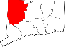 | |
| Towns | ||
| Non-consolidated city |
| |
| Boroughs | ||
| Other communities | ||