Alberta Highway 4
| ||||
|---|---|---|---|---|
 | ||||
| Route information | ||||
| Length: | 103.4 km[1] (64.2 mi) | |||
| History: |
1912 (Sunshine Trail) 1947 (paved) 2009 (twinning complete) | |||
| Major junctions | ||||
| South end: |
| |||
|
| ||||
| North end: |
| |||
| Location | ||||
| Specialized and rural municipalities: | Warner No. 5 County, Lethbridge County | |||
| Major cities: | Lethbridge | |||
| Towns: | Milk River | |||
| Villages: | Coutts, Warner | |||
| Highway system | ||||
|
Provincial highways in Alberta
| ||||

.svg.png)
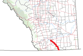
Alberta Provincial Highway No. 4 is a 103 km (64 mi) north-south highway in southern Alberta, Canada, connecting Lethbridge to Interstate 15 via the border community of Coutts. It is a lightly travelled divided highway, but is designated as a core route in the National Highway System and forms part of the critical CANAMEX Corridor linking Canada to the United States and Mexico. Between Lethbridge and Stirling, Highway 4 is signed as part of the Red Coat Trail, a route stretching from southern Alberta into Manitoba. At its south terminus, Interstate 15 connects Alberta with the American cities of Salt Lake City, Las Vegas, Los Angeles, and San Diego.
Highway 4 runs from Alberta's border with Montana through gentle rolling hills and farmlands in the south of the province, through Milk River, Warner and Stirling, to Crowsnest Trail on the east side of Lethbridge. The route was first called the Sunshine Trail in 1912, paralleling a historic branch of the Canadian Pacific Railway that dates back to the late 1800s. Though traffic volume is light, Alberta Transportation has proposed a bypass of Lethbridge that would link Highway 4 to a newly aligned Highway 3 north of Lethbridge, making the CANAMEX Corridor free-flowing from Coutts to Fort Macleod.
Route description
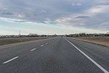
A component of the National Highway System,[2] Highway 4 is a four-lane divided highway, constructed parallel to a line of the Canadian Pacific Railway.[3] Outside of Lethbridge and Coutts, the highway has a posted speed limit of 110 km/h (68 mph), like most other major divided highways in Alberta outside of urban areas.[4]
Interstate 15 becomes Highway 4 as it crosses the international border between Montana and Alberta into the Village of Coutts.[3] The highway winds north out of Coutts alongside the railway to a three-way intersection with Highway 501 which leads west to Del Bonita. The two highways continue concurrently to the north, briefly paralleling Milk River. The concurrency ends and Highway 501 splits to the east into the community of Milk River, becoming Railway Street, while Highway 4 continues north across the river to bypass the town.[5][6][7]
Highway 4 continues 16 km (9.9 mi) north to Warner, which it bypasses to the east;[7][8] the original alignment of the highway was directly through the community.[9] From Warner, Highway 36 splits to the north en route to Taber and Vauxhall. Highway 4 continues north-northwest to the Hamlet of New Dayton and an intersection with Highway 52 at Craddock, leading west to Raymond. Further north, Stirling Lake and the town of Stirling lie immediately west of Highway 4. New pavement was built east of Stirling to allow the divided highway to curve smoothly to the northeast, and a portion of the former two lane road remains.[10] Just north of Stirling, Highway 61 splits to the east leading to Foremost. North of Stirling, the community of Wilson Siding lies at the intersection of Highway 4 and Highway 845. Highway 4 reaches Lethbridge and curves due west across the CPR tracks becoming 24 Avenue South.[11]
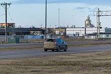
In Lethbridge, the highway turns north onto 43rd Street as a major arterial road with a speed limit of 70 km/h (43 mph). It intersects the major east-west arterial routes of 20 Avenue and South Parkside Drive in south Lethbridge before crossing the Canadian Pacific Railway tracks a final time, then ends at an intersection with Crowsnest Trail.[12] With only four traffic lights, it provides an alternative to the busy Mayor Magrath Drive, the main north-south route in Lethbridge, which has a dozen sets of lights over the same distance.[11] The section of 43rd Street near 6 Avenue South is the busiest part of Highway 4, with nearly 20,000 vehicles per day in 2015. Outside of Lethbridge, the highway sees well under 10,000 vehicles per day, with numbers steadily decreasing closer to the United States border.[13]
History
Like many other main highways in southern Alberta, the alignment of Highway 4 is based on an existing railway.[14] In the late 1890s, a railway was constructed between Lethbridge and Coutts by the Alberta Railway and Coal Company, who then extended the route to Great Falls, Montana.[15] A spur to the southwest from Stirling to Cardston was also built. A trail developed paralleling the railroad, eventually evolving by 1912 into a gravel road known as the Sunshine Trail.[16][17] From Lehbridge, it followed the railway line on a southeasterly heading before turning east along Township Road 54 at New Dayton.[9] It then followed present day Highway 36 due south through Warner, before turning back east toward the railway north of Milk River, before following it through the town and into Coutts.[9] By 1947 the road had been paved, and designated as Highway 4 the following decade.[16][18] Prior to the construction of 43rd Street, the former alignment of Highway 4 in Lethbridge was along Mayor Magrath Drive, cosigned with Highway 5 to 3 Avenue in south Lethbridge, which was then Highway 3.[19] It was later signed as 24 Avenue past Highway 5 (Mayor Magrath Drive), becoming Scenic Drive and continuing in a northwest direction to Highway 3 near downtown.[20]
In 1992, twinning of 43rd Street in Lethbridge was completed, although it did not carry the Highway 4 designation at this time.[21] Plans to upgrade the CANAMEX Corridor in southern Alberta to a divided highway were confirmed by 1989, and reiterated as a priority by annual reports published by Alberta Transportation through the 1990s. The highway was the southern most component of what was then called the Export Highway, which also included Highways 2 and 3.[22] By 1996, initial work had begun on twinning of a 13 km (8.1 mi) section north of Coutts, and a $26 million commitment was collectively made by Alberta to a group of projects that included the twinning of Highway 4 in Lethbridge.[23][24] By 1998, a 12 km (7.5 mi) section south of Lethbridge to Highway 845 had been completed.[25] The final sections were completed in the early 2000s, except for a $59 million bypass of Milk River that was completed in 2009.[26]
In September 1999, Highway 4 and Interstate 15 in Montana, being the main highways between the cities of Helena and Lethbridge, were designated the First Special Service Force Memorial Highway.[27] The route was travelled in 1942 by Canadian volunteers of the force to join their American counterparts for training at Fort William Henry Harrison.[27]
Future bypass
Alberta Transportation has proposed the construction of a freeway bypass of Lethbridge, tentatively called Highway 4X. In combination with proposed bypasses of Fort Macleod, Claresholm and Nanton, the project would eliminate all traffic lights on the CANAMEX Corridor in southern Alberta.[1][28] In a study completed by Stantec, the recommended alignment of the route would split from the existing Highway 4 southeast of Lethbridge between Range Roads 210 and 205, approximately equidistant between Lethbridge and Wilson Siding.[28]:11 The divided highway would proceed due north, crossing Highway 3 between Lethbridge and Coaldale to a second new highway north of the city serving as a realigned Lethbridge bypass of Highway 3 between Township Roads 94 and 100. The alternative to a bypass project would be a significant upgrading of Crowsnest Trail to a freeway standard through Lethbridge. This upgrade would potentially require relocation of the adjacent CPR railway line, and significant demolition of adjacent properties. During the study, the city of Lethbridge indicated that this disruptive alignment would be rejected, hence the need for a bypass outside of city limits to the east and north.[28]:5 In 2005, the entire project was estimated to cost $546 million.[28]:12
Major intersections
| Rural/specialized municipality | Location | km[7] | mi | Destinations | Notes | ||
|---|---|---|---|---|---|---|---|
| County of Warner No. 5 | Coutts | 0 | 0.0 | Canada – United States border | |||
| 1.3 | 0.81 | ||||||
| | 16.1 | 10.0 | South end of Hwy 501 concurrency | ||||
| Milk River | 19.2 | 11.9 | North end of Hwy 501 concurrency South Milk River access (former Hwy 4 alignment) | ||||
| 19.5 | 12.1 | Crosses Milk River | |||||
| 21.5 | 13.4 | Railway Street to | North Milk River access (former Hwy 4 alignment) | ||||
| Warner | 37.8 | 23.5 | |||||
| | 46.2 | 28.7 | |||||
| New Dayton | 59.2 | 36.8 | Range Road 184 | New Dayton access road | |||
| | 65.8 | 40.9 | |||||
| Stirling | 74.2 | 46.1 | |||||
| Lethbridge County | | 86.4 | 53.7 | ||||
| | 88.8 | 55.2 | |||||
| City of Lethbridge | 99.5 | 61.8 | 24th Avenue S to 43rd Street | Former alignment of Hwy 4 continues west Hwy 4 turns north along 43rd Street | |||
| 101.0 | 62.8 | South Parkside Drive | |||||
| 102.7 | 63.8 | ||||||
| 103.4 | 64.2 | Red Coat Trail follows Hwy 3 west | |||||
| Continues as 43rd Street to Hwy 843 | |||||||
1.000 mi = 1.609 km; 1.000 km = 0.621 mi
| |||||||
See also
References
- 1 2 "2016 Provincial Highway 1-216 Progress Chart" (PDF). Alberta Transportation. March 2016. Archived (PDF) from the original on November 12, 2016. Retrieved November 12, 2016.
- ↑ "National Highway System". Transport Canada. December 13, 2009. Archived from the original on August 6, 2011. Retrieved March 17, 2011.
- 1 2 Alberta Official Road Map (Map) (2010 ed.). Alberta Tourism, Parks and Recreation. § N–6, N-7, O–7.
- ↑ Davison, Janet (August 29, 2014). "Is it time for higher speed limits on Canada's highways". CBC News. Archived from the original on April 12, 2016. Retrieved October 24, 2016.
- ↑ "CANAMEX Trade Corridor". Alberta Transportation. Retrieved November 4, 2016.
Many projects have contributed to the overall efficiency of the CANAMEX/North-South Trade Corridor... [including] the completion of the Milk River bypass along Highway 4...
- ↑ Google (May 2016). "Highway 4 Bypassing Milk River, Alberta". Google Street View. Retrieved October 24, 2016.
- 1 2 3 Google (November 13, 2016). "Highway 4 in southern Alberta" (Map). Google Maps. Google. Retrieved November 13, 2016.
- ↑ Google (May 2016). "Highway 4 Bypassing Warner, Alberta". Google Street View. Retrieved October 24, 2016.
- 1 2 3 "Map of the province of Alberta, Canada.". Peel's Prairie Provinces - University of Alberta. Edmonton: Department of Lands and Mines. 1931. Retrieved December 3, 2016.
- ↑ Google (November 4, 2016). "Aerial view - Highway 4 near Stirling" (Map). Google Maps. Google. Retrieved November 4, 2016.
- 1 2 Google (October 28, 2016). "Highway 4 in Lethbridge" (Map). Google Maps. Google. Retrieved October 28, 2016.
- ↑ Google (May 2016). "Highway 4 in Lethbridge". Google Street View. Retrieved October 24, 2016.
- ↑ "Alberta Highways 1 to 986 - Traffic Volume History 2006 - 2015" (PDF). Alberta Transportation. February 18, 2016. p. 25. Retrieved October 25, 2016.
- ↑ "Calgary District, Alberta". Peel's Prairie Provinces - University of Alberta. Ottawa: Topographical Survey of Canada, Department of the Interior. February 1926. Retrieved October 26, 2016.
- ↑ "Alberta Railway and Coal Company, St. Mary's River". Public Archives of Canada. 2005 [First published 1883]. Retrieved November 4, 2016 – via Atlas of Alberta Railways, University of Alberta Press.
- 1 2 Cashman, Tony (1990). A History of Motoring in Alberta (3rd ed.). Edmonton: Alberta Motor Association.
- ↑ "Motor roads in Western Canada and United States connections leading to Calgary & Canadian Rockies (21 MB)". Alberta Development Board. 1929. Retrieved November 12, 2016 – via University of Calgary.
- ↑ "Mayor Magrath Drive Upgrade - Balancing Road Efficiency With Business Access" (PDF). Stantec Consulting Ltd. p. 3. Archived from the original (PDF) on November 13, 2016. Retrieved November 13, 2016.
- ↑ "Lethbridge, Alberta - West of Fourth Meridian (131 MB)". Surveys and Mapping Branch, Department of Mines and Technical Surveys. 1966. Retrieved November 12, 2016 – via University of Calgary, University of Alberta.
- ↑ "Lethbridge Historical Walking Tour" (PDF). Sir Alexander Galt Museum & Archives. p. 2. Retrieved November 5, 2016 – via Alberta.ca.
- ↑ "1991/1992 Annual Report" (PDF). Edmonton: Alberta Transportation and Utilities. 1992. p. 30. Retrieved November 4, 2016 – via University of Alberta Libraries.
- ↑ "1988/1989 Annual Report" (PDF). Edmonton: Alberta Transportation and Utilities. 1989. p. 38. Retrieved November 4, 2016 – via University of Alberta Libraries.
Development was completed on a proposal to twin the Export Highway (Highways 2, 3 and 4) connecting to the U.S. Border.
- ↑ "1996/1997 Annual Report" (PDF). Edmonton: Alberta Transportation and Utilities. 1997. p. 13. Retrieved November 4, 2016 – via University of Alberta Libraries.
- ↑ "1997/1998 Annual Report" (PDF). Edmonton: Alberta Transportation and Utilities. 1998. p. 15. Retrieved November 4, 2016 – via University of Alberta Libraries.
- ↑ "1998/1999 Annual Report" (PDF). Edmonton: Alberta Transportation and Utilities. 1999. p. 38. Retrieved November 4, 2016 – via University of Alberta Libraries.
- ↑ "Milk River bypass replaces last two-lane section of Highway 4". Alberta Transportation. October 27, 2007. Archived from the original on March 25, 2015. Retrieved October 24, 2016.
- 1 2 "New Plaque Commemorates the First Special Service Force". CHLB-FM News. November 4, 2014. Archived from the original on October 24, 2016. Retrieved October 24, 2016.
- 1 2 3 4 "Highways 3 & 4 - Lethbridge and Area NHS & NTSC Functional Planning Study - Final Report" (PDF). Stantec Consulting Ltd. Alberta Transportation. February 2006. Retrieved October 28, 2016.