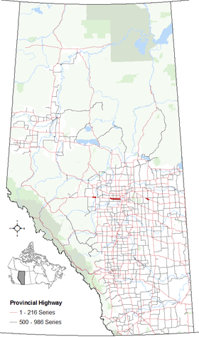
Alberta Highway 16A

Alberta Provincial Highway No. 16A[1] is the designation of three alternate routes off Alberta Highway 16 (the Yellowhead highway) in Alberta, Canada. The Evansburg – Entwistle section is called 16A:08 by Alberta Transportation, while 16A:24 runs through Vegreville. The section west of Edmonton is labelled 16A:14 and 16A:16 on Alberta Transportation maps, but is better known as Parkland Highway and Stony Plain Road.
Evansburg – Entwistle
| ||||
|---|---|---|---|---|
| Route information | ||||
| Maintained by Alberta Transportation | ||||
| Length: | 13.6 km (8.5 mi) | |||
| Major junctions | ||||
| West end: |
| |||
|
| ||||
| East end: |
| |||
| Location | ||||
| Specialized and rural municipalities: | Yellowhead County, Parkland County | |||
| Highway system | ||||
|
Provincial highways in Alberta
| ||||
Highway 16A:08 parallels Highway 16 to the north, intersecting Highway 22, and passing through Evansburg, the Pembina River Provincial Park, and Entwistle.
Major intersections
Starting from the west end of Highway 16A:[2]
| Municipality | km | Intersecting road | Notes | Coordinates | |
|---|---|---|---|---|---|
| Yellowhead County | 0.0 | 53°36′10″N 115°8′44″W / 53.60278°N 115.14556°W | |||
| 2.7 | 53°36′16″N 115°6′26″W / 53.60444°N 115.10722°W | ||||
| 8.5 | Urban Approach Road 115 Range Road 75 |
Evansburg | 53°36′7″N 115°1′20″W / 53.60194°N 115.02222°W | ||
| ↑ / ↓ | 10.8 | Pembina River | 53°35′59″N 115°0′15″W / 53.59972°N 115.00417°W | ||
| Parkland County | 11.3 | Road | Pembina River Provincial Park | 53°36′14″N 115°0′12″W / 53.60389°N 115.00333°W | |
| 13.0 | 50 Avenue, Main Street | Entwistle | 53°35′38″N 114°59′34″W / 53.59389°N 114.99278°W | ||
| 13.6 | Grade separated Hwy 16 Exit 289 |
53°35′22″N 114°59′19″W / 53.58944°N 114.98861°W | |||
| Continues as | |||||
| 1.000 mi = 1.609 km; 1.000 km = 0.621 mi | |||||
Parkland Highway
| ||||
|---|---|---|---|---|
| Parkland Highway | ||||
| Route information | ||||
| Maintained by Alberta Transportation | ||||
| Length: | 35 km (22 mi) | |||
| Major junctions | ||||
| West end: |
| |||
|
| ||||
| East end: |
| |||
| Location | ||||
| Specialized and rural municipalities: | Parkland County | |||
| Major cities: | Edmonton, Spruce Grove | |||
| Towns: | Stony Plain | |||
| Highway system | ||||
|
Provincial highways in Alberta
| ||||
Running for 35 km (22 mi) Parkland Highway (Highway 16A) runs parallel to Highway 16 to the south. The highway starts west of Stony Plain, Alberta near the hamlet of Carvel. Parkland Highway goes through the bedroom communities of Stony Plain, where it is a central thoroughfare, and Spruce Grove where it is the southern boundary. At Acheson it intersects with Highway 60. Highway 16A enters Edmonton along Stony Plain Road, splits into one-way streets where eastbound traffic follows 100 Avenue, before ending at Alberta Highway 216 (Anthony Henday Drive).
Major intersections
Vegreville
| ||||
|---|---|---|---|---|
| Route information | ||||
| Maintained by Alberta Transportation | ||||
| Length: | 11.2 km (7.0 mi) | |||
| Major junctions | ||||
| West end: |
| |||
| East end: |
| |||
| Location | ||||
| Specialized and rural municipalities: | County of Minburn No. 27 | |||
| Towns: | Vegreville | |||
| Highway system | ||||
|
Provincial highways in Alberta
| ||||
Highway 16A:24 runs through the Town of Vegreville as 50 Avenue.
Major intersections
Starting from the west end of Highway 16A:[2]
| Municipality | km | Intersecting road | Notes | Coordinates | |
|---|---|---|---|---|---|
| County of Minburn No. 27 | 0.0 | Grade separated Hwy 16 Exit 481 Eastbound exit, westbound entrance |
53°31′26″N 112°8′16″W / 53.52389°N 112.13778°W | ||
| Town of Vegreville | 6.1 | Hwy 857 concurrency begins | 53°30′0″N 112°3′58″W / 53.50000°N 112.06611°W | ||
| 8.1 | Hwy 857 concurrency ends | 53°29′25″N 112°2′31″W / 53.49028°N 112.04194°W | |||
| County of Minburn No. 27 | 11.2 | Grade separated Hwy 16 Exit 491 Westbound exit, eastbound entrance |
53°28′45″N 112°0′37″W / 53.47917°N 112.01028°W | ||
1.000 mi = 1.609 km; 1.000 km = 0.621 mi
| |||||
References
- ↑ Provincial Highways Designation Order, Alberta Transportation, p. 4
- 1 2 "2010 Provincial Highways 1 - 216 Series Progress Chart (map, 8 MB)" (PDF). Alberta Transportation. 2010. Retrieved 2011-01-25.
External links
- 2010 Provincial Highways 1 - 216 Series Progress Chart (map, 8 MB) by Alberta Transportation.

