Alberta Highway 63
| ||||
|---|---|---|---|---|
 | ||||
| Route information | ||||
| Length: | 433.7 km[1] (269.5 mi) | |||
| Major junctions | ||||
| South end: |
| |||
|
| ||||
| North end: | North of Fort MacKay | |||
| Location | ||||
| Specialized and rural municipalities: | Thorhild County, Athabasca County, Lac La Biche County, Wood Buffalo R.M. | |||
| Major cities: | Fort McMurray | |||
| Villages: | Boyle | |||
| Highway system | ||||
|
Provincial highways in Alberta
| ||||

Alberta Provincial Highway No. 63 is a major north–south highway in northern Alberta, Canada, connecting the booming communities of Fort McMurray and Fort MacKay to Edmonton via Highway 28. Well known for its many crashes and delays due to heavy equipment, twinning of the highway was expedited and completed in 2016 after a particularly high profile crash in 2012 claimed seven lives.
At its south terminus, Highway 63 begins at its intersection with Highway 28 approximately 6 km (4 mi) southwest of Radway, passing through Boyle and Fort McMurray before ending approximately 16 km (10 mi) north of its second crossing of the Athabasca River near Fort MacKay. Most of Highway 63 passes through boreal forest, although aspen parkland and farmland is predominant as far as Wandering River. The highway also passes through the Athabasca Oil Sands between Fort McMurray and Fort MacKay. From its southern terminus to Fort McMurray, the highway is designated as a core route of Canada's National Highway System.
History
Highway 63 has seen an increasingly high volume of traffic due to the growing oilsands industry in the Regional Municipality (RM) of Wood Buffalo, included in which is the oil centre of Fort McMurray, which has led to serious transportation-related problems. Trucks carrying large equipment can cause traffic delays, since they can be large enough to occupy two traffic lanes. Until 2016, most of the highway was a two-lane undivided roadway, with the exception of approximately 55 km (34 mi) from south of its intersection with Highway 881 through Fort McMurray to south of Fort MacKay. It is also the only road leading out of Fort McMurray, which makes it a critical link to the growing community.
After years of both public and political pressure, the provincial government announced in February 2006[2] that it would begin twinning the entire two-lane portion of the highway to a four-lane divided standard from Atmore to just south of Fort McMurray. The twinning began in 2006 and was estimated to take at least five years to complete.[3]
As of October 2009, the twinning of approximately 16 km (10 mi) of this 240 km (150 mi) corridor had been completed, with another 16 km (9.9 mi) expected to be graded by late 2011.[4] In October 2012, it was announced the remaining portion of Highway 63 between Grassland and Fort McMurray will be twinned by the end of 2016[5] and 36 km (22 mi) of twinned highway opened near Wandering River on November 5, 2012.[6] Interchanges within Fort McMurray at Confederation Way and Thickwood Boulevard were completed in late 2013.[7]
Between 2001 and 2005, over 1,000 crashes occurred on Highway 63 in which 25 people were killed and 257 others were injured.[8]
Major intersections
-

Highway 63 in Fort McMurray near Prairie Loop Blvd
-
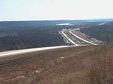
Highway 63 north of Fort McMurray
References
- ↑ "Provincial Highways 1 - 216 Progress Chart" (PDF). Alberta Transportation. March 2015. Retrieved 28 April 2016.
- ↑ "Government commits to twinning Highway 63". Government of Alberta. February 23, 2006. Archived from the original on March 25, 2016. Retrieved October 31, 2016.
- ↑ "Northeast Provincial Highway Projects". Government of Alberta. 2005. Archived from the original on July 11, 2006. Retrieved October 31, 2016.
- ↑ "Highway 63 twinning will resume after caribou calving season". Alberta Transportation. March 3, 2010. Archived from the original on March 25, 2016. Retrieved October 31, 2016.
- ↑ "Highway 63 twinning fast-tracked for fall 2016 completion". Government of Alberta. October 19, 2012. Retrieved October 19, 2012.
Highway 63 motorists will travel a safe, completely divided four-lane roadway between Grassland and Fort McMurray by the fall of 2016.
- ↑ "Newly-twinned Highway 63 section north of Wandering River opens today". Alberta Transportation. November 5, 2012. Archived from the original on March 25, 2016. Retrieved November 5, 2012.
- ↑ "Highway 63 twinning update - countdown to 2016". Alberta Transportation. April 19, 2013. Archived from the original on February 7, 2016. Retrieved October 17, 2013.
- ↑ "Multi-vehicle crash on Highway 63 kills 2". CBC News. March 29, 2008. Archived from the original on April 5, 2008. Retrieved January 1, 2011.
- ↑ Devos, P.Eng., Henry; Rebus, P.Eng., Bob; Furtado, P.Eng., Glen. "Alberta Infrastructure and Transportation" (PDF). Resolving Network Hierarchy with an Unconventional Core C/D Highway Concept, Highway 63, Fort McMurray. McElhanney Consulting Services Ltd. p. 13. Retrieved 4 May 2016.
- ↑ "Alberta opens new Fort McMurray bridge seven months early". Alberta Transportation. December 10, 2013. Archived from the original on June 3, 2016. Retrieved May 4, 2016.
External links
- Northeast Provincial Highway Projects by Alberta Transportation