Scissors Crossing, California
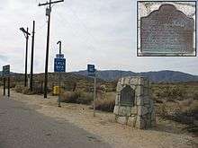
Scissors Crossing is a place name in San Diego County, California, in the United States.[1] It is a wrong-way concurrency junction where California State Highway 78 intersects with County Road S2, and is a notable point on the Pacific Crest Trail.[2][3] The unincorporated community of Shelter Valley lies 2 mi (3.2 km) to the south of Scissors Crossing along County Road S2.
S2 from Scissors Crossing southward closely follows the Southern Emigrant Trail or Great Southern Overland Route, until about 3 mi (4.8 km) beyond Agua Caliente Springs Road where Vallecito Creek turns away to the east. This was also the route of the San Antonio-San Diego Mail Line, Butterfield Overland Mail and later stage lines that ran from Southern California to Fort Yuma and on into what later became the states of Arizona and New Mexico. Nearby to the northwest of the crossing is the site of San Felipe Station, a division station for the desert section of the Butterfield Overland Mail to the east.
Coordinates: 33°5′48″N 116°28′31″W / 33.09667°N 116.47528°W
References
- ↑ U.S. Geological Survey Geographic Names Information System: Scissors Crossing, California
- ↑ Lindsay, Diana; Lindsay, Lowell (2010). Anza-Borrego Desert Region: A Guide to the State Park and Adjacent Areas of the Western Colorado Desert. Wilderness Press. p. 133. ISBN 978-0-89997-590-0.
Scissors Crossing (Junction of Hwys 78 and S-2)
- ↑ "Southern California - Pacific Crest Trail Association". Pacific Crest Trail Association. Archived from the original on 29 June 2014. Retrieved 30 December 2014.