Saukville, Wisconsin
| Saukville, Wisconsin | |
|---|---|
| Village | |
 Location of Saukville, Wisconsin | |
| Coordinates: 43°24′22″N 87°57′47″W / 43.40611°N 87.96306°WCoordinates: 43°24′22″N 87°57′47″W / 43.40611°N 87.96306°W | |
| Country | United States |
| State | Wisconsin |
| County | Ozaukee |
| Area[1] | |
| • Total | 3.85 sq mi (9.97 km2) |
| • Land | 3.80 sq mi (9.84 km2) |
| • Water | 0.05 sq mi (0.13 km2) |
| Elevation[2] | 889 ft (271 m) |
| Population (2010)[3] | |
| • Total | 4,451 |
| • Estimate (2012[4]) | 4,499 |
| • Density | 1,171.3/sq mi (452.2/km2) |
| Time zone | Central (CST) (UTC-6) |
| • Summer (DST) | CDT (UTC-5) |
| Area code(s) | 262 |
| FIPS code | 55-71725[5] |
| GNIS feature ID | 1584104[2] |
| Website |
village |
Saukville is a village in Ozaukee County, Wisconsin, United States. The population was 4,451 at the 2010 census. Most of the village perimeter is bordered by the Town of Saukville to the north and west, the Town of Port Washington to the east and southeast and by the Town of Grafton to the south and southwest.
Geography
Saukville is located at 43°22′52″N 87°56′40″W / 43.38111°N 87.94444°W (43.38137, −87.944578).[6]
According to the United States Census Bureau, the village has a total area of 3.85 square miles (9.97 km2), of which, 3.80 square miles (9.84 km2) of it is land and 0.05 square miles (0.13 km2) is water.[1]
History
Saukville was established on April 4, 1848 along the Milwaukee River. Previously, it was part of the old Port Washington area. Settlers began living in the area as early as 1845 and 1846. Before the white settlers came to the Saukville, the area was inhabited by the Native Americans, including the Sauk tribe.[7]
Some of the first settlers to Saukville were: Lott Blanchard, George C. Daniels, Joseph Fischbein, William Foster, Joseph Fowler, Stephen McIntosh, William Payne, Lemuel Sezer, Jonathan Tibetts and E. Wadsworth.[8]
Demographics
| Historical population | |||
|---|---|---|---|
| Census | Pop. | %± | |
| 1920 | 330 | — | |
| 1930 | 399 | 20.9% | |
| 1940 | 431 | 8.0% | |
| 1950 | 699 | 62.2% | |
| 1960 | 1,038 | 48.5% | |
| 1970 | 1,389 | 33.8% | |
| 1980 | 3,494 | 151.5% | |
| 1990 | 3,695 | 5.8% | |
| 2000 | 4,068 | 10.1% | |
| 2010 | 4,451 | 9.4% | |
| Est. 2015 | 4,463 | [9] | 0.3% |
2010 census
As of the census[3] of 2010, there were 4,451 people, 1,766 households, and 1,208 families residing in the village. The population density was 1,171.3 inhabitants per square mile (452.2/km2). There were 1,848 housing units at an average density of 486.3 per square mile (187.8/km2). The racial makeup of the village was 96.0% White, 0.7% African American, 0.4% Native American, 0.7% Asian, 0.6% from other races, and 1.6% from two or more races. Hispanic or Latino of any race were 2.9% of the population.
There were 1,766 households of which 36.2% had children under the age of 18 living with them, 53.6% were married couples living together, 10.4% had a female householder with no husband present, 4.4% had a male householder with no wife present, and 31.6% were non-families. 26.2% of all households were made up of individuals and 5.7% had someone living alone who was 65 years of age or older. The average household size was 2.52 and the average family size was 3.06.
The median age in the village was 36.7 years. 26.2% of residents were under the age of 18; 7.6% were between the ages of 18 and 24; 29.4% were from 25 to 44; 28.1% were from 45 to 64; and 8.7% were 65 years of age or older. The gender makeup of the village was 50.2% male and 49.8% female.
2000 census
As of the census[5] of 2000, there were 4,068 people, 1,583 households, and 1,104 families residing in the village. The population density was 1,366.3 people per square mile (527.1/km²). There were 1,639 housing units at an average density of 550.5 per square mile (212.4/km²). The racial makeup of the village was 97.42% White, 0.57% Black or African American, 0.15% Native American, 0.61% Asian, 0.32% from other races, and 0.93% from two or more races. 2.19% of the population were Hispanic or Latino of any race.
There were 1,583 households out of which 38.0% had children under the age of 18 living with them, 55.2% were married couples living together, 10.4% had a female householder with no husband present, and 30.2% were non-families. 24.1% of all households were made up of individuals and 5.6% had someone living alone who was 65 years of age or older. The average household size was 2.56 and the average family size was 3.07.
In the village the population was spread out with 27.5% under the age of 18, 9.5% from 18 to 24, 34.8% from 25 to 44, 21.0% from 45 to 64, and 7.2% who were 65 years of age or older. The median age was 33 years. For every 100 females there were 103.6 males. For every 100 females age 18 and over, there were 100.5 males.
The median income for a household in the village was $53,159, and the median income for a family was $62,436. Males had a median income of $41,625 versus $28,583 for females. The per capita income for the village was $22,035. About 1.4% of families and 3.1% of the population were below the poverty line, including 3.4% of those under age 18 and 9.5% of those age 65 or over.
Notable people
- Robert Brooks, Wisconsin State Assemblyman and businessman
- Tom Uttech, artist
References
- 1 2 "US Gazetteer files 2010". United States Census Bureau. Retrieved 2012-11-18.
- 1 2 "US Board on Geographic Names". United States Geological Survey. 2007-10-25. Retrieved 2008-01-31.
- 1 2 "American FactFinder". United States Census Bureau. Retrieved 2012-11-18.
- ↑ "Population Estimates". United States Census Bureau. Retrieved 2013-06-24.
- 1 2 "American FactFinder". United States Census Bureau. Retrieved 2008-01-31.
- ↑ "US Gazetteer files: 2010, 2000, and 1990". United States Census Bureau. 2011-02-12. Retrieved 2011-04-23.
- ↑ "Newland Became Cedarburg". The Milwaukee Sentinel. 4 September 1967. pp. Part 5, Page 5. Retrieved 23 April 2015.
- ↑ Village of Saukville - General Information - history
- ↑ "Annual Estimates of the Resident Population for Incorporated Places: April 1, 2010 to July 1, 2015". Retrieved July 2, 2016.
- ↑ "Census of Population and Housing". Census.gov. Retrieved June 4, 2015.
External links
| Central city | 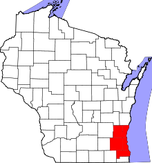 | |
|---|---|---|
| Largest municipalities (over 25,000 in 2010) | ||
| Municipalities (over 10,000 in 2010) | ||
| Smaller municipalities (under 10,000 in 2010) | ||
| Counties | ||
Municipalities and communities of Ozaukee County, Wisconsin, United States | ||
|---|---|---|
| Cities |  | |
| Villages | ||
| Towns | ||
| CDP | ||
| Unincorporated communities | ||
| Footnotes | ‡This populated place also has portions in an adjacent county or counties | |