Hartland, Wisconsin
| Hartland, Wisconsin | |
|---|---|
| Village | |
 Location in Waukesha County and the state of Wisconsin. | |
| Coordinates: 43°6′1″N 88°20′40″W / 43.10028°N 88.34444°WCoordinates: 43°6′1″N 88°20′40″W / 43.10028°N 88.34444°W | |
| Country | United States |
| State | Wisconsin |
| County | Waukesha |
| Area[1] | |
| • Total | 5.17 sq mi (13.39 km2) |
| • Land | 5.12 sq mi (13.26 km2) |
| • Water | 0.05 sq mi (0.13 km2) |
| Elevation[2] | 935 ft (285 m) |
| Population (2010)[3] | |
| • Total | 9,110 |
| • Estimate (2012[4]) | 9,183 |
| • Density | 1,779.3/sq mi (687.0/km2) |
| Time zone | Central (CST) (UTC-6) |
| • Summer (DST) | CDT (UTC-5) |
| Area code(s) | 262 |
| FIPS code | 55-33100[5] |
| GNIS feature ID | 1566105[2] |
Hartland is a village in Waukesha County, Wisconsin, along the Bark River, and is a suburb of Milwaukee. The population was 9,110 at the 2010 census.
Geography
Hartland is located at 43°6′1″N 88°20′40″W / 43.10028°N 88.34444°W (43.100180, −88.344452).[6] It is in the Lake Country area of Waukesha County.
According to the United States Census Bureau, the village has a total area of 5.17 square miles (13.39 km2), of which, 5.12 square miles (13.26 km2) of it is land and 0.05 square miles (0.13 km2) is water.[1]
Demographics
| Historical population | |||
|---|---|---|---|
| Census | Pop. | %± | |
| 1880 | 287 | — | |
| 1890 | 486 | 69.3% | |
| 1900 | 629 | 29.4% | |
| 1910 | 728 | 15.7% | |
| 1920 | 800 | 9.9% | |
| 1930 | 945 | 18.1% | |
| 1940 | 998 | 5.6% | |
| 1950 | 1,190 | 19.2% | |
| 1960 | 2,068 | 73.8% | |
| 1970 | 2,763 | 33.6% | |
| 1980 | 5,559 | 101.2% | |
| 1990 | 6,906 | 24.2% | |
| 2000 | 7,905 | 14.5% | |
| 2010 | 9,110 | 15.2% | |
| Est. 2015 | 9,219 | [7] | 1.2% |
2010 census
As of the census[3] of 2010, there were 9,110 people, 3,566 households, and 2,440 families residing in the village. The population density was 1,779.3 inhabitants per square mile (687.0/km2). There were 3,746 housing units at an average density of 731.6 per square mile (282.5/km2). The racial makeup of the village was 95.1% White, 0.8% African American, 0.3% Native American, 1.7% Asian, 0.1% Pacific Islander, 0.5% from other races, and 1.4% from two or more races. Hispanic or Latino of any race were 2.9% of the population.
There were 3,566 households of which 37.3% had children under the age of 18 living with them, 54.4% were married couples living together, 10.2% had a female householder with no husband present, 3.8% had a male householder with no wife present, and 31.6% were non-families. 26.4% of all households were made up of individuals and 10.2% had someone living alone who was 65 years of age or older. The average household size was 2.55 and the average family size was 3.12.
The median age in the village was 37.5 years. 28% of residents were under the age of 18; 7.3% were between the ages of 18 and 24; 26.4% were from 25 to 44; 28.2% were from 45 to 64; and 10% were 65 years of age or older. The gender makeup of the village was 47.4% male and 52.6% female.
2000 census
As of the census[5] of 2000, there were 7,905 people, 3,002 households, and 2,161 families residing in the village. The population density was 1,753.7 people per square mile (676.7/km²). There were 3,140 housing units at an average density of 696.6 per square mile (268.8/km²). The racial makeup of the village was 97.70% White, 0.28% African American, 0.33% Native American, 0.48% Asian, 0.43% from other races, and 0.78% from two or more races. Hispanic or Latino of any race were 1.51% of the population.
There were 3,002 households out of which 41.3% had children under the age of 18 living with them, 57.4% were married couples living together, 11.0% had a female householder with no husband present, and 28.0% were non-families. 22.3% of all households were made up of individuals and 7.2% had someone living alone who was 65 years of age or older. The average household size was 2.63 and the average family size was 3.13.
In the village the population was spread out with 29.7% under the age of 18, 7.8% from 18 to 24, 33.5% from 25 to 44, 21.5% from 45 to 64, and 7.5% who were 65 years of age or older. The median age was 34 years. For every 100 females there were 93.7 males. For every 100 females age 18 and over, there were 92.7 males.
The median income for a household in the village was $58,359, and the median income for a family was $67,844. Males had a median income of $48,475 versus $30,253 for females. The per capita income for the village was $26,537. About 1.8% of families and 2.6% of the population were below the poverty line, including 2.2% of those under age 18 and 3.9% of those age 65 or over.
Economy
Education
Hartland is served by the Arrowhead Union High School District[10] along with three of its five feeder school districts: Hartland-Lakeside School District, Lake Country School District,[11] and Swallow School District.[12] The district's only secondary school is Arrowhead High School. The Arrowhead District has nine feeder schools: North Shore Middle, Swallow, Merton, Lake Country, Stone Bank, Richmond, and North Lake. North Shore Middle School has two feeder schools: Hartland South Elementary, and Hartland North Elementary.
Lake Country Lutheran High School and University Lake School are private schools in Hartland.[13] Divine Redeemer Lutheran School and Zion Lutheran School[14] are K-8 private schools.[15]
Hartland Public Library,[16] located in the downtown village of Hartland is used by some students.
Religion
- Divine Redeemer Lutheran Church & School, a Lutheran Church–Missouri Synod congregation
- First Congregational Church, on the National Register of Historic Places
- Lake Country Congregational Church, built in 1910 as a Dansk Evangelical Lutheran Kirke
- Lake Country Unitarian Universalist Church
- Oakwood Church
- St. Charles Catholic Church, the only Catholic Church in the village of Hartland
- Westbrook Church
- Zion Evangelical Lutheran Church, a WELS congregation, listed on the National Register of Historic Places
Recreation
- Camp Whitcomb/Mason, a Boys and Girls Clubs summer camp, is located near Hartland.
Notable people
- Ben Askren, wrestler and MMA fighter
- Charles Carpenter, football player
- Judson Hall, Wisconsin State Assembly
- Nick Hayden, Defensive Tackle, Dallas Cowboys
- Karen McQuestion, author
- David Merkow, golfer
- Joe Panos, former NFL player
References
- 1 2 "US Gazetteer files 2010". United States Census Bureau. Retrieved November 18, 2012.
- 1 2 "US Board on Geographic Names". United States Geological Survey. 2007-10-25. Retrieved 2008-01-31.
- 1 2 "American FactFinder". United States Census Bureau. Retrieved November 18, 2012.
- ↑ "Population Estimates". United States Census Bureau. Retrieved June 24, 2013.
- 1 2 "American FactFinder". United States Census Bureau. Retrieved 2008-01-31.
- ↑ "US Gazetteer files: 2010, 2000, and 1990". United States Census Bureau. 2011-02-12. Retrieved 2011-04-23.
- ↑ "Annual Estimates of the Resident Population for Incorporated Places: April 1, 2010 to July 1, 2015". Retrieved July 2, 2016.
- ↑ "Census of Population and Housing". Census.gov. Retrieved June 4, 2015.
- ↑ Wisconsin Policy Research Institute
- ↑ http://www.arrowheadschools.org/display/router.asp?DocID=72 arrowheadschools.org
- ↑ http://www.lcs.k12.wi.us/ lcs.k12.wi.us
- ↑ http://www.swallowschool.org/
- ↑ http://www.lakecountryhs.org/SchoolInfo/tabid/131/Default.aspx
- ↑ http://www.zionhartland.org
- ↑ http://www.drlc.org/school_facts.html
- ↑ http://www.hartlandlibrary.org
External links
- Hartland, Wisconsin village website
- Hartland Area Chamber of Commerce
- Sanborn fire insurance maps: 1894 1899 1905 1914 1922
Municipalities and communities of Waukesha County, Wisconsin, United States | ||
|---|---|---|
| Cities | 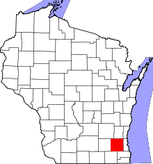 | |
| Villages | ||
| Towns | ||
| CDP | ||
| Unincorporated communities | ||
| Ghost towns | ||
| Footnotes | ‡This populated place also has portions in an adjacent county or counties | |
| Central city |  | |
|---|---|---|
| Largest municipalities (over 25,000 in 2010) | ||
| Municipalities (over 10,000 in 2010) | ||
| Smaller municipalities (under 10,000 in 2010) | ||
| Counties | ||