Little Kohler, Wisconsin
| Little Kohler, Wisconsin | |
|---|---|
| Unincorporated community | |
 Little Kohler, Wisconsin  Little Kohler, Wisconsin | |
| Coordinates: 43°29′47″N 88°01′24″W / 43.49639°N 88.02333°WCoordinates: 43°29′47″N 88°01′24″W / 43.49639°N 88.02333°W | |
| Country | United States |
| State | Wisconsin |
| County | Ozaukee |
| Elevation | 866 ft (264 m) |
| Time zone | Central (CST) (UTC-6) |
| • Summer (DST) | CDT (UTC-5) |
| Area code(s) | 262 |
| GNIS feature ID | 1567600[1] |
Little Kohler, or Kohler, is an unincorporated community located in the Town of Fredonia in Ozaukee County, Wisconsin, United States.[2][3]
Transportation
Little Kohler is located at the intersection of County Highway H (Kohler Drive, Fredonia-Kohler Road), Belgium-Kohler Road, and County Highway E. County H had been designated as Wisconsin Highway 84 before the highway was decommissioned.[4]
History
Martin and Theresa Koller and their children settled in the area in the 1840s, having emigrated from Bavaria. The community was originally named Koller, after them.[5] In 1912, the Kohler Company created a planned community in an area of Sheboygan County formerly known as River Side. They named the village Kohler after the family company. At some point, the community of Koller began to be called Kohler as well. Residents of the Kohler in Ozaukee County then began referring to their community as "Little Kohler" to differentiate the two.[6]
Little Kohler was home to Camp Fredonia, an Allied prisoner of war camp that held 330 German prisoners of war. The camp opened on June 15, 1945, and closed in January 1946.[7]
Attractions
The Pineview Wildlife Rehabilitation Center is located in Little Kohler.[8] St. Mary Mother of Sorrows Catholic Church was built in Little Kohler in 1849. This parish merged with those in Fredonia and Holy Cross in 2001.[9][10][11]
References
- ↑ "US Board on Geographic Names". United States Geological Survey. 2007-10-25. Retrieved 2008-01-31.
- ↑ "Term: Kohler, Ozaukee Co.". Dictionary of Wisconsin History. Archived from the original on February 2, 2014.
- ↑ http://dhs.wi.gov/VitalRecords/pdf/cvtlist.pdf
- ↑ "1973 Official Highway Map of Wisconsin". Wisconsin Department of Transportation. 1973.
- ↑ Kevin Struck, "The story of the 'other' Kohler, 20 miles to the southwest." The Kohler Villager, vol. 4 no. 12, (August 2009) http://sheboyco.com/blog/wp-content/uploads/2009/08/August09.pdf
- ↑ "Newland Became Cedarburg". The Milwaukee Sentinel. 4 September 1967. pp. Part 5, Page 5. Retrieved 23 April 2015.
- ↑ Cowley, Betty (2002-01-01). Stalag Wisconsin: Inside WW II Prisoner-of-war Camps. Badger Books Inc. pp. 120–25. ISBN 9781878569837.
- ↑ "Pine View Wildlife Rehabilitation Center".
- ↑ http://www.holyrosaryonline.com/Parish/tabid/324/Default.aspx
- ↑ "Fcgw.org". www.fcgw.org. Retrieved 2016-04-10.
- ↑ http://www.archmil.org/news/ShowArchivedNews.asp?ID=635
Municipalities and communities of Ozaukee County, Wisconsin, United States | ||
|---|---|---|
| Cities | 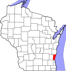 | |
| Villages | ||
| Towns | ||
| CDP | ||
| Unincorporated communities | ||
| Footnotes | ‡This populated place also has portions in an adjacent county or counties | |