Greendale, Wisconsin
| Greendale, Wisconsin | |
|---|---|
| Village | |
|
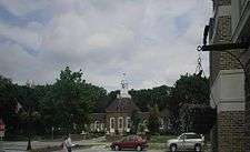
Greendale Village Hall | |
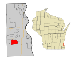 Location of Greendale, Wisconsin | |
| Coordinates: 42°56′15″N 87°59′49″W / 42.93750°N 87.99694°WCoordinates: 42°56′15″N 87°59′49″W / 42.93750°N 87.99694°W | |
| Country | United States |
| State | Wisconsin |
| County | Milwaukee |
| Area[1] | |
| • Total | 5.57 sq mi (14.43 km2) |
| • Land | 5.56 sq mi (14.40 km2) |
| • Water | 0.01 sq mi (0.03 km2) |
| Elevation[2] | 738 ft (225 m) |
| Population (2010)[3] | |
| • Total | 14,046 |
| • Estimate (2012[4]) | 14,325 |
| • Density | 2,526.3/sq mi (975.4/km2) |
| Time zone | Central (CST) (UTC-6) |
| • Summer (DST) | CDT (UTC-5) |
| Area code(s) | 414 |
| FIPS code | 55-31125[5] |
| GNIS feature ID | 1565837[2] |
| Website |
www |
Greendale is a village in Milwaukee County, Wisconsin, United States. The population was 14,046 at the 2010 census. Greendale is located southwest of Milwaukee, Wisconsin, and is a part of the Milwaukee metropolitan area.
History
Greendale was one of three "Greenbelt" communities constructed by the U.S. Department of Agriculture, starting in 1936, as a part of President Franklin Roosevelt's New Deal. The communities were built to demonstrate a new kind of suburban living, with housing situated within easy walking distance of gardens, employment and the town center. The other Greenbelt communities were Greenbelt, Maryland and Greenhills, Ohio.[6] The communities were designed with three goals in mind: to combine the advantages of city and country life; to provide good housing at reasonable prices for moderate income families; and to provide jobs to unemployed workers.
All of the property was owned by the government and rented to families based on income, housing need and family size. Some exceptions were made for those with special skills, such as medical doctors and other professionals. In 1949 the Public Housing Administration gave Greendale residents the right to purchase their homes from the government. The transfer of ownership from the government to the people was largely complete by 1952.[7]
In 1996, the shopping district in the center of the village was purchased by the Grandhaven investment firm founded by Roy Reiman, founder of a publishing company headquartered in the village. The remake of the "Village Center" brought updates, attracted new restaurants, and made the village center more of a tourist attraction.[8]
Geography
Greendale is located at 42°56′15″N 87°59′49″W / 42.937615°N 87.996884°W (42.937615, -87.996884).[9] The Root River flows through the western part of the village.
According to the United States Census Bureau, the village has a total area of 5.57 square miles (14.43 km2), of which, 5.56 square miles (14.40 km2) of it is land and 0.01 square miles (0.03 km2) is water.[1]
Demographics
| Historical population | |||
|---|---|---|---|
| Census | Pop. | %± | |
| 1940 | 2,527 | — | |
| 1950 | 2,752 | 8.9% | |
| 1960 | 6,845 | 148.7% | |
| 1970 | 15,089 | 120.4% | |
| 1980 | 16,928 | 12.2% | |
| 1990 | 15,128 | −10.6% | |
| 2000 | 14,405 | −4.8% | |
| 2010 | 14,046 | −2.5% | |
| Est. 2015 | 14,333 | [10] | 2.0% |
2010 census
As of the census[3] of 2010, there were 14,046 people, 6,075 households, and 4,016 families residing in the village. The population density was 2,526.3 inhabitants per square mile (975.4/km2). There were 6,294 housing units at an average density of 1,132.0 per square mile (437.1/km2). The racial makeup of the village was 92.8% White, 1.2% African American, 0.4% Native American, 3.1% Asian, 0.9% from other races, and 1.6% from two or more races. Hispanic or Latino of any race were 4.7% of the population.
There were 6,075 households of which 28.0% had children under the age of 18 living with them, 52.5% were married couples living together, 10.0% had a female householder with no husband present, 3.6% had a male householder with no wife present, and 33.9% were non-families. 30.1% of all households were made up of individuals and 17% had someone living alone who was 65 years of age or older. The average household size was 2.31 and the average family size was 2.87.
The median age in the village was 45.3 years. 22.1% of residents were under the age of 18; 5.6% were between the ages of 18 and 24; 21.7% were from 25 to 44; 28.2% were from 45 to 64; and 22.2% were 65 years of age or older. The gender makeup of the village was 46.6% male and 53.4% female.
Historic places
The Greendale Historic District was added to the National Register of Historic Places in 2005 and designated a National Historic Landmark in 2012. Trimborn Farm, also on the National Register of Historic Places, is in Greendale.
Education
The village has one public high school and three public elementary schools.[12] Greendale High School was named by Newsweek as one of America’s Best High Schools in its 2009 & 2010 rankings.[13][14] In 2007 the Greendale School District was ranked by Milwaukee Magazine as the top school system among the Milwaukee metropolitan area.[15] Martin Luther High School is a private high school in the village.
Recreation
Part of the Root River Parkway is in Greendale.[16] Whitnall Park, which is the largest park in Milwaukee County.[17] borders Greendale on the western boundary of the village. Whitnall Park offers many recreation options, including an 18-hole golf course,[18] many hiking, biking and cross-country ski trails,[19] the Wehr Nature Center [20] and the Boerner Botanical Gardens.[21]
Commerce
The largest mall in Wisconsin,[22] Southridge Mall, is located in Greendale. The mall has over 125 stores, including the major department stores Boston Store, jcpenney, Kohl's, Sears and Macy's.[23] The nearby downtown village center has more than a dozen independent shops [24] and six restaurants that cater to tourists and locals alike.[25]
Notable people
- Nineteenth-century folklorist and linguist Jeremiah Curtin lived in what is now Greendale. His boyhood home stands as a historic landmark.
- Emmy-nominated actress Jane Kaczmarek was born and raised in Greendale. She attended Greendale High School and still plays a major role in its theater department.
- Roy Reiman, founder of Reiman Publications, which is now owned by The Reader's Digest Association
- All-AFL player Dave Smith attended Greendale High School.
- Greendale High School graduate Sarah Pfisterer starred in the Broadway productions Phantom of the Opera and Show Boat between 1988 and 1997.[26]
Gallery
-
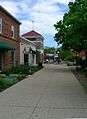
Downtown Shopping District in Greendale
-
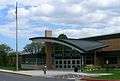
Main Entrance to Greendale High School
-
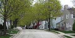
A street view in the National Historic District
-
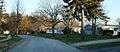
Street view in the National Historic District
-
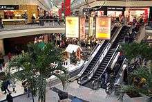
Southridge Mall
-
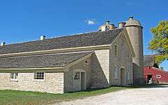
Trimborn Farm
-
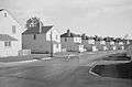
Houses in Greendale (historical photo)
-
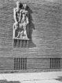
Original stone carving by Alonzo Hauser
-
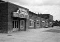
The now gone Greendale Theater
References
- 1 2 "US Gazetteer files 2010". United States Census Bureau. Retrieved 2012-11-18.
- 1 2 "US Board on Geographic Names". United States Geological Survey. 2007-10-25. Retrieved 2008-01-31.
- 1 2 "American FactFinder". United States Census Bureau. Retrieved 2012-11-18.
- ↑ "Population Estimates". United States Census Bureau. Retrieved 2013-06-24.
- ↑ "American FactFinder". United States Census Bureau. Retrieved 2008-01-31.
- ↑ Lindsay Isaacs. "A federal experiment sets out lasting models for suburban development". American City & County.
- ↑ http://www.wisconsinhistory.org/Content.aspx?dsNav=N:4294963828-4294963805&dsRecordDetails=R:CS370
- ↑ Kenneth R. Lamke. "Pioneering Residences At Heart Of Suburb's Modern Market". Chicago Tribune, June 14, 1998.
- ↑ "US Gazetteer files: 2010, 2000, and 1990". United States Census Bureau. 2011-02-12. Retrieved 2011-04-23.
- ↑ "Annual Estimates of the Resident Population for Incorporated Places: April 1, 2010 to July 1, 2015". Retrieved July 2, 2016.
- ↑ "Census of Population and Housing". Census.gov. Retrieved June 4, 2015.
- ↑ http://www.greendale.k12.wi.us/about-us.html
- ↑ http://www.newsweek.com/id/201160 Retrieved 2009-10-29
- ↑ http://www.newsweek.com/feature/2010/americas-best-high-schools/list.html
- ↑ http://www.milwaukeemagazine.com/guides/default.asp?newmessageid=13643 Retrieved 2009-10-29
- ↑ http://county.milwaukee.gov/ImageLibrary/Groups/cntyParks/maps/Root_River_Parkway_Sout1.pdf
- ↑ http://www.wisconsinbirds.org/trail/sites/whitnallpark.htm
- ↑ http://milwaukeecountygolfcourses.com/whitnall_details/
- ↑ http://www.trailville.com/wiki/WI_Milwaukee_Whitnall_Park
- ↑ http://county.milwaukee.gov/WehrNatureCenter10115.htm
- ↑ http://county.milwaukee.gov/BoernerBotanicalGard10113.htm
- ↑ "Southridge Mall largest Milwaukee-area shopping center". Milwaukee Business Journal, January 31, 2014. Accessed April 28, 2016.(subscription required)
- ↑ http://www.simon.com/mall/southridge-mall/about
- ↑ http://discovergreendale.com/shops/
- ↑ http://discovergreendale.com/restaurants/
- ↑ http://www.ibdb.com/Person/View/82743
External links
Municipalities and communities of Milwaukee County, Wisconsin, United States | ||
|---|---|---|
| Cities | 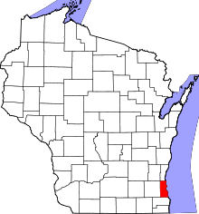 | |
| Villages | ||
| Ghost towns/ neighborhoods | ||
| Indian reservation | ||
| Footnotes | ‡This populated place also has portions in another county or counties | |
| Central city |  | |
|---|---|---|
| Largest municipalities (over 25,000 in 2010) | ||
| Municipalities (over 10,000 in 2010) | ||
| Smaller municipalities (under 10,000 in 2010) | ||
| Counties | ||