Holy Cross, Wisconsin
| Holy Cross, Wisconsin | |
|---|---|
| Unincorporated community | |
 Holy Cross, Wisconsin  Holy Cross, Wisconsin | |
| Coordinates: 43°28′13″N 87°53′44″W / 43.47028°N 87.89556°WCoordinates: 43°28′13″N 87°53′44″W / 43.47028°N 87.89556°W | |
| Country | United States |
| State | Wisconsin |
| County | Ozaukee |
| Elevation | 774 ft (236 m) |
| Time zone | Central (CST) (UTC-6) |
| • Summer (DST) | CDT (UTC-5) |
| Area code(s) | 262 |
| GNIS feature ID | 1566584[1] |
Holy Cross is an unincorporated community located in the town of Belgium in Ozaukee County, Wisconsin, United States.[2][3] Holy Cross is located just east Fredonia and southwest of Belgium.
Holy Cross, like nearby Dacada, was settled by immigrants from Luxembourg in the 1840s and 1850s. The name for the community comes from the former Catholic parish of Holy Cross, which was formed in the area in 1845.[4][5]
References
- ↑ "US Board on Geographic Names". United States Geological Survey. 2007-10-25. Retrieved 2008-01-31.
- ↑ http://www.wisconsinhistory.org/dictionary/index.asp?action=view&term_id=5284
- ↑ http://dhs.wi.gov/VitalRecords/pdf/cvtlist.pdf
- ↑ T.J. Sullivan, The Catholic Church in Wisconsin. Catholic Historical Publishing Company, 1896. http://www.rootsweb.ancestry.com/~wiozauke/churches/HolyCross.html
- ↑ Collections of the State Historical Society of Wisconsin, vol. 14. p. 377, 379. https://books.google.com/books?id=FEEUAAAAYAAJ&pg=PA377&dq="holy+cross"
Municipalities and communities of Ozaukee County, Wisconsin, United States | ||
|---|---|---|
| Cities | 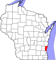 | |
| Villages | ||
| Towns | ||
| CDP | ||
| Unincorporated communities | ||
| Footnotes | ‡This populated place also has portions in an adjacent county or counties | |
This article is issued from Wikipedia - version of the 10/18/2016. The text is available under the Creative Commons Attribution/Share Alike but additional terms may apply for the media files.