Bayside, Wisconsin
| Bayside, Wisconsin | |
|---|---|
| Village | |
 Location of Bayside, Wisconsin | |
| Coordinates: 43°10′49″N 87°54′17″W / 43.18028°N 87.90472°WCoordinates: 43°10′49″N 87°54′17″W / 43.18028°N 87.90472°W | |
| Country | United States |
| State | Wisconsin |
| Counties | Milwaukee, Ozaukee |
| Area[1] | |
| • Total | 2.39 sq mi (6.19 km2) |
| • Land | 2.39 sq mi (6.19 km2) |
| • Water | 0 sq mi (0 km2) |
| Elevation[2] | 673 ft (205 m) |
| Population (2010)[3] | |
| • Total | 4,389 |
| • Estimate (2012[4]) | 4,411 |
| • Density | 1,836.4/sq mi (709.0/km2) |
| Time zone | Central (CST) (UTC-6) |
| • Summer (DST) | CDT (UTC-5) |
| ZIP code | 53217 |
| Area code(s) | 414 |
| FIPS code | 55-05450[5] |
| GNIS feature ID | 1561327[2] |
| Website |
village |
Bayside is a village in Milwaukee and Ozaukee counties in the U.S. state of Wisconsin. The population was 4,389 at the 2010 census. Of this, 4,300 were in Milwaukee County, and only 89 were in Ozaukee County.
Geography
Bayside is located at 43°10′49″N 87°54′17″W / 43.18028°N 87.90472°W (43.180275, -87.904735).[6]
According to the United States Census Bureau, the village has a total area of 2.39 square miles (6.19 km2), all of it land.[1] Lake Michigan borders the eastern edge of Bayside. Most of the village is in Milwaukee County, but a small portion at the end of Lake Drive is in Ozaukee County.
Education
Two public primary school districts serve Bayside. The Fox Point-Bayside School District serves the eastern part of the village, where students attend Stormonth Elementary and Bayside Middle Schools. The western part of the village is served by the Maple Dale-Indian Hill School District, where students attend Indian Hill Elementary and Maple Dale Middle Schools. Nicolet High School in Glendale serves all students residing in Bayside.
Government
The village of Bayside is served by its own police department but contracts out its fire fighting and EMS services to the North Shore Fire Department.
Demographics
| Historical population | |||
|---|---|---|---|
| Census | Pop. | %± | |
| 1960 | 3,181 | — | |
| 1970 | 4,461 | 40.2% | |
| 1980 | 4,724 | 5.9% | |
| 1990 | 4,789 | 1.4% | |
| 2000 | 4,518 | −5.7% | |
| 2010 | 4,389 | −2.9% | |
| Est. 2015 | 4,419 | [7] | 0.7% |
2010 census
As of the census[3] of 2010, there were 4,389 people, 1,831 households, and 1,281 families residing in the village. The population density was 1,836.4 inhabitants per square mile (709.0/km2). There were 1,945 housing units at an average density of 813.8 per square mile (314.2/km2). The racial makeup of the village was 90.7% White, 3.3% African American, 0.3% Native American, 3.7% Asian, 0.1% Pacific Islander, 0.5% from other races, and 1.4% from two or more races. Hispanic or Latino of any race were 2.8% of the population.
There were 1,831 households of which 29.9% had children under the age of 18 living with them, 62.4% were married couples living together, 6.1% had a female householder with no husband present, 1.5% had a male householder with no wife present, and 30.0% were non-families. 26.3% of all households were made up of individuals and 14.7% had someone living alone who was 65 years of age or older. The average household size was 2.38 and the average family size was 2.89.
The median age in the village was 48 years. 23.5% of residents were under the age of 18; 3.6% were between the ages of 18 and 24; 18.5% were from 25 to 44; 33.6% were from 45 to 64; and 20.8% were 65 years of age or older. The gender makeup of the village was 46.9% male and 53.1% female.
2000 census
As of the census[5] of 2000, there were 4,518 people, 1,769 households, and 1,326 families residing in the village. The population density was 1,898.7 people per square mile (732.9/km²). There were 1,834 housing units at an average density of 770.8 per square mile (297.5/km²). The racial makeup of the village was 94.36% White, 2.77% African American, 0.15% Native American, 1.81% Asian, 0.09% Pacific Islander, 0.31% from other races, and 0.51% from two or more races. Hispanic or Latino of any race were 1.70% of the population.
There were 1,769 households out of which 31.5% had children under the age of 18 living with them, 67.3% were married couples living together, 5.4% had a female householder with no husband present, and 25.0% were non-families. 22.8% of all households were made up of individuals and 10.5% had someone living alone who was 65 years of age or older. The average household size was 2.46 and the average family size was 2.89.
In the village the population was spread out with 23.2% under the age of 18, 3.9% from 18 to 24, 20.0% from 25 to 44, 32.2% from 45 to 64, and 20.6% who were 65 years of age or older. The median age was 46 years. For every 100 females there were 91.3 males. For every 100 females age 18 and over, there were 88.4 males.
The median income for a household in the village was $88,982, and the median income for a family was $104,771. Males had a median income of $74,722 versus $41,935 for females. The per capita income for the village was $49,357. About 3.0% of families and 2.9% of the population were below the poverty line, including 3.9% of those under age 18 and 0.7% of those age 65 or over.
Notable people
- Gaston Vandermeerssche, leader in Dutch resistance, World War II
- Mark Metcalf, actor who played ROTC instructor Doug Neidermeyer.[9]
References
- 1 2 "US Gazetteer files 2010". United States Census Bureau. Archived from the original on 2012-01-24. Retrieved 2012-11-18.
- 1 2 "US Board on Geographic Names". United States Geological Survey. 2007-10-25. Retrieved 2008-01-31.
- 1 2 "American FactFinder". United States Census Bureau. Retrieved 2012-11-18.
- ↑ "Population Estimates". United States Census Bureau. Archived from the original on 2013-06-17. Retrieved 2013-06-24.
- 1 2 "American FactFinder". United States Census Bureau. Archived from the original on 2013-09-11. Retrieved 2008-01-31.
- ↑ "US Gazetteer files: 2010, 2000, and 1990". United States Census Bureau. 2011-02-12. Retrieved 2011-04-23.
- ↑ "Annual Estimates of the Resident Population for Incorporated Places: April 1, 2010 to July 1, 2015". Retrieved July 2, 2016.
- ↑ "Census of Population and Housing". Census.gov. Archived from the original on May 11, 2015. Retrieved June 4, 2015.
- ↑ Olson, Drew and Andy Tarnoff (February 22, 2008). Milwaukee Talks: Actor / restaurateur Mark Metcalf. OnMilwaukee.com
External links
Municipalities and communities of Milwaukee County, Wisconsin, United States | ||
|---|---|---|
| Cities | 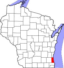 | |
| Villages | ||
| Ghost towns/ neighborhoods | ||
| Indian reservation | ||
| Footnotes | ‡This populated place also has portions in another county or counties | |
Municipalities and communities of Ozaukee County, Wisconsin, United States | ||
|---|---|---|
| Cities | 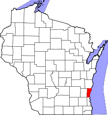 | |
| Villages | ||
| Towns | ||
| CDP | ||
| Unincorporated communities | ||
| Footnotes | ‡This populated place also has portions in an adjacent county or counties | |
| Central city | 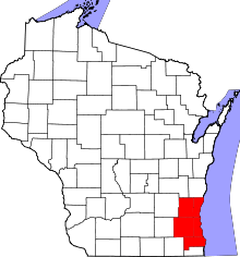 | |
|---|---|---|
| Largest municipalities (over 25,000 in 2010) | ||
| Municipalities (over 10,000 in 2010) | ||
| Smaller municipalities (under 10,000 in 2010) | ||
| Counties | ||