Brown Deer, Wisconsin
| Brown Deer, Wisconsin | |
|---|---|
| Village | |
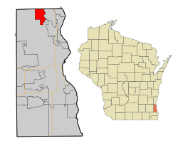 Location of Brown Deer, Wisconsin | |
| Coordinates: 43°10′22″N 87°58′40″W / 43.17278°N 87.97778°WCoordinates: 43°10′22″N 87°58′40″W / 43.17278°N 87.97778°W | |
| Country | United States |
| State | Wisconsin |
| County | Milwaukee |
| Area[1] | |
| • Total | 4.40 sq mi (11.40 km2) |
| • Land | 4.40 sq mi (11.40 km2) |
| • Water | 0 sq mi (0 km2) |
| Elevation[2] | 692 ft (211 m) |
| Population (2010)[3] | |
| • Total | 11,999 |
| • Estimate (2012[4]) | 12,088 |
| • Density | 2,727.0/sq mi (1,052.9/km2) |
| Time zone | Central (CST) (UTC-6) |
| • Summer (DST) | CDT (UTC-5) |
| Area code(s) | 414 |
| FIPS code | 55-10375[5] |
| GNIS feature ID | 1562261[2] |
| Website |
www |
Brown Deer is a village in Milwaukee County, Wisconsin, United States. As a suburb of Milwaukee, it is part of the Milwaukee metropolitan area. The population was 11,999 at the 2010 census.
History
The village incorporated on January 20, 1955 from a portion of the former town of Granville.[6] In August 2013, the village was listed as 19th on CNNMoney's rankings of Best Places to Live - Where Homes Are Affordable, the highest ranking community in the state of Wisconsin.[7]
Geography
Brown Deer is located at 43°10′22″N 87°58′40″W / 43.17278°N 87.97778°W (43.172858, -87.977899).[8]
According to the United States Census Bureau, the village has a total area of 4.40 square miles (11.40 km2), all of it land.[1]
Demographics
| Historical population | |||
|---|---|---|---|
| Census | Pop. | %± | |
| 1960 | 11,280 | — | |
| 1970 | 12,582 | 11.5% | |
| 1980 | 12,921 | 2.7% | |
| 1990 | 12,236 | −5.3% | |
| 2000 | 12,170 | −0.5% | |
| 2010 | 11,999 | −1.4% | |
| Est. 2015 | 12,102 | [9] | 0.9% |
As of 2000 the median income for a household in the village was $61,097. The per capita income for the village was $28,525. About 5.8% people of all ages live below the poverty line. The median value of owner occupied housing units was $175,600.
2010 census
As of the census[5] of 2010, there were 11,999 people, 5,275 households, and 3,199 families residing in the village. The population density was 2,729.5 people per square mile (1,694.5/km²). There were 5,579 housing units at an average density of 1,267.95 per square mile (787.8/km²). The racial makeup of the village was 61.9% White, 28.6% African American, 0.04% Native American, 4.9% Asian, 0.1% Pacific Islander, 0.01% from other races, and 3.1% from two or more races. Hispanic or Latino of any race were 3.9% of the population.
Brown Deer is one of only four Milwaukee suburbs (Racine, Glendale, and West Milwaukee being the others) where African-Americans make up at least 10% of the general population.
There were 5,275 households of which 26.4% had children under the age of 18 living with them, 45.5% were married couples living together, 11.4% had a female householder with no husband present, and 39.4% were non-families. 33.7% of all households were made up of individuals living alone and 12.5% had someone living alone who was 65 years of age or older. The average household size was 2.27 and the average family size was 2.91.
In the village the population was spread out with 20.9% under the age of 18, 7.5% from 18 to 24, 12.8% from 25 to 34, 20.7% from 35 to 49, 21.5% from 50-64, and 16.6% who were 65 years of age or older. The median age was 41.8 years. 52% of the population was female and 48% was male.
Education
Algonquin Elementary School was formerly located on N. 47th Street. It served kindergarten through 2nd grade until it was closed in 2007.[11]
In 2007, the Brown Deer Schools merged Algonquin into Dean Elementary School (which formerly taught only K4 to 4th grade); and merged the former Brown Deer Middle School (5th to 8th grades) and Brown Deer High School (9th to 12th grades).
Dean Elementary School was formerly located on N. 55th Street. It served kindergarten through sixth graders but was closed and torn down in 2013.[12]
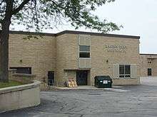
Brown Deer Middle School/High School and Brown Deer Elementary School are located on N. 60th Street. Enrollment is about 1600 students in grades K through 12.[13]
Notable residents
- Bruce Froemming, Major League Baseball umpire
- Dan Harmon, comedian and writer
- Steve Novak, basketball player
- Ervin Schneeberger, businessman and member of the Wisconsin State Assembly, was born in Brown Deer.[14]
Notes
- 1 2 "US Gazetteer files 2010". United States Census Bureau. Archived from the original on 2012-07-14. Retrieved 2012-11-18.
- 1 2 "US Board on Geographic Names". United States Geological Survey. 2007-10-25. Retrieved 2008-01-31.
- ↑ "American FactFinder". United States Census Bureau. Retrieved 2012-11-18.
- ↑ "Population Estimates". United States Census Bureau. Archived from the original on 2013-06-17. Retrieved 2013-06-24.
- 1 2 "American FactFinder". United States Census Bureau. Archived from the original on 2013-09-11. Retrieved 2008-01-31.
- ↑ "VILLAGE HISTORY" Archived March 12, 2007, at the Wayback Machine., from the Village of Brown Deer, Wisconsin website
- ↑ http://money.cnn.com/gallery/real_estate/2013/08/12/best-places-affordable-homes.moneymag/19.html
- ↑ "US Gazetteer files: 2010, 2000, and 1990". United States Census Bureau. 2011-02-12. Retrieved 2011-04-23.
- ↑ "Annual Estimates of the Resident Population for Incorporated Places: April 1, 2010 to July 1, 2015". Retrieved July 2, 2016.
- ↑ "Census of Population and Housing". Census.gov. Archived from the original on May 11, 2015. Retrieved June 4, 2015.
- ↑
- ↑
- ↑
- ↑ 'Wisconsin Blue Book 1970,' Biographical Sketch of Ervin Schneeberger, pg. 56
External links
Municipalities and communities of Milwaukee County, Wisconsin, United States | ||
|---|---|---|
| Cities | 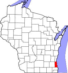 | |
| Villages | ||
| Ghost towns/ neighborhoods | ||
| Indian reservation | ||
| Footnotes | ‡This populated place also has portions in another county or counties | |
| Central city |  | |
|---|---|---|
| Largest municipalities (over 25,000 in 2010) | ||
| Municipalities (over 10,000 in 2010) | ||
| Smaller municipalities (under 10,000 in 2010) | ||
| Counties | ||