Big Bend, Waukesha County, Wisconsin
- There are some other places named: Big Bend.
| Big Bend | |
|---|---|
| Village | |
 Location in Waukesha County and the state of Wisconsin. | |
| Coordinates: 42°53′16″N 88°12′41″W / 42.88778°N 88.21139°WCoordinates: 42°53′16″N 88°12′41″W / 42.88778°N 88.21139°W | |
| Country | United States |
| State | Wisconsin |
| County | Waukesha |
| Area[1] | |
| • Total | 3.15 sq mi (8.16 km2) |
| • Land | 3.11 sq mi (8.05 km2) |
| • Water | 0.04 sq mi (0.10 km2) |
| Population (2010)[2] | |
| • Total | 1,290 |
| • Estimate (2012[3]) | 1,297 |
| • Density | 414.8/sq mi (160.2/km2) |
| Time zone | Central (CST) (UTC-6) |
| • Summer (DST) | CDT (UTC-5) |
| Area code(s) | 262 |
| Website | http://www.villageofbigbend.com |
Big Bend is a village in Waukesha County, Wisconsin, United States. The population was 1,290 at the 2010 census.
Geography
Big Bend is located at 42°53′16″N 88°12′41″W / 42.88778°N 88.21139°W (42.887862, -88.211333).[4]
According to the United States Census Bureau, the village has a total area of 3.15 square miles (8.16 km2), of which, 3.11 square miles (8.05 km2) of it is land and 0.04 square miles (0.10 km2) is water.[1]
Demographics
| Historical population | |||
|---|---|---|---|
| Census | Pop. | %± | |
| 1930 | 309 | — | |
| 1940 | 298 | −3.6% | |
| 1950 | 480 | 61.1% | |
| 1960 | 797 | 66.0% | |
| 1970 | 1,148 | 44.0% | |
| 1980 | 1,345 | 17.2% | |
| 1990 | 1,299 | −3.4% | |
| 2000 | 1,278 | −1.6% | |
| 2010 | 1,290 | 0.9% | |
| Est. 2015 | 1,312 | [5] | 1.7% |
2010 census
As of the census[2] of 2010, there were 1,290 people, 486 households, and 375 families residing in the village. The population density was 414.8 inhabitants per square mile (160.2/km2). There were 503 housing units at an average density of 161.7 per square mile (62.4/km2). The racial makeup of the village was 97.9% White, 0.2% African American, 0.2% Native American, 0.5% Asian, 0.1% Pacific Islander, 0.1% from other races, and 1.1% from two or more races. Hispanic or Latino of any race were 2.3% of the population.
There were 486 households of which 35.4% had children under the age of 18 living with them, 63.4% were married couples living together, 9.1% had a female householder with no husband present, 4.7% had a male householder with no wife present, and 22.8% were non-families. 16.9% of all households were made up of individuals and 5.7% had someone living alone who was 65 years of age or older. The average household size was 2.65 and the average family size was 3.00.
The median age in the village was 40.8 years. 23.9% of residents were under the age of 18; 7.4% were between the ages of 18 and 24; 24.6% were from 25 to 44; 33.1% were from 45 to 64; and 11.1% were 65 years of age or older. The gender makeup of the village was 49.8% male and 50.2% female.
2000 census
As of the census of 2000, there are 1,278 people, 448 households, and 348 families residing in the village. The population density is 564.6 people per square mile (218.3/km²). There are 457 housing units at an average density of 201.9/sq mi (78.1/km²). The racial makeup of the village is 97.26% White, 0.47% African American, 0.55% Native American, 0.23% Asian, 0.39% Pacific Islander, 0.39% from other races, and 0.70% from two or more races. 1.80% of the population are Hispanic or Latino of any race.
There were 448 households out of which 37.5% had children under the age of 18 living with them, 66.1% were married couples living together, 6.9% had a female householder with no husband present, and 22.1% were non-families. 17.6% of all households were made up of individuals and 7.8% had someone living alone who was 65 years of age or older. The average household size was 2.85 and the average family size was 3.21.
In the village the population was spread out with 28.9% under the age of 18, 7.0% from 18 to 24, 30.0% from 25 to 44, 25.0% from 45 to 64, and 9.0% who were 65 years of age or older. The median age was 37 years. For every 100 females there were 106.5 males. For every 100 females age 18 and over, there were 107.5 males.
The median income for a household in the village was $56,767, and the median income for a family was $61,771. Males had a median income of $40,583 versus $26,528 for females. The per capita income for the village was $22,072. About 0.9% of families and 2.9% of the population were below the poverty line, including 5.0% of those under age 18 and 1.7% of those age 65 or over.
Notable people
- David Craig, politician[7]
- Delbert K. Smith, Wisconsin politician, was born in Big Bend.[8]
- James Tormey, Wisconsin politician[9]
References
- 1 2 "US Gazetteer files 2010". United States Census Bureau. Archived from the original on January 24, 2012. Retrieved 2012-11-18.
- 1 2 "American FactFinder". United States Census Bureau. Retrieved 2012-11-18.
- ↑ "Population Estimates". United States Census Bureau. Archived from the original on June 17, 2013. Retrieved 2013-06-24.
- ↑ "US Gazetteer files: 2010, 2000, and 1990". United States Census Bureau. 2011-02-12. Retrieved 2011-04-23.
- ↑ "Annual Estimates of the Resident Population for Incorporated Places: April 1, 2010 to July 1, 2015". Retrieved July 2, 2016.
- ↑ "Census of Population and Housing". Census.gov. Archived from the original on May 11, 2015. Retrieved June 4, 2015.
- ↑ 'Wisconsin Blue Book 2011-2012,' Biographical Sketch of David Craig, pg.75
- ↑ 'Wisconsin Blue Book 1897,' Biographical Sketch of Delbert K. Smith, pg. 698
- ↑ THE BLUE BOOK OF THE STATE OF WISCONSIN. 1891. p. 598.
External links
Municipalities and communities of Waukesha County, Wisconsin, United States | ||
|---|---|---|
| Cities | 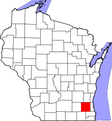 | |
| Villages | ||
| Towns | ||
| CDP | ||
| Unincorporated communities | ||
| Ghost towns | ||
| Footnotes | ‡This populated place also has portions in an adjacent county or counties | |
| Central city |  | |
|---|---|---|
| Largest municipalities (over 25,000 in 2010) | ||
| Municipalities (over 10,000 in 2010) | ||
| Smaller municipalities (under 10,000 in 2010) | ||
| Counties | ||