Quirino Avenue
| Quirino Avenue | |
|---|---|
|
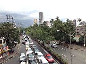
Looking west towards Malate from Quirino LRT Station | |
| Route information | |
| Length: | 3.6 km (2.2 mi) |
| Component highways: |
|
| Major junctions | |
| North end: | Lacson Avenue in Paco |
|
Paco-Santa Mesa Road Pedro Gil Street Osmeña Highway (SLEX) Taft Avenue West Zamora Street East Zamora Street | |
| South end: | Roxas Boulevard in Malate |
| Highway system | |
| Highways in the Philippines | |
President Elpidio Quirino Avenue, more commonly known as Quirino Avenue, is a 6-10 lane divided highway in Manila, Philippines. It runs for 3.6 kilometers (2.2 miles) in a northeast-southwest direction from Nagtahan Bridge (now Mabini Bridge) across from Santa Mesa in the north to Roxas Boulevard in Malate in the south. It passes through Paco and Pandacan districts where it also serves as a truck route between Port Area and South Luzon Expressway. North of Nagtahan Bridge, the road continues as Lacson Avenue. It is designated as part of Circumferential Road 2.
History
Its construction dates back to the early 19th century under Spanish rule when Quirino Avenue Extension was first laid out as Calle Canonigo in Paco.[1] The road leading to Nagtahan Bridge then was a narrow street called Calle Luengo in Pandacan.[2]
By the late 1920s, under the United States' Insular Government, the Paco-Santa Mesa Road was constructed which was later renamed Tomás Claudio Street. Following the Burnham Plan for Manila, the road was further extended to meet Harrison Boulevard that ran southwest from Calle Herrán (now Pedro Gil Street) up to Dewey Boulevard (now Roxas Boulevard). The whole length of the highway that forms part of Circumferential Road 2 was later named in honor of the sixth President of the Philippines, Elpidio Quirino.
Route description

- Nagtahan Bridge to Paco-Santa Mesa Road section
The northern end of Quirino Avenue is at the intersection of Paz Mendoza Guazon (Otis) and Jesus Streets in Paco, at the foot of the Nagtahan Bridge as a continuation of Lacson Avenue. Jesus Street leads to the Pandacan oil depot to the east while Guazon leads to Malacañang Park and Robinsons Otis to the west. Heading south, it enters Pandacan district moving past primarily residential areas on both sides, with Zamora Market on the west side. The avenue then curves southwest following the alignment of the Philippine National Railways line, where it merges with traffic from Paco-Santa Mesa Road or Tomas Claudio Street.
- Paco-Santa Mesa Road to Osmeña Highway section
South of the junction with Tomas Claudio, the avenue traverses the district of Paco where the Old Paco station and Plaza Dilao are located. Also located along this stretch are the Philippine Columbian Association complex on Plaza Dilao and the new Paco railway station near the intersection with Pedro Gil Street. It follows a straight path south towards the border with Malate where it is joined by Osmeña Highway (South Luzon Expressway).
- Osmeña Highway to Roxas Boulevard section
The Malate section of Quirino Avenue is primarily residential and commercial. The Singalong area lies directly south of the Osmeña Highway junction just before it intersects with Taft Avenue, where the elevated Quirino LRT Station is located. South of Taft Avenue, Quirino provides access to the tourism center of Malate where the Remedios Circle, Manila Zoo, Baywalk, San Andres Sports Complex, Plaza Rajah Sulayman and Malate Church are located. It curves westwards past Adriatico Street until it meets its southern terminus at Roxas Boulevard near Manila Yacht Club and Ospital ng Maynila Medical Center.
- Quirino Avenue Extension
Quirino Avenue extends to the industrial area of Paco (Otis) and United Nations Avenue from a loop road around Plaza Dilao just off the main highway on the north side of its short Paco segment. This is the main truck route going in and out of Port Area from South Luzon Expressway.
Landmarks


- Aloha Hotel
- Asociacion de Damas de Filipinas
- Bureau of Plant Industry
- Jacinto Zamora Elementary School
- Manila Zoological and Botanical Garden
- Old Paco railway station
- Ospital ng Maynila Medical Center
- Malacañang Hospital
- Manuel Roxas High School
- Paraiso ng Batang Maynila Park
- Philippine Columbian Association
- Plaza Dilao
- President Elpidio Quirino Monument
- Saint Peter the Apostle School
- San Andres Market
- Zamora Market
See also
References
- ↑ History of San Fernando de Dilao published by the Roman Catholic Archdiocese of Manila; accessed 2013-10-09.
- ↑ 1945 Map of Central Manila published by BattleofManila.org; accessed 2013-10-09.
| Wikimedia Commons has media related to Quirino Avenue. |
Coordinates: 14°34′33″N 120°59′46″E / 14.57583°N 120.99611°E