Taft Avenue
| Taft Avenue | |
|---|---|
|
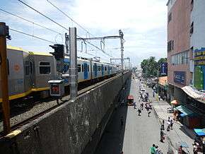
Taft Avenue runs below the elevated Manila LRT Line 1 | |
| Route information | |
| Component highways: |
|
| Major junctions | |
| North end: | Padre Burgos Street(Manila City Hall) in Manila |
|
Epifanio de los Santos Avenue in Pasay Arnaiz Avenue (Libertad Street) in Pasay Gil Puyat Avenue (Buendia) in Pasay Ocampo Street (Vito Cruz), Quirino Avenue in Manila, San Andres St. in Manila Pedro Gil Street (Herran) in Manila United Nations Avenue in Manila | |
| South end: | Redemptorist Road(Baclaran)(borders of Pasay and Parañaque) |
| Location | |
| Major cities: | Parañaque, Pasay, Manila |
| Highway system | |
| Highways in the Philippines | |
Taft Avenue is a major road thoroughfare in Metro Manila. It crosses through three major cities of the capital region: Manila, Pasay and Parañaque. The road was named after the former Governor-General of the Philippines and U.S President, William Howard Taft. The Philippines was a former commonwealth territory of the United States in the first half of the twentieth century.
History
Construction of this avenue, originally called "Calle Rizal", was completed in 1899, with Padre Burgos Street (C-1) as its northern terminus and Calle Herran (now Pedro Gil Street) as its southern terminus. Engineers Manny Aquino and Robin Santos led its extension in 1911, and the avenue was renamed Manila Road. However, a map of Manila produced in 1915 by the Office of Department Engineer, Philippine Department, indicates it was named Taft Avenue.[1] It was extended to Ocampo Street (formerly Vito Cruz Street in 1940, at the height of World War II, during the Japanese occupation of the Philippines. It was further extended to Buendia Avenue (now Gil Puyat Avenue) in 1959 and was named 'Ermita-Pasay Boulevard' or Highway 50, and was further extended to P. Lovina Street or Highway 54 Extension where it ends, with the route continuing as Mexico Road. It was renamed Taft Avenue in 1984 and it also reclaimed Mexico Road. The Manila LRT Line 1, the first elevated rail track in the Philippines, was built over it and opened in that same year.
Intersections

This Avenue has Intersections. If Bold had a Street Crossings.
Ermita, Manila
- Padre Burgos Street (Taft Avenue Extension) (C-1, R-2 & R-7)
- Mayor Antonio J. Villegas Road (Calle Arroceros)
- Finance Street / Ayala Boulevard (Aurora Boulevard Extension) (R-6 & C-1)
- Kalaw Avenue (Calle San Luis) (R-7)
- United Nations Avenue (Calle Issac Peral) / General Luna Street
- Padre Faura Street
- G. Apacible Street (Calle Oregon)
- Josefa Llanes Escoda Street (Calle California)
- Pedro Gil Street (Calle Herran) (R-4)
- General M Malvar Street (Calle Tennessee)
Malate, Manila
- Julio Nakpil Street (Calle Vermont)
- Remedios Street
- Quirino Avenue (Harrison Boulevard) (C-2) / San Andres Street
- Dagonoy Street
- Sagrada Pamilya Street
- Ocampo Street (Calle Vito Cruz)
Pasay City
- Menlo Street
- Inquimboy Street
- Leogrado Street
- Bonifacio Street
- Bernabe Street
- Lakas ng Bayan Street
- San Juan Street
- P. Samonte Street
- Gil Puyat Avenue (Buendia Avenue) (C-3)
- G. Villanueva Street
- Cartimar Avenue
- Taylo Street
- College Road
- Villareal Street
- Arnaiz Avenue (Libertad Street)
- Primero De Mayo Street
- Lions Road
- Protacio Street
- F. Sanchez Street
- Vergel Street / Pilapil Street (Vergel Street)
- Epifanio de los Santos Avenue (F. Rein Street) (C-4)
- Cuneta Avenue
- Narra Street
- Park Avenue
Parañaque City
- Harrison Avenue / Elpidio Quirino Avenue (Taft Avenue Extension) / Redemptorist Road (R-2)
Direction

Taft Avenue starts from Elpidio Quirino Avenue in the city of Parañaque, then transversing northeast to Epifanio de los Santos Avenue (EDSA) in Pasay, then north to Arnaiz Avenue (formerly known as Libertad/Pasay Road), Gil Puyat Avenue (formerly known as Buendia), Pablo Ocampo Street (formerly known as Vito Cruz), Quirino Avenue, San Andres Street in Manila, Pedro Gil Street (formerly known as Herran), Padre Faura Street, United Nations Avenue, Kalaw Avenue and Finance Road. The avenue straight ahead would be later known as Padre Burgos Avenue and spurs into three bridges then streets: Quezon Boulevard, Rizal Avenue, and Quintin Paredes Street.
Attractions
Rizal Park
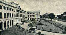
One of the two entrances to Rizal Park, (the other being Roxas Boulevard), the Taft Avenue entrance is also adjacent to the National Museum of the Philippines: which is located in two buildings, namely, the National Art Gallery (formerly Legislative Building) and the Museum of the Filipino People (formerly the Finance Building), and the Statue of Sultan Kudarat.
Government buildings
Taft Avenue is home (or near) to some government buildings: the Supreme Court of the Philippines, Court of Appeals, Department of Tourism, Bureau of Plant Industry, Philippine General Hospital, and the National Bureau of Investigation.
World Health Organization
The office of the World Health Organization Western Pacific Region is located on Taft Avenue, adjacent the LRT-1 United Nations Station.
University Belt
Taft Avenue forms a part of the University Belt. Universities such as the De La Salle University, University of the Philippines Manila, Philippine Christian University, Philippine Women's University and the Philippine Normal University are located on Taft Avenue. The College of Saint Benilde, Santa Isabel College Manila, Emilio Aguinaldo College, Araullo High School and the Manila Science High School also directly faces the road.
National Cathedral of the Philippine Independent Church
The National Cathedral of the Holy Child (Holy Infant Jesus) of the Philippine Independent Church is located on Taft Avenue.
Transportation
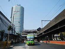
Taft Avenue is accessed through jeepneys, taxis, the Manila LRT Line 1 and the Manila MRT Line 3. The avenue houses some stations of the LRT-1 namely: EDSA (interchange at the MRT-3 Taft Avenue Station), Libertad, Gil Puyat, Vito Cruz, Quirino Avenue, Pedro Gil, United Nations.
References
- ↑ "Map of city of Manila and vicinity". Library of Congress.
| Wikimedia Commons has media related to Taft Avenue. |
Coordinates: 14°33′51″N 120°59′39″E / 14.56417°N 120.99417°E