Magsaysay Boulevard
| Magsaysay Boulevard | |
|---|---|
 | |
| Route information | |
| Length: | 2.2 km (1.4 mi) |
| Component highways: |
|
| Major junctions | |
| West end: | Lacson Avenue and Legarda Street |
|
Pureza Street Old Santa Mesa Street Victorino Mapa Street | |
| East end: | Gregorio Araneta Avenue and Aurora Boulevard |
| Highway system | |
| Highways in the Philippines | |
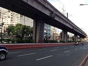
President Ramon Magsaysay Boulevard, simply known Magsaysay Boulevard, is the principal artery of Santa Mesa in Manila, Philippines. It is a six-lane divided roadway that travels east-west from Gregorio Araneta Avenue near the city's border with Quezon City and San Juan to Lacson Avenue and Nagtahan flyover close to the district of San Miguel. The entire length of the boulevard serves as the boundary between Sampaloc in the north and Santa Mesa in the south with the Manila Light Rail Transit System Line 2 running along its median. East of Gregorio Araneta, the road continues as Aurora Boulevard while west of Lacson, it extends as Legarda Street via a flyover into San Miguel and Quiapo.
The Manila LRT Line 2 has two stations along Magsaysay, namely Pureza and V. Mapa. It is also served by the Santa Mesa railway station near the Polytechnic University of the Philippines campus on Hipodromo and Anonas Streets.
The boulevard was named after the seventh president of the Philippines, Ramon Magsaysay. It was formerly called Santa Mesa Boulevard.[1]
Landmarks

- Hotel Sogo Sta. Mesa
- Isetann Wholesale Store
- Metropolitan Manila Development Authority Traffic Engineering Center
- National Statistics Office–NCR
- Central Colleges of the Philippines Graduate School
- Sacred Heart of Jesus Catholic School
- Sacred Heart of Jesus Parish Church
- Santa Mesa Market
- SM City Santa Mesa
- SM Mezza Residences
- SM Savemore Nagtahan
See also
References
- ↑ Sta. Mesa: Manila's northeastern edge published by the Philippine Star; accessed 2013-10-10.
Coordinates: 14°36′7″N 121°0′31″E / 14.60194°N 121.00861°E