Tomas Morato Avenue
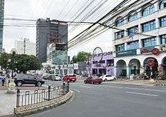 Tomas Morato Avenue, at the intersection of Scout Delgado Street | |
| Length | 1.6 km (1.0 mi) |
|---|---|
| Location | Quezon City |
| North end | Eugenio Lopez Drive in South Triangle |
| Major junctions |
Timog Avenue Don Alejandro Roces Avenue Kamuning Road |
| South end | Eulogio Rodriguez Sr. Avenue in Mariana |
Tomas Morato Avenue is a street located in Quezon City within the Diliman and New Manila areas of northeastern Metro Manila, Philippines. The street links Eulogio Rodriguez Sr. Avenue in the village of Mariana in the south with Eugenio Lopez Drive (formerly Scout Albano Street) in South Triangle in the north, and passes through Sacred Heart, Laging Handa, Kamuning, Obrero and Kristong Hari villages. It was named after the first mayor of Quezon City.
The street is known as a restaurant row located in Quezon City's entertainment area along with Timog Avenue and West Avenue.[1] It is also known for its bars, discos, karaoke and comedy clubs, and as a popular hangout for local actors who work in the nearby studios such as the ABS-CBN Broadcasting Center on Mother Ignacia Avenue and GMA Network Center on Timog Avenue.
History
The street, which opened around 1940, was originally named Sampaloc Avenue. It was so named because of the prevalence of tamarind trees which lined the street in the early days. It is believed that the trees were planted by Tomas Morato himself along with former president Manuel Luis Quezon and journalist Alejandro Roces.[2] As of 2012, however, only two sampaloc trees remain, as they have been cut down over the years to make way for parking spaces.[2][3]
In 1966, the avenue was renamed to honor Morato, the city's first mayor under whose term the road was constructed.[4][5] By the 1990s, the street was transformed into a trendy hot spot with bars lining the street such as the popular Tia Maria's.[3] In 1996, one of the deadliest nightclub fires occurred at the Ozone Disco Club on Tomas Morato and Timog Avenue. In 2003, the street underwent a major renovation with the sidewalk improved and railings installed along corners of the avenue to prevent double parking.[6]
Description

Tomas Morato Avenue runs in a north-south direction and has four lanes, two lanes going in each direction. Beginning at the intersection with Eulogio Rodriguez Sr. Avenue in New Manila, the road traverses Kristong Hari village and quickly enters the Diliman villages of Obrero and Kamuning towards the junction with Kamuning Road. Upon crossing the Don Alejandro Roces Avenue (former Calle Retiro), it enters the Scout areas, home to most of the street's famous restaurants and bars including Thompson Square, where the road serves as the border between Laging Handa and Sacred Heart villages up to the intersection with Timog Avenue. The streets in this area were named in honor of the 22 Boy Scouts who died in a plane crash en route to joining the 11th World Scout Jamboree. A memorial stands in the center of the rotunda at the intersection of Tomas Morato with Timog Avenue. Near the scouting memorial is the location of the former Ozone disco. Past the memorial rotunda, the avenue enters the village of South Triangle where the Il Terrazzo strip mall, Imperial Palace Hotel and Hotel Rembrandt are located. It ends at a T-intersection with Eugenio Lopez Drive by the ABS-CBN Main Building.
References
- ↑ "Business brings more fun in Quezon City". Quezon City Business. Retrieved 12 May 2015.
- 1 2 "The vanishing sampaloc trees along Tomas Morato Avenue in Quezon City". GMA Network News. Retrieved 12 May 2015.
- 1 2 "Lifestyle mini guide to Morato Avenue's changing foodscape". Philippine Daily Inquirer. Retrieved 12 May 2015.
- ↑ "Republic Act No. 4749". Chan Robles Virtual Law Library. Retrieved 11 May 2015.
- ↑ "Milestones in History". Quezon City Government. Retrieved 12 May 2015.
- ↑ "Morato Avenue is public domain – City Hall". The Philippine Star. Retrieved 12 May 2015.
Coordinates: 14°37′53″N 121°02′04″E / 14.6313889°N 121.0344444°E