Andrews Avenue
| Nichols Road | |
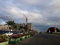 Looking east along Andrews Avenue near Resorts World Manila | |
| Length | 4.3 km (2.7 mi) |
|---|---|
| Location | Parañaque, Pasay, Taguig |
| West end | Roxas Boulevard in Baclaran |
| Major junctions |
Domestic Road Tramo Street (Aurora Boulevard) |
| East end | South Luzon Expressway in Fort Bonifacio |
Andrews Avenue is a major east-west thoroughfare in Metro Manila, Philippines that functions as a metropolitan linkage between Pasay and Taguig.[1] It runs underneath the under-construction NAIA Expressway almost parallel to Epifanio de los Santos Avenue (EDSA) to the north connecting Roxas Boulevard and Domestic Road near Bay City with South Luzon Expressway near Newport City. It has an arterial extension continuing 3.4 kilometers (2 miles) northeast to Fifth Avenue and McKinley Road in Bonifacio Global City known as Lawton Avenue.
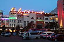
Andrews Avenue also serves as the main feeder to Ninoy Aquino International Airport from the east and west and is the main access road to Resorts World Manila.
History
The avenue was formerly called Nichols Field Road,[2] later shortened to Nichols Road, after the US air base in Pasay which it served. Nichols Field, in turn, was named after Captain Henry E. Nichols, a US Navy commander of monitor ship USS Monadnock during the Philippine-American War.[3][4] The air base was built in 1912[5] and the road to Fort McKinley (now Fort Bonifacio) and to Dewey Boulevard (now Roxas Boulevard) was constructed shortly thereafter. The whole stretch from Dewey to Fort McKinley was named Nichols Road.[6]
At present, the Fort Bonifacio/Taguig portion is named Lawton Avenue. In Pasay, the longest portion has been renamed to Andrews Avenue, after Frank Maxwell Andrews, the United States Army general officer during World War II and one of the founders of the United States Army Air Force.
Route description


Andrews Avenue follows the old route of Nichols Road in Pasay and is split into three sections.
- Sales Road
At its eastern terminus, the route begins as Sales Road at the Sales Interchange with the South Luzon Expressway, near the Nichols railway station. It is a continuation of Lawton Avenue from Fort Bonifacio via the Sales Bridge and a roundabout. It runs for approximately 900 meters as it heads southwesterly across the Villamor Air Base and Villamor Golf Course toward Ninoy Aquino International Airport (NAIA) Terminal 3. This section ends with another roundabout at the foot of the NAIA Expressway NAIA-3 off-ramp just before the road makes a sharp bend to the west.
- Andrews Avenue
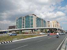
The main section of Andrews Avenue is an eight-lane divided arterial that runs along the northern perimeter of the airport. From the roundabout across from the Philippine Air Force Aerospace Museum, the avenue continues along the southern side of Newport City, a mixed-use development facing the NAIA Terminal 3. It passes the integrated resort complex of Resorts World Manila, the Star Cruises Centre and the Shrine of St. Therese before reaching a large roundabout with a prominent "egg structure" in the middle called Circulo del Mundo.[7] Access to the airport terminal is via this roundabout which also serves as a boundary between Newport and the older barangays of Pasay. From Circulo down to the intersection with Domestic Road, the avenue is lined with airline offices and maintenance facilities, as well as a few barangays in between. The Manila Light Rail Transit facilities are also located in this intersection before the avenue becomes known as Airport Road.
- Airport Road
West of Domestic Road and a small creek called Estero de Tripa de Gallina, the road enters the Baclaran area of Parañaque. The road narrows into a four-lane undivided road carrying one-way westbound traffic. The road meets its western terminus at Roxas Boulevard.
Points of interest
- Circulo del Mundo
- Civil Aviation Authority of the Philippines
- Fort Bonifacio
- Marriott Hotel Manila
- Maxims Hotel
- Newport Mall
- Philippine Air Force Aerospace Museum
- Philippine Air Force General Hospital
- Remington Hotel
- Resorts World Manila
- Shrine of St. Therese
- Star Cruises Centre
- Villamor Air Base
- Villamor Golf Course
See also
References
- ↑ Roads and Transport published by the Pasay City Government; accessed 2013-10-14.
- ↑ Manila American Cemetery and Memorial Archived October 16, 2013, at the Wayback Machine. published by American Battle Monuments Commission; accessed 2013-10-14.
- ↑ Nichols Field - Ensconced in Philippine aviation history published by Lufthansa Technik Philippines; accessed 2013-10-14.
- ↑ Captain Henry Nichols died on the USS Monadnock in 1899 published by Ancestry.com; accessed 2013-10-14.
- ↑ Villamor Air Base Archived October 16, 2013, at the Wayback Machine. published by the Philippine Air Force; accessed 2013-10-14.
- ↑ Series S501, U.S. Army Map Service, 1954- published by the University of Texas at Austin; accessed 2013-10-14.
- ↑ Ex-MMDA chair Bayani Fernando says "egg structure" across NAIA was built for P50 million, not P390 million published by Spot.ph; accessed 2013-10-14.
Coordinates: 14°31′25″N 121°0′39″E / 14.52361°N 121.01083°E