Pittston Township, Luzerne County, Pennsylvania
| Pittston Township, Pennsylvania | |
|---|---|
| Township | |
|
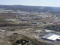
Aerial view of Pittston Township's growing commercial district | |
 Map of Luzerne County, Pennsylvania Highlighting Pittston Township | |
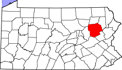 Map of Luzerne County, Pennsylvania | |
| Country | United States |
| State | Pennsylvania |
| County | Luzerne |
| Region | Greater Pittston |
| Settled | 18th century |
| Established | 1790 |
| Government | |
| • Supervisor | Frank Sciabacucchi |
| • Supervisor | Stephen Rinaldi |
| • Supervisor | Barbara Attardo |
| Area | |
| • Total | 13.79 sq mi (35.71 km2) |
| • Land | 13.77 sq mi (35.66 km2) |
| • Water | 0.02 sq mi (0.05 km2) |
| Population (2010) | |
| • Total | 3,368 |
| • Density | 240/sq mi (94/km2) |
| Time zone | Eastern (EST) (UTC-5) |
| • Summer (DST) | EDT (UTC-4) |
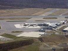
Pittston Township is a township in Luzerne County, Pennsylvania, United States. The township is located within the Greater Pittston metro area. The population was 3,368 at the 2010 census.[1] The Wilkes-Barre/Scranton International Airport is located in Pittston Township.
History
Pittston Township is one of the five original townships formed under Connecticut. Its existence dates back to 1768. Originally spelled Pittstown, it was named for Sir William Pitt, an English statesman. It is situated in the northeast portion of Luzerne County. Each township was only five square miles and was divided amongst forty settlers.
Pittston Township was one of five townships of the Susquehanna Land Company. The township was surveyed in 1768. But in 1784, flood waters destroyed the surveyor's marks and an act was passed for a new survey to take place. After being resurveyed, the township grew to nearly thirty-six square miles. The leading families who were in the township prior and during the American Revolution were Blanchards, Browns, Careys, Bennetts, Silsbeys, Marceys, Benedicts, St. Johns, Sawyers, the gallant Cooper, and Rev. Benedict, the first preacher in the locality. Captain Jeremiah Blanchard, Sr., was commander of the Pittston Company. Zebulon Marcy was the first white man that ever built a brush or log cabin in the township. Some may refer to him as the first settler.
On the morning of July 4, 1778, after the surrender of Forty Fort to the British, British Officer Butler sent a detachment across the river to Pittston and demanded the surrender of Fort Brown, which was commanded by Capt. Blanchard. The fort was capitulated on fair terms.
Dr. Nathaniel Giddings was the first physician in the settlement. He came from Connecticut in 1787, and practiced medicine here until his death in 1851. He set one of the first orchards in the township on his farm.
For sixty years, the Yankee element predominated the population of the township. When coal was discovered, a great migration of various European nationalities began. This influx is responsible for the heterogeneous population that is found today. The coal interests soon became the largest source of wealth in the township, although there is some valuable farming land in the small valleys. Col. James W. Johnson was one of the pioneers in the mining and shipping of coal. He sent considerable quantities down the river in "arks" when this was the only mode of transportation.
The first sawmill in the township was built near the mouth of the Lackawanna in 1780 by Solomon Finn & E. L. Stevens.
McCarthyville, popularly known as Cork Lane, was a mining town or collection of houses in Pittston Township. In 1892, there were 900 inhabitants and 140 dwellings. Browntown was also a mining place in Pittston Township. In 1892, the population was estimated at 1,000 and 200 dwellings. It remained an active mining region for many decades, until the 1959 Knox Mine Disaster in nearby Port Griffith ended the industry completely.[2][3]
Geography
According to the United States Census Bureau, the township has a total area of 13.79 square miles (35.71 km2), of which 13.77 square miles (35.66 km2) is land and 0.02 square miles (0.05 km2), or 0.15%, is water. It is the largest community by area in Greater Pittston. The township is served by the Pittston Area School District. The eastern part of the township is made up of mountains and forests. Most of the township's residents and businesses are located in the western half of the town. The elevation ranges from 2,130 feet (650 m) above sea level at the summit of Little Shiney Mountain in the southeastern corner of the township to 630 feet (190 m) in several valleys along the western border, near the Susquehanna River.
Its villages include Browntown, Glendale, and Suscon. Its numbered routes are U.S. Route 11, Interstate 81, Interstate 476, Route 315, and Route 502. The interstate highways connect with each other via Route 315 at the Wyoming Valley Interchange just east of Browntown. Suscon Road crosses the township from northwest to southeast, connecting the borough of Dupont with Thornhurst on the Lehigh River. Oak Street and William Street (Route 11) connect the township with the city of Pittston.
Neighborhoods of Pittston Township
Demographics
As of the census[4] of 2000, there were 3,450 people, 1,340 households, and 975 families residing in the township. The population density was 240.2 people per square mile (92.8/km2). There were 1,437 housing units at an average density of 100.1/sq mi (38.6/km2). The racial makeup of the township was 99.16% White, 0.29% African American, 0.09% Asian, 0.06% from other races, and 0.41% from two or more races. Hispanic or Latino of any race were 0.35% of the population.
There were 1,340 households, out of which 27.5% had children under the age of 18 living with them, 55.7% were married couples living together, 12.1% had a female householder with no husband present, and 27.2% were non-families. 24.4% of all households were made up of individuals, and 12.5% had someone living alone who was 65 years of age or older. The average household size was 2.54 and the average family size was 3.03.
In the township the population was spread out, with 20.9% under the age of 18, 7.2% from 18 to 24, 28.7% from 25 to 44, 25.3% from 45 to 64, and 17.9% who were 65 years of age or older. The median age was 41 years. For every 100 females there were 97.4 males. For every 100 females age 18 and over, there were 92.0 males.
The median income for a household in the township was $41,339, and the median income for a family was $47,933. Males had a median income of $32,013 versus $22,077 for females. The per capita income for the township was $18,660. About 7.1% of families and 11.6% of the population were below the poverty line, including 16.0% of those under age 18 and 16.0% of those age 65 or over.
Government
A second class township government consists of three supervisors, each with equal voting power. The three current supervisors are:
- Frank Sciabacucchi
- Stephen Rinaldi
- Barbara Attardo
Recent Pittston Township Supervisors
| Supervisor 1 | Supervisor 2 | Supervisor 3 | |||
|---|---|---|---|---|---|
| Joseph Adams | ? -2016 | Tony Attardo | 1978-2009 | John Paglianite | ? -2008 |
| Frank Sciabacucchi | 2016-present | Barbara Attardo | 2009-2010 | Ron Marcellini | 2008-2014 |
| Stephen Rinaldi | 2010-present | Barbara Attardo | 2014-present |
Transportation
_map.svg.png)
Highways
Interstate 81 passes through Pittston Township. Interstate 81, Interstate 59 and a portion of Interstate 75 follow U.S. Route 11 for its entire journey from New Orleans, Louisiana to northern New York state. I-81 does not enter major metropolitan areas; it instead serves smaller cities such as Roanoke and Winchester, Virginia; Hagerstown, Maryland; Harrisburg, Wilkes-Barre and Scranton, Pennsylvania; and Binghamton and Syracuse, New York. After passing through Watertown, New York, Interstate 81 crosses the St. Lawrence Seaway to meet Highway 401 in Canada. Pittston Township is also located near the Northeast Extension of the Pennsylvania Turnpike, Interstate 476, providing service from Clarks Summit to Philadelphia.
Air
The Wilkes-Barre/Scranton International Airport is located in Pittston Township. The airport is served by eight international airlines and has hosted Air Force One on regional presidential visits several times in the past. In the spring of 2002, the airport began offering an increased number of non-stop flights across the nation. Service is provided by Continental Airlines, Delta, Northwest Airlines, United Airlines, and US Airways.
Public transportation
Pittston Township is served by the Luzerne County Transportation Authority and COLTS, which provides bus service to the city and other communities within Luzerne County and Lackawanna County. Martz Trailways also provides commuter, tour, and trip service from Pittston, Wilkes-Barre and Scranton to points east and south, such as Philadelphia, New York City, and Atlantic City.
Rail
The Reading Blue Mountain & Northern Railroad, Canadian Pacific Railway (successor to the Delaware and Hudson) and the Luzerne & Susquehanna Railroad (designated operator of the county-owned shortline) provide freight service within Pittston City and Pittston Township. A proposed nearby commuter train from Scranton to New York City has received government funding.
References
- ↑ "Profile of General Population and Housing Characteristics: 2010 Demographic Profile Data (DP-1): Pittston township, Luzerne County, Pennsylvania". U.S. Census Bureau, American Factfinder. Retrieved April 18, 2012.
- ↑ http://www.pagenweb.org/~luzerne/patk/pits.htm
- ↑ http://pittstontownship.org/about/3-history
- ↑ "American FactFinder". United States Census Bureau. Retrieved 2008-01-31.
Coordinates: 41°18′00″N 75°42′59″W / 41.30000°N 75.71639°W
External links
- Pittston Township official website
- Pittston Township Volunteer Fire Department
- Pittston Township Volunteer Ambulance Association & Emergency Medical Services
Municipalities and communities of Luzerne County, Pennsylvania, United States | ||
|---|---|---|
| Cities | | |
| Boroughs |
| |
| Townships | ||
| CDPs | ||
| Unincorporated communities |
| |
| Footnotes | ‡This populated place also has portions in an adjacent county or counties | |