Exeter Township, Luzerne County, Pennsylvania
| Exeter Township, Luzerne County, Pennsylvania | |
|---|---|
| Township | |
|
Harding Church of Christ | |
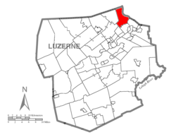 Map of Luzerne County, Pennsylvania Highlighting Exeter Township | |
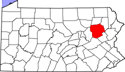 Map of Luzerne County, Pennsylvania | |
| Country | United States |
| State | Pennsylvania |
| County | Luzerne |
| Region | Greater Pittston |
| Government | |
| • Type | Second Class Township |
| • Chairman | Donald Hoffman |
| Area | |
| • Total | 13.5 sq mi (34.9 km2) |
| • Land | 13.0 sq mi (33.7 km2) |
| • Water | 0.5 sq mi (1.2 km2) |
| Population (2010) | |
| • Total | 2,378 |
| • Density | 180/sq mi (68/km2) |
| Time zone | Eastern (EST) (UTC-5) |
| • Summer (DST) | EDT (UTC-4) |
| Area code(s) | 570 |

Exeter Township is a township within the Greater Pittston area of Luzerne County, Pennsylvania, United States. The population was 2,378 at the 2010 census.[1]
Geography
According to the United States Census Bureau, the township has a total area of 13.5 square miles (34.9 km2), of which 13.0 square miles (33.7 km2) is land and 0.46 square miles (1.2 km2), or 3.56%, is water. Pennsylvania Route 92 is the main road in Exeter Township, which is roughly the trail of Sullivan's March.
History
The name Exeter derives from the town of Exeter in Devon, England. Numerous other places have also been given the name Exeter.
Demographics
As of the census[2] of 2000, there were 2,557 people, 943 households, and 729 families residing in the township. The population density was 198.5 people per square mile (76.7/km2). There were 1,038 housing units at an average density of 80.6/sq mi (31.1/km2). The racial makeup of the township was 99.30% White, 0.08% African American, 0.04% Native American, 0.08% Asian, 0.16% Pacific Islander, 0.31% from other races, and 0.04% from two or more races. Hispanic or Latino of any race were 0.35% of the population.
There were 943 households, out of which 34.8% had children under the age of 18 living with them, 67.0% were married couples living together, 6.7% had a female householder with no husband present, and 22.6% were non-families. 18.2% of all households were made up of individuals, and 7.5% had someone living alone who was 65 years of age or older. The average household size was 2.71 and the average family size was 3.10.
In the township the population was spread out, with 24.3% under the age of 18, 5.9% from 18 to 24, 32.0% from 25 to 44, 26.8% from 45 to 64, and 11.0% who were 65 years of age or older. The median age was 38 years. For every 100 females there were 101.0 males. For every 100 females age 18 and over, there were 101.0 males.
The median income for a household in the township was $43,600, and the median income for a family was $49,722. Males had a median income of $33,547 versus $25,428 for females. The per capita income for the township was $18,134. About 4.5% of families and 6.1% of the population were below the poverty line, including 7.0% of those under age 18 and 12.7% of those age 65 or over.
References
- ↑ "Profile of General Population and Housing Characteristics: 2010 Demographic Profile Data (DP-1): Exeter township, Luzerne County, Pennsylvania". U.S. Census Bureau, American Factfinder. Retrieved April 16, 2012.
- ↑ "American FactFinder". United States Census Bureau. Retrieved 2008-01-31.
Municipalities and communities of Luzerne County, Pennsylvania, United States | ||
|---|---|---|
| Cities | | |
| Boroughs |
| |
| Townships | ||
| CDPs | ||
| Unincorporated communities |
| |
| Footnotes | ‡This populated place also has portions in an adjacent county or counties | |
Coordinates: 41°22′00″N 75°49′59″W / 41.36667°N 75.83306°W