Harveys Lake, Pennsylvania
| Harveys Lake, Pennsylvania | |
|---|---|
| Borough | |
|
Harveys Lake from the northeast | |
 Harveys Lake | |
| Coordinates: 41°21′48″N 76°02′38″W / 41.36333°N 76.04389°WCoordinates: 41°21′48″N 76°02′38″W / 41.36333°N 76.04389°W | |
| Country | United States |
| State | Pennsylvania |
| County | Luzerne |
| Settled | 1781 |
| Incorporated | 1968[1] |
| Government | |
| • Type | Borough Council |
| Area | |
| • Total | 6.2 sq mi (16.0 km2) |
| • Land | 5.2 sq mi (13.4 km2) |
| • Water | 1.0 sq mi (2.6 km2) |
| Population (2010) | |
| • Total | 2,791 |
| • Density | 450/sq mi (170/km2) |
| Time zone | Eastern (EST) (UTC-5) |
| • Summer (DST) | EDT (UTC-4) |
| ZIP code | 18618 |
| Area code(s) | 570 |
| Website | http://harveyslakepa.us/ |
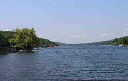
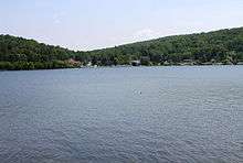
Harveys Lake is a borough in Luzerne County, Pennsylvania, United States. The lake within the borough is the largest natural lake by volume contained entirely in Pennsylvania. The lake was named after Benjamin Harvey, who founded the borough in 1781 and was a member of the Sons of Liberty, an eminent colonial-era group that eventually defeated the notion of Great Britain's Stamp Act. The borough population was 2,791 at the 2010 census.[2]
Geography
Harveys Lake is located at 41°21′48″N 76°2′38″W / 41.36333°N 76.04389°W (41.363335, -76.043989).[3]
According to the United States Census Bureau, the borough has a total area of 6.2 square miles (16.0 km2), of which 5.2 square miles (13.4 km2) is land and 1.0 square mile (2.6 km2), or 16.45%, is water.[4] The lake has a maximum depth of 104 feet (32 m).
Harveys Lake is the largest natural lake in Pennsylvania by volume. The largest by surface area is Conneaut Lake, in western Pennsylvania. The surface area of Harveys Lake is 658 acres (266 ha), compared to 947 acres (383 ha) for Conneaut Lake.
Demographics
| Historical population | |||
|---|---|---|---|
| Census | Pop. | %± | |
| 1970 | 1,693 | — | |
| 1980 | 2,318 | 36.9% | |
| 1990 | 2,746 | 18.5% | |
| 2000 | 2,888 | 5.2% | |
| 2010 | 2,791 | −3.4% | |
| Est. 2015 | 2,768 | [5] | −0.8% |
| Sources:[6][7][8] | |||
As of the census[7] of 2000, there were 2,888 people, 1,185 households, and 791 families residing in the borough. The population density was 540.1 people per square mile (208.4/km2). There were 1,735 housing units at an average density of 324.5/sq mi (125.2/km2). The racial makeup of the borough was 98.10% White, 0.14% African American, 0.31% Native American, 0.38% Asian, 0.03% Pacific Islander, 0.31% from other races, and 0.73% from two or more races. Hispanic or Latino of any race were 0.76% of the population.
There were 1,185 households, out of which 29.6% had children under the age of 18 living with them, 53.8% were married couples living together, 8.7% had a female householder with no husband present, and 33.2% were non-families. 27.7% of all households were made up of individuals, and 8.6% had someone living alone who was 65 years of age or older. The average household size was 2.44 and the average family size was 2.97.
In the borough the population was spread out, with 22.8% under the age of 18, 7.3% from 18 to 24, 30.1% from 25 to 44, 26.8% from 45 to 64, and 13.0% who were 65 years of age or older. The median age was 39 years. For every 100 females there were 97.8 males. For every 100 females age 18 and over, there were 95.3 males.
The median income for a household in the borough was $37,656, and the median income for a family was $51,319. Males had a median income of $31,059 versus $25,528 for females. The per capita income for the borough was $22,795. About 3.0% of families and 6.7% of the population were below the poverty line, including 6.2% of those under age 18 and 6.9% of those age 65 or over.
References
- ↑ "History of Harveys Lake". Retrieved 10 January 2014.
- ↑ "Profile of General Population and Housing Characteristics: 2010 Demographic Profile Data (DP-1): Harveys Lake borough, Pennsylvania". U.S. Census Bureau, American Factfinder. Retrieved April 12, 2012.
- ↑ "US Gazetteer files: 2010, 2000, and 1990". United States Census Bureau. 2011-02-12. Retrieved 2011-04-23.
- ↑ "Geographic Identifiers: 2010 Demographic Profile Data (G001): Harveys Lake borough, Pennsylvania". U.S. Census Bureau, American Factfinder. Retrieved April 12, 2012.
- ↑ "Annual Estimates of the Resident Population for Incorporated Places: April 1, 2010 to July 1, 2015". Retrieved July 2, 2016.
- ↑ "Census of Population and Housing". U.S. Census Bureau. Retrieved 11 December 2013.
- 1 2 "American FactFinder". United States Census Bureau. Retrieved 2008-01-31.
- ↑ "Incorporated Places and Minor Civil Divisions Datasets: Subcounty Resident Population Estimates: April 1, 2010 to July 1, 2012". Population Estimates. U.S. Census Bureau. Retrieved 11 December 2013.
External links
 Media related to Harveys Lake at Wikimedia Commons
Municipalities and communities of Luzerne County, Pennsylvania, United States | ||
|---|---|---|
| Cities | 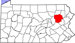 | |
| Boroughs |
| |
| Townships | ||
| CDPs | ||
| Unincorporated communities |
| |
| Footnotes | ‡This populated place also has portions in an adjacent county or counties | |