Wapwallopen, Pennsylvania
"Wapwallopen" redirects here. For other uses, see Wapwallopen (disambiguation).
| Wapwallopen, Pennsylvania | |
|---|---|
| Unincorporated community | |
|
View of Wapwallopen, Pennsylvania | |
 Wapwallopen, Pennsylvania Location within the state of Pennsylvania | |
| Coordinates: 41°07′50″N 76°13′10″W / 41.13056°N 76.21944°WCoordinates: 41°07′50″N 76°13′10″W / 41.13056°N 76.21944°W | |
| Country | United States |
| State | Pennsylvania |
| County | Luzerne |
| Elevation | 541 ft (165 m) |
| Time zone | Eastern (EST) |
| • Summer (DST) | EDT (UTC) |
| ZIP code | 18660 |
| Area code(s) | 570 |
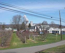
Wapwallopen is an unincorporated community in lower Luzerne County, Pennsylvania. It is designated a "populated community place" (class code U6), a populated place that is not a census designated or incorporated place having an official federally recognized name. It get its name from a Native American settlement that was established where Big Wapwallopen Creek feeds into the Susquehanna River. The Great Indian Warpath historically passed through the area.
External links
Municipalities and communities of Luzerne County, Pennsylvania, United States | ||
|---|---|---|
| Cities | 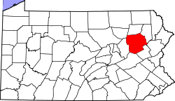 | |
| Boroughs |
| |
| Townships | ||
| CDPs | ||
| Unincorporated communities |
| |
| Footnotes | ‡This populated place also has portions in an adjacent county or counties | |
This article is issued from Wikipedia - version of the 11/21/2016. The text is available under the Creative Commons Attribution/Share Alike but additional terms may apply for the media files.