Interstate 476
| |||||||||||||
|---|---|---|---|---|---|---|---|---|---|---|---|---|---|
_map.png) | |||||||||||||
| Route information | |||||||||||||
| Auxiliary route of I-76 | |||||||||||||
| Maintained by PennDOT and PTC | |||||||||||||
| Length: | 132.10 mi[1][2][3] (212.59 km) | ||||||||||||
| History: |
Established 1964 Completed on December 16, 1992[2] | ||||||||||||
| Tourist routes: | Blue Route Scenic Byway | ||||||||||||
| Major junctions | |||||||||||||
| South end: |
| ||||||||||||
| |||||||||||||
| North end: |
| ||||||||||||
| Location | |||||||||||||
| Counties: | Delaware, Montgomery, Bucks, Lehigh, Carbon, Luzerne, Lackawanna | ||||||||||||
| Highway system | |||||||||||||
| |||||||||||||

Interstate 476 (I-476) is a 132.1-mile (212.59 km) auxiliary Interstate Highway in the U.S. state of Pennsylvania designated between Interstate 95 near Chester and Interstate 81 near Scranton, serving as the primary north–south Interstate corridor through eastern Pennsylvania. It consists of both the 20-mile (32.19 km) Mid-County Expressway, locally referred to as the "Blue Route" (although no signs exist with that designation), through the suburban Philadelphia-area counties of Delaware and Montgomery, and the 110.6-mile (177.99 km) Northeast Extension of the Pennsylvania Turnpike connecting the Philadelphia metropolitan area with the Lehigh Valley, the Poconos, and the Wyoming Valley. The Blue Route passes through suburban areas, while the Northeast Extension predominantly runs through rural areas of mountains and farmland, with development closer to Philadelphia and in the Lehigh Valley and the Wyoming Valley. I-476 intersects many major roads including Interstate 76 (the Schuylkill Expressway) in West Conshohocken, Interstate 276 (the Pennsylvania Turnpike) in Plymouth Meeting, U.S. Route 22 near Allentown, and Interstate 80 near Hickory Run State Park.
While proposed as early as 1929, the construction of the Mid-County Expressway did not begin until 1967 and was not completed until 1992 due to massive community and environmental opposition during the freeway revolts of the 1960s and 1970s, leading The Philadelphia Inquirer to dub it "the most costly, most bitterly opposed highway in Pennsylvania history." In order to get the route through Delaware County, it was built with many environmental compromises such as a parkway design and four lanes south of the Pennsylvania Route 3 interchange. The Mid-County Expressway received its "Blue Route" nickname from the chosen route through Delaware County on planning maps on which it was differentiated from the other proposed routes by its color.
Following the completion of the Mid-County Expressway, in 1996 the Interstate 476 designation was extended to include the entire length of the existing Northeast Extension, replacing PA 9. The Northeast Extension was built between 1955 and 1957 and was originally projected to continue past Clarks Summit to the New York border; however, I-81 was built between these two points instead. Since the extension, I-476 has been the longest auxiliary Interstate Highway in the United States (surpassing Interstate 495 in Massachusetts), but it may someday be surpassed in length by Interstate 369 in Texas. In fact, it is longer than some mainline interstates (such as Interstate 83 in Maryland and Pennsylvania, Interstate 99 in Pennsylvania, Interstate 12 in Louisiana, Interstate 19 in Arizona, Interstate 97 in Maryland, and Interstate 2 in Texas). Additionally, its numbering is unusual, since auxiliary interstates beginning in even numbers are typically bypasses or loops rather than spurs.
Route description
Blue Route
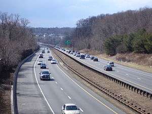
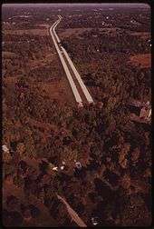
The portion of Interstate 476 between Interstate 95 and Interstate 276 runs north–south through Delaware and Montgomery Counties and is officially known as the Mid-County Expressway and the Veterans Memorial Highway, as well as by the nickname the "Blue Route". The road's southern terminus is at a junction with Interstate 95 near Chester, a city southwest of Philadelphia, near Philadelphia International Airport.[4] Heading north, the road immediately narrows to a four-lane parkway north of Exit 1, MacDade Boulevard. It winds through the western Philadelphia suburbs of Wallingford and Swarthmore, where I-476 comes to an interchange with Baltimore Pike. From here, the freeway continues north to Springfield, where it meets U.S. Route 1 at a three-level diamond interchange.[4]
Past US 1, I-476 continues through wooded suburban areas and interchanges with Pennsylvania Route 3 in Broomall, where it widens to six lanes.[4] The route continues to Radnor Township, on the Main Line, where it interchanges with U.S. Route 30.[4] Stone monuments, including a large stone cairn atop a hill and a large crushed-stone image of a mythological griffin on a hillside, were constructed at the Route 30 interchange to commemorate Radnor's history as part of the Welsh Tract.[5] Proceeding northward, the route enters Montgomery County and comes to an interchange with Interstate 76 (Schuylkill Expressway) at West Conshohocken. After crossing the Schuylkill River on the Pearl Harbor Memorial Bridge, the freeway heads into Plymouth Township, where it interchanges with Ridge Pike and Germantown Pike before coming to the Mid-County Interchange with the Pennsylvania Turnpike in Plymouth Meeting.[4][6] The entire length of the Blue Route is designated the Blue Route Scenic Byway, a Pennsylvania Scenic Byway.[7]
Northeast Extension
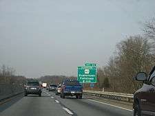
Beyond the Mid-County Interchange, Interstate 476 enters the Pennsylvania Turnpike system, interchanging with Interstate 276 and continuing north as the Northeast Extension of the Pennsylvania Turnpike. The route continues through the Philadelphia suburbs interchanging with Pennsylvania Route 63 near Lansdale. Past this interchange, the route enters a more rural setting of woods and farms, crossing into Bucks County and coming to an interchange with Pennsylvania Route 663 near Quakertown. The Northeast Extension continues into Lehigh County, part of the Lehigh Valley metropolitan area, past the PA 663 interchange. Here, it interchanges with U.S. 22 (Lehigh Valley Thruway) near Allentown, which offers an indirect connection to Pennsylvania Route 309 and Interstate 78.[4]
North of Allentown, the route runs through more farmland before passing under the Blue Mountain in the Lehigh Tunnel and entering Carbon County in the Poconos. Here, I-476 crosses over the Lehigh River and interchanges with U.S. 209 near Lehighton. Continuing through mountainous areas, it has an E-ZPass-only exit for Pennsylvania Route 903 and cuts through Hickory Run State Park before interchanging with Interstate 80 and Pennsylvania Route 940 just to the north of the state park.[4] The route continues through mountainous terrain, heading into Luzerne County and coming to an interchange with Pennsylvania Route 115 in Bear Creek that provides access to nearby Wilkes-Barre.[4] The route comes to a toll barrier near Pittston that marks the northern end of the toll ticket system in the Northeast Extension.[4][8] A short distance later, an interchange with Pennsylvania Route 315 provides indirect access to Interstate 81 and Scranton. Past this interchange, I-476 enters Lackawanna County and crosses built-up areas of the Wyoming Valley as it skirts around Scranton, with a mainline toll plaza and an exit to Keyser Avenue. North of Scranton in Clarks Summit, the route comes to a hairpin curve and ends at an interchange with connections to Interstate 81, U.S. Route 6 and U.S. Route 11. US 6 joins the turnpike for less than a quarter mile to connect between I-81 and US 11. As this is north of the Clarks Summit toll plaza, no toll is collected on this short segment.[6]
Tolls
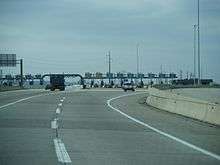
The Northeast Extension of the Pennsylvania Turnpike uses the ticket system method of tolling between the Mid-County and Wyoming Valley toll plazas along with the mainline Pennsylvania Turnpike.[9] With the ticket system, a motorist receives a ticket upon entering the turnpike at an interchange and pays the fare and surrenders the ticket upon exiting. If a motorist loses the ticket, the turnpike charges the highest fare to the exit where the motorist leaves.[10] Mainline toll plazas are also located at Keyser Avenue and Clarks Summit, charging a flat rate. There are no tolls on exit ramps between Wyoming Valley and Clarks Summit. E-ZPass is accepted at all toll plazas. As of 2016, it costs a passenger vehicle $11.40 to travel the length of the Northeast Extension between Mid-County and Wyoming Valley using cash and $8.06 using E-ZPass. The Keyser Avenue and Clarks Summit toll plazas cost $1.35 using cash and $0.76 using E-ZPass for passenger vehicles.[9]
The tickets along the Northeast Extension of the Pennsylvania Turnpike were originally handed out by person. In 1987, machines started to replace humans in distributing tickets.[11] In 1990, an electronic toll collection system was proposed for the Pennsylvania Turnpike, where a motorist would create an account and use an electronic device that would be read from an electronic tollbooth. The motorist would be billed later.[12] The multi-state electronic tolling system, which was to be called E-ZPass, was planned to be implemented by 1998.[13][14] The planned installation date was later pushed back to 2000.[15] On December 2, 2000, E-ZPass debuted along the Northeast Extension of the Pennsylvania Turnpike between Mid-County and Lehigh Valley.[16][17] On December 15, 2001, E-ZPass was extended to include the entire length of the Northeast Extension of the Pennsylvania Turnpike.[18][19] Commercial vehicles were allowed to start using E-ZPass on December 14, 2002.[20]
On November 24, 2004, the day before Thanksgiving, 2,000 Teamsters Union employees went on strike, after contract negotiations failed. This was the first strike in the history of the roadway. As this is usually one of the busiest traffic days in the United States, to avoid traffic jams, tolls were waived for the rest of the day.[21] Starting on November 25, turnpike management personnel collected flat-rate passenger tolls of $2 and commercial tolls of $15 from cash customers on the ticketed system, while E-ZPass customers were charged the lesser of the actual toll or the same flat rates.[22] The strike ended after seven days when both sides reached an agreement on November 30. Normal toll collection resumed December 1.[23]
The Turnpike Commission announced plans to consider eliminating manned toll booths in favor of all-electronic tolls. With this, tolls will be paid using either E-ZPass or credit cards.[24] Drivers unable to pay by either of these methods will be billed in the mail using license plate recognition; an additional surcharge will be applied.[25] In addition to E-ZPass, the turnpike commission offered other automated options to pay for tolls such as using a prepaid account that utilizes license plate recognition. McCormick Taylor and Wilbur Smith Associates have been hired to conduct a feasibility study on converting the road to all-electronic tolls.[26]
On March 6, 2012, the turnpike commission announced that it was going forward with an all-electronic tolling plan.[27] Such a plan will take at least five years to implement to allow time for equipment to be installed and the reconfiguration of ramps. It will save the turnpike commission $65 million a year on labor costs by eliminating toll collectors. The plans call for a 76% surcharge for motorists who do not have E-ZPass that are billed by mail. This surcharge could raise the toll for someone without E-ZPass to $53.10 to travel the entire turnpike.[28] In October 2016, the turnpike began accepting credit cards as payment at all cash toll booths.[29]
Services
Emergency assistance and information
The Northeast Extension has a callbox every mile for its entire length.[30] Motorists may also dial *11 on their mobile phones. First responder services are available to all turnpike customers via the State Farm Safety Patrol program. The safety patrol program, which is free, looks for disabled motorists, debris, and accidents along the roadway and provides assistance. The patrol service is available 24 hours every day of the year. Each patrol vehicle covers a 20-to-25-mile (32 to 40 km) stretch of the turnpike.[30] Towing services are available from authorized service garages located near the highway.[31] Pennsylvania State Police Troop T patrols the Pennsylvania Turnpike Northeast Extension. It has headquarters in Highspire and a substation at Pocono.[32]
The Pennsylvania Turnpike Commission broadcasts current roadway, traffic, and weather conditions via "Highway Advisory Radio" transmitters at each exit. Broadcasts are available on AM 1640 and can be received approximately two miles away from each exit.[33] Motorists can also receive alerts and information via the internet, mobile phone, a hotline, and message boards at service plazas through the Turnpike Roadway Information Program (TRIP).[34]
Service plazas
The Northeast Extension of the Pennsylvania Turnpike has 2 service plazas. The service plazas offer various fast food restaurants such as Burger King, Roy Rogers, Famous Famiglia Pizzeria, Auntie Anne's, Hershey's Ice Cream, and Starbucks, and a gift shop. Each service plaza also has a Sunoco gas station and an A-Plus convenience store. Other amenities are available such as an ATM, pay phone, picnic areas, restrooms, tourist information, and Wi-Fi. The Allentown plaza contains a seasonal farmers market.[35]
In 2006, HMSHost was awarded a contract to reconstruct the service plazas along the turnpike.[36] The reconstruction of the service plazas, which is to cost $150 million, will include a food court layout and modernized restrooms. Sunoco will continue to operate the gas stations at the renovated service plazas. The Allentown service plaza was rebuilt between September 2007 and May 2008 while the Hickory Run service plaza was rebuilt between January 2009 and November 2010.[37]
History
Mid-County Expressway
Originally planned as far back as 1929, the Mid-County Expressway was later proposed by the Pennsylvania Turnpike Commission as the "Chester Extension" of the Pennsylvania Turnpike in 1954. After the advent of the Interstate Highway System, the project was transferred to the Pennsylvania Department of Highways to be built as part of the system, designating it first as Interstate 495, and later as Interstate 480, as I-76 was designated as I-80S at the time. The present-day I-476 designation was assigned on February 6, 1964 when I-80S was renumbered as I-76.[38]
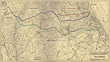
The road received its nickname from a 1958 location report indicating various proposed geographic configurations of an expressway through Delaware County with lines of various colors on a map. The "blue route" through the Crum Creek valley won out over other contenders, which included a more easterly "red route" and "yellow route" and a more westerly "green route".[39]
As one of the most controversial Interstate Highways in Pennsylvania, construction of I-476 began in 1967, but was not completed until 1991 between MacDade Boulevard (Exit 1) and Interstate 76 (Exit 16), and until 1992 between Germantown Pike east/Chemical Road (Exit 19) and Interstate 276/Pennsylvania Turnpike (Exit 20), due to litigation between the Pennsylvania Department of Transportation and several communities in the road's path over environmental concerns. However, the section of Interstate 476 (south end of I-476) between I-95 and MacDade Blvd. (Exit 1) was opened in 1987, but signage labeled it as a route "To MacDade Blvd" until 1991 when I-476/The Blue Route was opened between Exits 1 and 16, and connected with the short existing section of roadway dating back to 1979 from Exit 16-Exit 19.
An agreement in 1985 led to many environmental compromises in the road's design, including a downsized four-lane design south of Pennsylvania Route 3, ramp meters, and federal scenic route status, prohibiting the erection of advertisement billboards along the entire freeway portion. While the redesigned highway was largely well-received, the constriction to four lanes has led to bottleneck conditions in the area, and many communities that originally opposed the road have now called for its widening.[40] The Philadelphia Inquirer dubbed I-476 "the most costly, most bitterly opposed highway in Pennsylvania history" due to the decades of opposition it garnered.[41]
In the 2000s, the road underwent a complete rehabilitation project, including paving, bridge repair, and ramp maintenance of the entire length of the freeway between Interstate 95 and the Pennsylvania Turnpike.[42] The section between I-95 and I-76 was completed in 2007 and the section between I-76 and I-276 was completed in the end of 2011.
Northeast Extension history
| |
|---|---|
| Location: | Plymouth Meeting – Clarks Summit |
| Length: | 111.04 mi[43] (178.70 km) |
| Existed: | 1980–1996 |
In 1953, an extension of the Pennsylvania Turnpike from the mainline near Philadelphia north through Northeastern Pennsylvania to the New York border near Binghamton was proposed.[44][45] Groundbreaking for the Northeastern Extension occurred on March 25, 1954 in White Haven, with Governor John S. Fine and commission chairman Thomas J. Evans present. The Northeast Extension was planned to run from the mainline Pennsylvania Turnpike in Plymouth Meeting north to a temporary terminus at Scranton.[46] In April 1954, $233 million in bonds were issued to build the Northeastern Extension along with the Delaware River Bridge on the mainline Pennsylvania Turnpike.[47] The Northeast Extension was built with a 4-foot (1.2 m) median in order to save money.[48] Due to the mountainous terrain it passed through, a large amount of earthwork was necessary to build the road along with the construction of large bridges.[49] Among the bridges built was the 1,632-foot-long (497 m) Clark's Summit Bridge over US 6/US 11, which was the tallest bridge on the Pennsylvania Turnpike system at 135 feet (41 m).[50] The Northeast Extension also included the two-lane Lehigh Tunnel through Blue Mountain. The tunnel was originally going to be named for commission chairman Evans, but was changed when he was convicted of conspiracy to defraud the commission of $19 million (equal to $135,066,866 today).[49]
The roadway opened between Plymouth Meeting and the Lehigh Valley interchange near Allentown on November 23, 1955. The highway was extended north to Emerald on December 28, 1955.[51] The Northeast Extension was opened between Emerald and Wyoming Valley on April 1, 1957.[52] The entire length of the Northeast Extension was finished on November 7, 1957 with the completion of the northernmost part between Wyoming Valley and Scranton.[53] The part of the Northeast Extension between Scranton and the New York border would not be built as part of the Pennsylvania Turnpike system but rather the Interstate Highway System as I-81.[54][55] At the northern terminus, the Northeast Extension narrowed to two lanes along the northbound off-ramp at Scranton to come to its northern terminus, with an abandoned short spur of the mainline heading north. A pair of trumpet interchanges were built to connect the Northeast Extension and I-81.[55] In 1980, the roadway would be designated PA 9.[56]
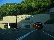
When it first opened, traffic on the Northeast Extension of the Pennsylvania Turnpike was light.[48] By the 1970s, traffic along the roadway would increase with the completion of the connecting I-80 and the rising popularity of the Poconos as a vacation destination. As a result, the two-lane Lehigh Tunnel faced serious congestion. Plans were made to either bypass the tunnel or add a second tube. The turnpike commission decided it would build a second tunnel as the cost was lower than building a bypass.[57] In 1988, a $37 million contract was awarded to build the second tube.[58] Groundbreaking for the tunnel took place on February 14, 1989, with Governor Robert P. Casey in attendance.[59] Excavation of the new tunnel began in July of that year. Construction of the second tube utilized the New Austrian Tunnelling method, which reduced the cost of the tunnel by $5 to $6 million. It was the first tunnel in the United States to use this construction method. The second tube at Lehigh Tunnel opened on November 22, 1991, with Governor Casey in attendance leading a line of antique cars. Construction of the tunnel cost $45 million. The new tube is used for southbound traffic while the original tube carries northbound traffic. The newer tunnel is wider, higher, and brighter than the original.[60]
On February 1, 1995, the Keyser Avenue interchange near Scranton was slated to open at a cost of $22.4 million. Construction of this interchange also involved constructing a new mainline flat-rate toll barrier near the new interchange.[61]
On November 1, 1996, the Northeast Extension was added to the Interstate Highway System as an extension of I-476, replacing the PA 9 designation along the road. The addition of the second tube at the Lehigh Tunnel along with new guardrails and line striping was necessary for the toll road to become an Interstate. It was hoped that the Interstate designation would bring economic development and tourism to the areas served by the roadway.[62] This extension resulted in I-476 surpassing the 120-mile (190 km) I-495 in Massachusetts as the longest auxiliary Interstate Highway.[63]
In 2007, the turnpike commission announced plans to widen the Northeast Extension to six lanes between Mid-County and Lansdale.[64] In January 2008, work began on the replacement of two bridges over the Northeast Extension to accommodate the widened highway. The widening was originally expected to be complete in 2013; however, construction fell a year behind schedule.[65][66] Construction on the southern section of the widening project between Mid-County and Lansdale began in January 2011 was finished in October 2014 while work on the northern portion started in May 2014 and will be finished by the end of 2016.[67] Following the completion of widening this section, the portion of the roadway from Lansdale to Quakertown will be widened to six lanes.[65] In spring 2013, replacement of bridges began between mileposts 31 and 38, with work on the actual widening to begin in fall 2016.[68]
In 1990, plans were made to build an interchange at PA 903 in Carbon County. A bill authorizing construction of this interchange was signed into law by Governor Casey in July of that year.[69] Plans for this interchange were cancelled by the turnpike commission in 1995.[70] In 2006, plans for an interchange at PA 903 were resurrected, with the proposed interchange to be all-electronic, in that it will only accept E-ZPass.[71] Construction on the $23 million interchange began in the middle of 2008.[72][73] The interchange opened to traffic on June 30, 2015.[74]
On April 28, 2016, plans were announced for a "Scranton Beltway" to use I-476 as a bypass for I-81 around the heavily congested segment through Scranton and its suburbs. The turnpike between the two I-81 interchanges carries an average of 10,000 vehicles per day vs. 70,000 on the parallel segment of I-81. This project will build two high-speed connections between I-476 and I-81: one south of Scranton in Dupont and one north of Scranton in South Abington Township. Tolls on the connections will be paid with E-ZPass or toll-by-plate. Construction on this project, which is expected to cost $160 million, could begin as soon as 2021.[75]
Exit list
The old exit numbers (31 and upward) on the turnpike Northeast Extension were a continuation of old exit numbers 1 through 30 on the east-west turnpike. On the east-west turnpike, the interchange with I-476 was old exit 25A because it was between old exits 25 and 26 on the east–west turnpike.
| County | Location | mi[43] | km | Old exit [76] | New exit [76] | Name | Destinations | Notes |
|---|---|---|---|---|---|---|---|---|
| Delaware | Ridley Township | 0.00 | 0.00 | – | – | Exit 7 on I-95 | ||
| 0.48 | 0.77 | 1 | 1 | MacDade Boulevard | Serves Ridley and Chester | |||
| Nether Providence Township | 3.39 | 5.46 | 2 | 3 | Media, Swarthmore | Access via Baltimore Pike | ||
| Marple Township | 5.07 | 8.16 | 3 | 5 | ||||
| 8.77 | 14.11 | 4 | 9 | To Havertown and Newtown Square | ||||
| Radnor Township | 13.24 | 21.31 | 5 | 13 | Serves Philadelphia Main Line | |||
| Montgomery | West Conshohocken | 15.84 | 25.49 | 6 | 16 | Signed as exits 16A (east) and 16B (west) northbound; exit 331 on I-76 | ||
| Plymouth Township | 18.81 | 30.27 | 7A | 18A | Conshohocken | Northbound exit and southbound entrance; access via Ridge Pike | ||
| 7B | 18B | Norristown | Via Chemical Road; signed as exit 18 southbound | |||||
| 19.69 | 31.69 | 8 | 19 | Germantown Pike east – Plymouth Meeting | Northbound exit and southbound entrance | |||
| 19.97 | 32.14 | 9 | 20 | Southbound exit is via I-276 / Penna Turnpike; via Germantown Pike west | ||||
| Mid-County Toll Plaza Blue Route transitions to Pennsylvania Turnpike Northeast Extension | ||||||||
| 20.33 | 32.72 | 25A | 20 | Mid-County | Northbound exit to I-276 west is via exit 20 | |||
| Towamencin Township | 30.78 | 49.54 | 31 | 31 | Lansdale | |||
| Bucks | Milford Township | 44.39 | 71.44 | 32 | 44 | Quakertown | ||
| Lehigh | Upper Macungie Township | 56.37 | 90.72 | Allentown Service Plaza | ||||
| South Whitehall Township | 57.71 | 92.88 | 33 | 56 | Lehigh Valley | |||
| Blue Mountain | 71.68 | 115.36 | Lehigh Tunnel | |||||
| Carbon | Franklin Township | 75.73 | 121.88 | 34 | 74 | Mahoning Valley | Serves The Poconos | |
| Penn Forest Township | 86.62 | 139.40 | Hickory Run Service Plaza | |||||
| 87.39 | 140.64 | – | 87 | SR 903 | E-ZPass-only interchange | |||
| Kidder Township | 94.82 | 152.60 | 35 | 95 | Pocono | |||
| Luzerne | Bear Creek Township | 105.85 | 170.35 | 36 | 105 | Wilkes-Barre | ||
| Pittston Township | 113.42 | 182.53 | Wyoming Valley Toll Plaza North end of ticket system | |||||
| 115.17 | 185.35 | 37 | 115 | Wyoming Valley | ||||
| Lackawanna | Taylor | 121.61 | 195.71 | Keyser Avenue Mainline Toll Plaza Cash or E-ZPass | ||||
| 122.36 | 196.92 | 38 | 122 | Keyser Avenue | Old Forge, Taylor | Access via Keyser Avenue | ||
| Clarks Summit | 131.20 | 211.15 | Clarks Summit Mainline Toll Plaza Cash or E-ZPass | |||||
| 131.37 | 211.42 | 39 | 131 | Clarks Summit | Exit 194 on I-81 | |||
1.000 mi = 1.609 km; 1.000 km = 0.621 mi
| ||||||||
See also
 U.S. Roads portal
 Pennsylvania portal
References
- ↑ "Resurfacing" (PDF). I-476 Improvement Project. Pennsylvania Department of Transportation. Retrieved 2007-03-07.
- 1 2 Jeremy Rogoff; Mari A. Schaefer (2007-06-10). "No remedy soon for a clogged Blue Route". The Philadelphia Inquirer. p. 2.
- ↑ "Pennsylvania Turnpike Toll/Mileage Calculator". Pennsylvania Turnpike Commission. Retrieved 2007-03-07.
- 1 2 3 4 5 6 7 8 9 Google (2009-06-01). "overview of Interstate 476" (Map). Google Maps. Google. Retrieved 2009-06-01.
- ↑ Radnor Township website, Gateway Enhancement Strategy
- 1 2 Official Tourism and Transportation (PDF) (Map). Pennsylvania Department of Transportation. 2015. Retrieved February 2, 2016.
- ↑ "Blue Route". VisitPA.com. Retrieved March 27, 2012.
- ↑ "Toll Schedule – Cash Rates" (PDF). Pennsylvania Turnpike Commission. January 4, 2009. Retrieved 2009-06-01.
- 1 2 2016 Toll Schedule (PDF). Pennsylvania Turnpike Commission. 2016. Retrieved January 3, 2016.
- ↑ "Traffic Rules and Regulations". Pennsylvania Turnpike Commission. Retrieved August 3, 2015.
- ↑ Blankenship, Karl (July 22, 1987). "That's the ticket: Machines replacing man on turnpike". The Patriot-News. Harrisburg, PA. p. B1.
- ↑ "Drive Now, Pay The Toll Later Pike Travelers Favor The Electronic System". Philadelphia Daily News. July 12, 1990. p. 28.
- ↑ "Electronic tolls coming to Pa. Turnpike by 1998". Lancaster New Era. Associated Press. March 22, 1994. p. A03.
- ↑ Gilbert, Pat R. (March 22, 1994). "7 Agencies OK Electronic Toll-Collection Firm - Project Expected To Speed Traffic On Parkway, Turnpike". The Record. Bergen County, NJ. p. A03.
- ↑ Wyckoff, P.L. (March 12, 1998). "E-ZPass to debut on Atlantic City highway - But 2000 is target for Turnpike and Parkway". The Star-Ledger. Newark, NJ. p. 22.
- ↑ Downs, Jere (December 3, 2000). "E-ZPass Off To UnE-Z Beginning On Turnpike". The Philadelphia Inquirer. p. B04.
- ↑ "E-ZPass not so easy for drivers on first day". Erie Times-News. Associated Press. December 3, 2000.
- ↑ "Pennsylvania Turnpike extends E-ZPass service". The Express-Times. Easton, PA. December 15, 2001.
- ↑ Fuoco, Michael A. (December 22, 2001). "Turnpike E-ZPass Will Get More Lanes". Pittsburgh Post-Gazette. p. D-6.
- ↑ Therolf, Garrett (December 15, 2002). "E-ZPass making life harder for bridge users". The Morning Call. Allentown, PA. p. B1.
- ↑ Wartenberg, Steve (November 25, 2004). "Turnpike strike lops tolls for a day ** 2,000 Teamsters take action. Non-union staff will be in booths today.". The Morning Call. Allentown, PA. p. A1.
- ↑ Shields, Jeff (November 26, 2004). "Traffic moves, despite strike - Turnpike managers working the toll booths gave drivers a pass when backups occurred. Negotiations were on hold.". The Philadelphia Inquirer. p. B01.
- ↑ "Turnpike returns tolls to normal - Drivers were issued tickets beginning at 9 p.m. Wednesday.". The Express-Times. Easton, PA. December 2, 2004. p. B1.
- ↑ Schmitz, Jon (October 6, 2010). "Turnpike considers all-electronic tolls". Pittsburgh Post-Gazette. Retrieved October 7, 2010.
- ↑ "No E-ZPass? Expect to pay extra to drive Interstate 76". Reading Eagle. October 11, 2010. Retrieved October 12, 2010.
- ↑ Mattar, George (December 29, 2010). "Turnpike considers getting rid of cash tolls". The Intelligencer. Doylestown, PA. p. 1.
- ↑ Thompson, Charles (March 6, 2012). "Caution: All-E-Z Pass turnpike ahead". The Patriot-News. Harrisburg, PA. p. A01.
- ↑ Nussbaum, Paul (March 13, 2012). "Pa. Turnpike looks at much higher non-E-ZPass rates". The Philadelphia Inquirer. p. A01.
- ↑ Abrams, Mark (October 13, 2016). "PA Turnpike Now Accepts Credit Cards As Payment Option". Philadelphia, PA: KYW-TV. Retrieved October 13, 2016.
- 1 2 "State Farm Safety Patrol Program". Pennsylvania Turnpike Commission. Retrieved August 3, 2015.
- ↑ "If Your Vehicle Breaks Down...". Pennsylvania Turnpike Commission. Retrieved August 3, 2015.
- ↑ "Pennsylvania State Police Troop T -Highspire". Pennsylvania State Police. Retrieved September 22, 2012.
- ↑ "HAR Transmissions Now Broadcast at Every PA Turnpike Interchange". Pennsylvania Turnpike Commission. July 3, 2000. Archived from the original on August 19, 2003. Retrieved April 14, 2009.
- ↑ "Turnpike Roadway Information Program" (PDF). Pennsylvania Turnpike Commission. Retrieved August 3, 2015.
- ↑ The Travelers Guide to PA Turnpike service plazas (PDF). Pennsylvania Turnpike Commission. 2015. Retrieved August 3, 2015.
- ↑ "Pennsylvania Turnpike Contract Awarded to HMSHost". Business Wire. July 28, 2006.
- ↑ "Service Plazas: Tentative Reconstruction Schedule". Pennsylvania Turnpike Commission. Archived from the original on August 29, 2015. Retrieved August 29, 2015.
- ↑ "Was I-76 Numbered to Honor Philadelphia for Independence Day, 1776?". Ask the Rambler. Federal Highway Administration. 2005-01-18. Retrieved 2007-06-06.
- ↑ "History of the Blue Route". I-476 Improvement Project. Pennsylvania Department of Transportation. Archived from the original on February 19, 2007. Retrieved 2007-06-11.
- ↑ "Asphalt: the Magazine of the Asphalt Institute, Summer 1997" (PDF). Retrieved 2007-03-07.
- ↑ "FHWA By Day - December 19". Retrieved 2007-03-07.
- ↑ "I-476 Improvement Project". Retrieved 2007-03-07.
- 1 2 DeLorme Street Atlas USA 2007, Toggle Measure Tool. Retrieved on 2007-02-27.
- ↑ "Tax-Exempts: Pennsylvania Turnpike Board Plans 125-Mile North-South Extension". The Wall Street Journal. August 5, 1953. p. 11.
- ↑ "Surveys To Expand Pennsylvania Pike". The New York Times. August 9, 1953. p. 56.
- ↑ "Turnpike Link Begins". The New York Times. March 26, 1954. p. 28.
- ↑ "Pike Funds Raised By Pennsylvania". The New York Times. April 8, 1954. p. 41.
- 1 2 Dakelman and Schorr, p. 105.
- 1 2 Dakelman, p. 106.
- ↑ Dakelman and Schorr, p. 107.
- ↑ Cupper, p. 31.
- ↑ "Pennsylvania Pike Spur To Scranton Area Opens". The New York Times. April 2, 1957. p. 26.
- ↑ "Pennsylvania Turnpike Opens Its Final Section". The New York Times. November 8, 1957. p. 21.
- ↑ "Turnpike To The Poconos". The New York Times. November 10, 1957. p. 163.
- 1 2 Dakelman and Schorr, p. 108.
- ↑ Pennsylvania Official Transportation Map (PDF) (Map). Pennsylvania Department of Transportation. 1980. Retrieved January 29, 2015.
- ↑ Cupper, p. 40.
- ↑ Cupper, p. 46.
- ↑ Orenstein, Robert H. (February 15, 1989). "Tunnel Project Blasts Off Governor Marks Start Of Construction". The Morning Call. Allentown, PA. p. B03.
- ↑ Laylo, Bob (November 23, 1991). "New Lehigh Tunnel Opens On Turnpike". The Morning Call. Allentown, PA. p. A03.
- ↑ "Turnpike Soon To Get New Lackawanna Exit". The Morning Call. Allentown, PA. January 25, 1995. p. B06.
- ↑ "PA Turnpike's Northeast Extension Now An Interstate". Erie Times-News. Associated Press. November 18, 1996.
- ↑ "Route Log and Finder List, table 2". Federal Highway Administration. 2002-10-31. Retrieved 2007-03-07.
- ↑ Wilen, John (March 30, 2007). "Turnpike to widen Northeast Extension - The Turnpike Commission has already notified more than 100 homeowners it wants to buy some or all of their property. Homeowners between Lansdale and Quakertown: You're next.". The Intelligencer. Doylestown, PA. p. A03.
- 1 2 Yates, Riley (January 7, 2008). "Bridge work could slow highway traffic.". The Intelligencer. Doylestown, PA. p. 1.
- ↑ Nussbaum, Paul (December 15, 2012). "Northeast Extension project a year behind schedule. But why?". The Philadelphia Inquirer. p. A01.
- ↑ "Current Project Overview and Schedule - Milepost A20-A31 Total Reconstruction Project". Pennsylvania Turnpike Commission. Retrieved April 30, 2016.
- ↑ "Northeastern Extension, Milepost A31 - A38 - Project Schedule". Pennsylvania Turnpike Commission. Retrieved April 30, 2016.
- ↑ "Harrisburg News: Casey Signs Interchange Bill". The Morning Call. Allentown, PA. July 13, 1990. p. B03.
- ↑ Braden, Tyra (August 24, 1995). "Carbon Turnpike Project Canceled - Commission Scraps Penn Forest Interchange Talks, Irks Legislator". The Morning Call. Allentown, PA. p. B03.
- ↑ Parker, Chris (April 28, 2006). "E-ZPass slip ramps on Turnpike in Pocono area garners support ** Plan would build them off Northeast Extension in Carbon.". The Morning Call. Allentown, PA. p. B5.
- ↑ Hartzell, Dan (October 11, 2010). "Long road ahead to Poconos access from Turnpike". The Morning Call. Allentown, PA. p. A5.
- ↑ "Constructing a New EZ Pass Only Interchange Exit #87 on the NE Extension at Route 903". Pennsylvania Turnpike Commission. Retrieved January 9, 2015.
- ↑ Michlowski, Bill (June 30, 2015). "New Turnpike Interchange Opens in Carbon County". Scranton, PA: WNEP-TV. Retrieved June 30, 2015.
- ↑ "Pennsylvania Turnpike and PennDOT Announce Next Step for Planned I-81-Turnpike Beltway for Scranton Region - Plan to Address Congestion Relief" (Press release). Pennsylvania Turnpike Commission. April 28, 2016. Retrieved April 30, 2016.
- 1 2 "Pennsylvania Exit Numbering" (PDF). Pennsylvania Department of Transportation. Retrieved 2007-10-02.
External links
| Wikimedia Commons has media related to Interstate 476. |
| ||
| ||
| Completed highways | ||
|---|---|---|
| Partially-completed highways | ||
| Tunnels and bridges | ||
| Aborted expansion plans | ||
| Historical structures | ||
| Tolling systems | ||