Penns Park, Pennsylvania
| Penns Park, Pennsylvania | |
|---|---|
| Unincorporated community | |
|
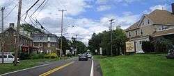
Approaching Penns Park Road from northbound Second Street Pike (PA 232) | |
 Penns Park | |
| Coordinates: 40°15′57″N 74°59′53″W / 40.26583°N 74.99806°WCoordinates: 40°15′57″N 74°59′53″W / 40.26583°N 74.99806°W | |
| Country | United States |
| State | Pennsylvania |
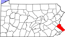
| County | Bucks |
| Township | Wrightstown |
| Elevation | 354 ft (108 m) |
| Time zone | Eastern (EST) (UTC-5) |
| • Summer (DST) | EDT (UTC-4) |
| ZIP code | 18943 |
| Area code(s) | 215 and 267 |
| GNIS feature ID | 1204379[1] |
|
Penns Park Historic District | |
 | |
| Area | 31.5 acres (12.7 ha) |
|---|---|
| Architectural style | Greek Revival, Gothic, Queen Anne |
| NRHP Reference # | 86000349[2] |
| Added to NRHP | March 13, 1986 |
The oldest village in Wrightstown Township, Pennsylvania, Penns Park is located in the center of the township. The zip code is 18943. The crossroads village was known as Logtown as early as 1716 and Pennsville in the early 19th century. In 1862 the village name was changed to its current one. Just outside the village, at the intersection of Penns Park Road and Mud Road, there is still a solitary log house, often called the oldest house in Bucks County. To the southwest of the village is the "old grave yard" where many of the township's first settlers are buried. The Penns Park Historic District and Penn's Park General Store Complex are listed on the National Register of Historic Places.[2]
References
- ↑ "Penns Park". Geographic Names Information System. United States Geological Survey.
- 1 2 National Park Service (2010-07-09). "National Register Information System". National Register of Historic Places. National Park Service.
| Topics |   | |
|---|---|---|
| Lists by county |
| |
| Lists by city | ||
| Other lists | ||
| ||
This article is issued from Wikipedia - version of the 6/29/2016. The text is available under the Creative Commons Attribution/Share Alike but additional terms may apply for the media files.