| [3] |
Name on the Register |
Image |
Date listed[4] |
Location |
Municipality |
Description |
|---|
| 1 |
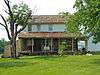
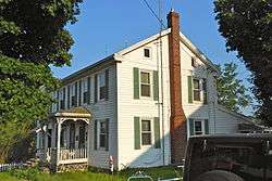
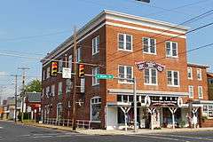
John Abbott House |
|
000000001980-02-22-0000February 22, 1980
(#80003394) |
East King Street
39°53′14″N 76°58′55″W / 39.887222°N 76.981944°W / 39.887222; -76.981944 (John Abbott House) |
Abbottstown |
|
| 2 |
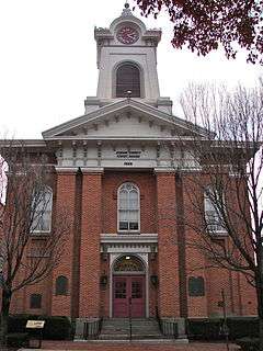
Adams County Courthouse |
|
000000001974-10-01-0000October 1, 1974
(#74001728) |
Baltimore and West Middle Streets
39°49′46″N 77°13′53″W / 39.829583°N 77.231389°W / 39.829583; -77.231389 (Adams County Courthouse) |
Gettysburg |
|
| 3 |
Black Horse Tavern |
|
000000001978-03-30-0000March 30, 1978
(#78002331) |
West of Gettysburg on Pennsylvania Route 116
39°49′08″N 77°17′02″W / 39.818889°N 77.283889°W / 39.818889; -77.283889 (Black Horse Tavern) |
Cumberland Township |
|
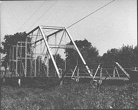
| 4 |
Bridge in Cumberland Township |
|
000000001988-06-22-0000June 22, 1988
(#88000866) |
Legislative Route 01002 over Marsh Creek, near Greenmount
39°45′27″N 77°17′06″W / 39.7575°N 77.285°W / 39.7575; -77.285 (Bridge in Cumberland Township) |
Cumberland and Freedom Townships |
|
| 5 |
Carbaugh Run Rhyolite Quarry Site (36AD30) |
Upload image |
000000001986-01-15-0000January 15, 1986
(#86000817) |
Atop Snaggy Ridge, west of Carbaugh Run[5]
39°53′02″N 77°27′26″W / 39.884°N 77.4573°W / 39.884; -77.4573 (Carbaugh Run Rhyolite Quarry Site (36AD30)) |
Franklin Township |
|
| 6 |
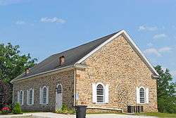
Cline's Church of the United Brethren in Christ |
|
000000002002-08-22-0000August 22, 2002
(#02000894) |
Cline's Church Road, 0.5 miles (0.80 km) south of Pennsylvania Route 34, near Menallen
40°00′02″N 77°13′14″W / 40.000556°N 77.220556°W / 40.000556; -77.220556 (Cline's Church of the United Brethren in Christ) |
Menallen Township |
|
| 7 |
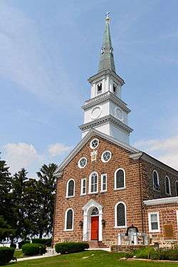
Conewago Chapel |
|
000000001975-01-29-0000January 29, 1975
(#75001604) |
3 miles (4.8 km) northwest of Hanover
39°49′08″N 77°02′17″W / 39.818889°N 77.038056°W / 39.818889; -77.038056 (Conewago Chapel) |
Conewago Township |
|
| 8 |
Dobbin House |
|
000000001973-03-26-0000March 26, 1973
(#73001584) |
89 Steinwehr Avenue
39°49′22″N 77°13′58″W / 39.822778°N 77.232778°W / 39.822778; -77.232778 (Dobbin House) |
Gettysburg |
|
| 9 |
East Berlin Historic District |
|
000000001985-09-30-0000September 30, 1985
(#85002693) |
Portions of King, Harrisburg, and Abbottstown Streets
39°56′17″N 76°58′56″W / 39.938056°N 76.982222°W / 39.938056; -76.982222 (East Berlin Historic District) |
East Berlin |
|
| 10 |
Eisenhower National Historic Site |
|
000000001967-11-27-0000November 27, 1967
(#67000017) |
200 Eisenhower Farm Lane, near Gettysburg
39°47′45″N 77°16′02″W / 39.795833°N 77.267222°W / 39.795833; -77.267222 (Eisenhower National Historic Site) |
Cumberland Township |
|
| 11 |
Fairfield Historic District |
|
000000002000-05-18-0000May 18, 2000
(#00000518) |
Roughly bounded by Landis Drive, Steelman Street, Wortz Drive, and the northwestern borough boundary
39°47′36″N 77°22′10″W / 39.793333°N 77.369444°W / 39.793333; -77.369444 (Fairfield Historic District) |
Fairfield |
|
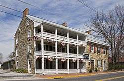
| 12 |
Fairfield Inn |
|
000000001973-04-02-0000April 2, 1973
(#73001583) |
Main Street
39°47′13″N 77°22′11″W / 39.787°N 77.369597°W / 39.787; -77.369597 (Fairfield Inn) |
Fairfield |
|
| 13 |
Gettysburg Armory |
|
000000001990-04-18-0000April 18, 1990
(#90000422) |
315 West Confederate Avenue
39°49′37″N 77°14′38″W / 39.826944°N 77.243889°W / 39.826944; -77.243889 (Gettysburg Armory) |
Gettysburg |
|
| 14 |
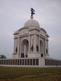
Gettysburg Battlefield Historic District |
|
000000001975-03-19-0000March 19, 1975
(#75000155) |
Town of Gettysburg and its environs
39°48′59″N 77°13′49″W / 39.816389°N 77.230278°W / 39.816389; -77.230278 (Gettysburg Battlefield Historic District) |
Cumberland Township, Gettysburg, and Highland Township |
|
| 15 |
Gettysburg National Military Park |
|
000000001966-10-15-0000October 15, 1966
(#66000642) |
Gettysburg National Military Park, near Gettysburg
39°48′43″N 77°14′39″W / 39.811944°N 77.244167°W / 39.811944; -77.244167 (Gettysburg National Military Park) |
Cumberland, Highland, and Straban Townships |
|
| 16 |
Great Conewago Presbyterian Church |
|
000000001974-12-27-0000December 27, 1974
(#74001730) |
Church Road, near Hunterstown
39°53′15″N 77°09′46″W / 39.8875°N 77.162778°W / 39.8875; -77.162778 (Great Conewago Presbyterian Church) |
Straban Township |
|
| 17 |
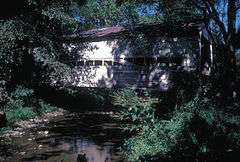
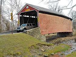
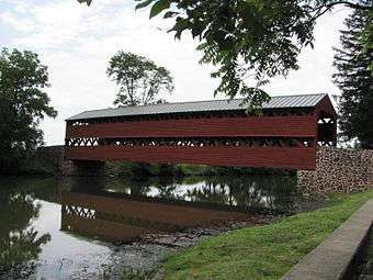
Heikes Covered Bridge |
|
000000001980-08-25-0000August 25, 1980
(#80003396) |
North of Heidlersburg on Township 5857
39°58′41″N 77°08′47″W / 39.978056°N 77.146389°W / 39.978056; -77.146389 (Heikes Covered Bridge) |
Huntington and Tyrone Townships |
|
| 18 |
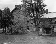
Horner House and Barn |
|
000000002007-05-24-0000May 24, 2007
(#07000468) |
20 Horner Road
39°43′41″N 77°14′59″W / 39.728056°N 77.249722°W / 39.728056; -77.249722 (Horner House and Barn) |
Cumberland Township |
|
| 19 |
Hunterstown Historic District |
|
000000001979-05-15-0000May 15, 1979
(#79002154) |
Pennsylvania Route 394 and Granite Station Road, in Hunterstown
39°53′03″N 77°09′36″W / 39.884167°N 77.16°W / 39.884167; -77.16 (Hunterstown Historic District) |
Straban Township |
|
| 20 |
Jacks Mountain Covered Bridge |
|
000000001980-08-25-0000August 25, 1980
(#80003397) |
Southwest of Fairfield on Legislative Route 01053, near Iron Springs
39°46′01″N 77°23′13″W / 39.766944°N 77.386944°W / 39.766944; -77.386944 (Jacks Mountain Covered Bridge) |
Carroll Valley and Hamiltonban Township |
|
| 21 |
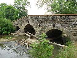
John's Burnt Mill Bridge |
|
000000001974-12-16-0000December 16, 1974
(#74001731) |
Southwest of New Oxford on Township 428
39°49′56″N 77°04′47″W / 39.832222°N 77.079722°W / 39.832222; -77.079722 (John's Burnt Mill Bridge) |
Mount Pleasant and Oxford Townships |
|
| 22 |
Lower Marsh Creek Presbyterian Church |
|
000000001980-10-15-0000October 15, 1980
(#80003399) |
Southeast of Orrtanna on Legislative Route 01002
39°48′42″N 77°19′59″W / 39.811667°N 77.333056°W / 39.811667; -77.333056 (Lower Marsh Creek Presbyterian Church) |
Highland Township |
|
| 23 |
Lutheran Theological Seminary-Old Dorm |
|
000000001974-05-03-0000May 3, 1974
(#74001729) |
Seminary Ridge, Lutheran Theological Seminary campus
39°49′55″N 77°14′41″W / 39.831944°N 77.244722°W / 39.831944; -77.244722 (Lutheran Theological Seminary-Old Dorm) |
Gettysburg |
|
| 24 |
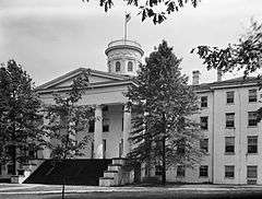
Pennsylvania Hall, Gettysburg College |
|
000000001972-03-16-0000March 16, 1972
(#72001087) |
Gettysburg College campus
39°50′06″N 77°14′05″W / 39.835°N 77.234722°W / 39.835; -77.234722 (Pennsylvania Hall, Gettysburg College) |
Gettysburg |
|
| 25 |
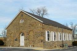
Pleasant Grove School |
|
000000002012-09-04-0000September 4, 2012
(#12000603) |
4084 Baltimore Pike, Germantown
39°45′51″N 77°08′16″W / 39.764041°N 77.137649°W / 39.764041; -77.137649 (Pleasant Grove School) |
Mount Joy Township |
part of the Educational Resources of Pennsylvania Multiple Property Submission (MPS)
|
| 26 |
Pond Mill Bridge |
|
000000001988-06-22-0000June 22, 1988
(#88000816) |
Legislative Route 01009 over Bermudian Creek, near Bermudian
39°59′45″N 77°03′31″W / 39.995833°N 77.058611°W / 39.995833; -77.058611 (Pond Mill Bridge) |
Latimore Township |
|
| 27 |
Rock Creek-White Run Union Hospital Complex |
|
000000002000-05-18-0000May 18, 2000
(#00000520) |
Baltimore Pike, Goulden Road, and White Church Road, near Mount Joy
39°47′20″N 77°11′59″W / 39.788889°N 77.199722°W / 39.788889; -77.199722 (Rock Creek-White Run Union Hospital Complex) |
Cumberland Township, Gettysburg, and Mount Joy Township |
|
| 28 |
Sauck's Covered Bridge |
|
000000001980-08-25-0000August 25, 1980
(#80003395) |
Waterworks Road over Marsh Creek
39°47′51″N 77°16′35″W / 39.7975°N 77.276389°W / 39.7975; -77.276389 (Sauck's Covered Bridge) |
Cumberland and Freedom Townships |
|
| 29 |
Sheads House |
|
000000001976-12-08-0000December 8, 1976
(#76001592) |
331 Buford Avenue
39°50′03″N 77°14′35″W / 39.834167°N 77.243056°W / 39.834167; -77.243056 (Sheads House) |
Gettysburg |
|
| 30 |
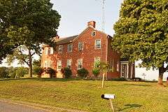
Spangler-Benner Farm |
|
000000001992-10-29-0000October 29, 1992
(#92001493) |
230 Benner Road, near Gettysburg
39°44′39″N 77°13′34″W / 39.744167°N 77.226111°W / 39.744167; -77.226111 (Spangler-Benner Farm) |
Mount Joy Township |
|
| 31 |
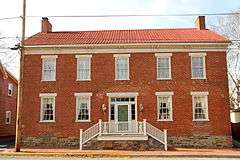
Thomas Brothers Store |
|
000000002008-08-15-0000August 15, 2008
(#08000780) |
4 South Main Street
39°55′49″N 77°14′53″W / 39.93032°N 77.24792°W / 39.93032; -77.24792 (Thomas Brothers Store) |
Biglerville |
|
| 32 |
Wirts House |
|
000000001992-01-22-0000January 22, 1992
(#91002010) |
798 Schrivers Corner Road (Pennsylvania Route 394), near Gettyburg
39°53′45″N 77°11′58″W / 39.895833°N 77.199444°W / 39.895833; -77.199444 (Wirts House) |
Straban Township |
|
| 33 |
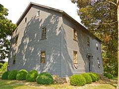
John Zeigler Farm House |
Upload image |
000000001992-05-07-0000May 7, 1992
(#92000395) |
1281 Mountain Road, near York Springs
40°02′56″N 77°07′02″W / 40.048889°N 77.117222°W / 40.048889; -77.117222 (John Zeigler Farm House) |
Latimore Township |
|