Bedminster Township, Bucks County, Pennsylvania
| Bedminster Township, Pennsylvania | |
| Township | |
 | |
| Country | United States |
|---|---|
| State | Pennsylvania |
| County | Bucks |
| Elevation | 341 ft (103.9 m) |
| Coordinates | 40°26′00″N 75°07′23″W / 40.43333°N 75.12306°WCoordinates: 40°26′00″N 75°07′23″W / 40.43333°N 75.12306°W |
| Area | 31.1 sq mi (80.5 km2) |
| - land | 30.2 sq mi (78 km2) |
| - water | 0.9 sq mi (2 km2), 2.89% |
| Population | 6,574 (2010) |
| Density | 159.3/sq mi (61.5/km2) |
| Timezone | EST (UTC-5) |
| - summer (DST) | EDT (UTC-4) |
| Area code | 215 |
 Location of Bedminster Township in Bucks County
| |
 Location of Bedminster Township in Pennsylvania
| |
 Location of Pennsylvania in the United States
| |
Bedminster Township is a township in Bucks County, Pennsylvania, United States. The population was 6,574 at the 2010 census. Bedminster is part of Pennridge School District.
History
The Stover-Myers Mill was listed on the National Register of Historic Places in 1978.[1]
Geography
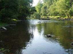
According to the United States Census Bureau, the township has a total area of 31.1 square miles (81 km2), of which, 30.2 square miles (78 km2) of it is land and 1.0 square mile (2.6 km2) of it (3.18%) is water. It is drained by the Tohickon Creek, which forms its northern boundary and drains eastward into the Delaware River. Lake Nockamixon forms much of the NW boundary.
Its villages include Bedminster, Deep Run, Elephant, Griers Corner (also in Hilltown and Plumstead Townships), Hagersville, Keelersville, Kellers Church, Kulps Corner (also in Hilltown Township), Pipersville, and Weisel. The township's numbered routes are 113 (Bedminster Road), 313 (Dublin Pike on the SW border), 413 (Durham Road), and 611 (Easton Road).
Neighboring municipalities
- Tinicum Township (northeast)
- Plumstead Township (southeast)
- Hilltown Township (southwest)
- Dublin (southwest)
- East Rockhill Township (west)
- Haycock Township (northwest)
- Nockamixon Township (north)
Demographics
| Historical population | |||
|---|---|---|---|
| Census | Pop. | %± | |
| 1930 | 2,087 | — | |
| 1940 | 2,088 | 0.0% | |
| 1950 | 2,268 | 8.6% | |
| 1960 | 2,740 | 20.8% | |
| 1970 | 3,252 | 18.7% | |
| 1980 | 3,611 | 11.0% | |
| 1990 | 4,602 | 27.4% | |
| 2000 | 4,804 | 4.4% | |
| 2010 | 6,574 | 36.8% | |
| http://www.dvrpc.org/data/databull/rdb/db82/appedixa.xls | |||
As of the 2010 census, the township was 93.6% White, 0.8% Black or African American, 0.2% Native American, 1.9% Asian, and 1.7% were two or more races. 2.5% of the population were of Hispanic or Latino ancestry.[2]
As of the census[3] of 2000, there were 4,804 people, 1,788 households, and 1,333 families residing in the township. The population density was 159.3 people per square mile (61.5/km²). There were 1,868 housing units at an average density of 61.9/sq mi (23.9/km²). The racial makeup of the township was 98.13% White, 0.58% African American, 0.02% Native American, 0.42% Asian, 0.02% Pacific Islander, 0.19% from other races, and 0.65% from two or more races. Hispanic or Latino of any race were 0.92% of the population.
There were 1,788 households, out of which 32.0% had children under the age of 18 living with them, 65.6% were married couples living together, 6.1% had a female householder with no husband present, and 25.4% were non-families. 19.5% of all households were made up of individuals, and 7.0% had someone living alone who was 65 years of age or older. The average household size was 2.68 and the average family size was 3.13.
In the township the population was spread out, with 24.5% under the age of 18, 6.5% from 18 to 24, 29.3% from 25 to 44, 26.9% from 45 to 64, and 12.8% who were 65 years of age or older. The median age was 40 years. For every 100 females there were 103.3 males. For every 100 females age 18 and over, there were 98.9 males.
The median income for a household in the township was $56,281, and the median income for a family was $64,338. Males had a median income of $42,015 versus $28,024 for females. The per capita income for the township was $29,153. About 2.8% of families and 3.9% of the population were below the poverty line, including 4.2% of those under age 18 and 8.0% of those age 65 or over.
References
- ↑ National Park Service (2010-07-09). "National Register Information System". National Register of Historic Places. National Park Service.
- ↑ "Census 2010: Pennsylvania". Usatoday.Com. Retrieved 2013-07-22.
- ↑ "American FactFinder". United States Census Bureau. Archived from the original on 2013-09-11. Retrieved 2008-01-31.