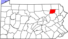
National Register of Historic Places listings in Wyoming County, Pennsylvania
This is a list of the National Register of Historic Places listings in Wyoming County, Pennsylvania.
This is intended to be a complete list of the properties and districts on the National Register of Historic Places in Wyoming County, Pennsylvania, United States. The locations of National Register properties and districts for which the latitude and longitude coordinates are included below, may be seen in a map.[1]
There are 5 properties and districts listed on the National Register in the county.
- This National Park Service list is complete through NPS recent listings posted December 2, 2016.[2]
Current listings
| [3] | Name on the Register | Image | Date listed[4] | Location | City or town | Description |
|---|---|---|---|---|---|---|
| 1 | Bridge in Nicholson Township | 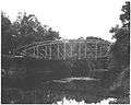 |
(#88000810) |
Legislative Route 65021 over Tunkhannock Creek near Starkville 41°36′17″N 75°49′24″W / 41.604722°N 75.823333°W |
Nicholson Township | |
| 2 | Noxen School | 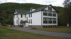 |
(#06000431) |
School Street 41°25′35″N 76°03′20″W / 41.426389°N 76.055556°W |
Noxen Township | |
| 3 | Old White Mill | 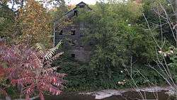 |
(#75001680) |
Off Welles Street 41°36′51″N 76°02′48″W / 41.614167°N 76.046667°W |
Meshoppen | |
| 4 | Tunkhannock Historic District | 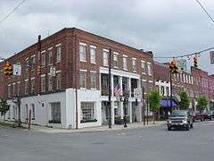 |
(#05000101) |
Roughly bounded by Tioga, Pine, and Harrison Streets and Wyoming Avenue 41°32′23″N 75°56′57″W / 41.539722°N 75.949167°W |
Tunkhannock | |
| 5 | Tunkhannock Viaduct | 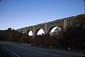 |
(#77001203) |
0.5 miles (0.8 km) east of Nicholson at Tunkhannock Creek 41°37′28″N 75°46′37″W / 41.624444°N 75.776944°W |
Nicholson |
See also
| Wikimedia Commons has media related to National Register of Historic Places in Wyoming County, Pennsylvania. |
References
- ↑ The latitude and longitude information provided in this table was derived originally from the National Register Information System, which has been found to be fairly accurate for about 99% of listings. For about 1% of NRIS original coordinates, experience has shown that one or both coordinates are typos or otherwise extremely far off; some corrections may have been made. A more subtle problem causes many locations to be off by up to 150 yards, depending on location in the country: most NRIS coordinates were derived from tracing out latitude and longitudes off of USGS topographical quadrant maps created under the North American Datum of 1927, which differs from the current, highly accurate WGS84 GPS system used by most on-line maps. Chicago is about right, but NRIS longitudes in Washington are higher by about 4.5 seconds, and are lower by about 2.0 seconds in Maine. Latitudes differ by about 1.0 second in Florida. Some locations in this table may have been corrected to current GPS standards.
- ↑ "National Register of Historic Places: Weekly List Actions". National Park Service, United States Department of the Interior. Retrieved on December 2, 2016.
- ↑ Numbers represent an ordering by significant words. Various colorings, defined here, differentiate National Historic Landmarks and historic districts from other NRHP buildings, structures, sites or objects.
- ↑ The eight-digit number below each date is the number assigned to each location in the National Register Information System database, which can be viewed by clicking the number.
| Topics |   | |
|---|---|---|
| Lists by county |
| |
| Lists by city | ||
| Other lists | ||
| ||
{{US county navigation box | county =Wyoming County | state =Pennsylvania | template_name =Wyoming County, Pennsylvania | listclass =hlist | map_image =Map of Pennsylvania highlighting Wyoming County.svg | map_caption = | seat =Tunkhannock
| title1 =Boroughs | body1 =
| title2 =Townships | body2 =
- Braintrim
- Clinton
- Eaton
- Exeter
- Falls
- Forkston
- Lemon
- Mehoopany
- Meshoppen
- Monroe
- Nicholson
- North Branch
- Northmoreland
- Noxen
- Overfield
- Tunkhannock
- Washington
- Windham
| title3 =CDPs | body3 =
- Lake Winola
- Noxen
- West Falls
- [[Stull, Pennsylvania https://en.wikipedia.org/wiki/Stull,_Pennsylvania
| title4 =Ghost town | body4 =
}}