Neshaminy Falls, Pennsylvania
| Neshaminy Falls, Pennsylvania | |
|---|---|
| Unincorporated community | |
 Neshaminy Falls | |
| Coordinates: 40°9′12″N 74°57′34″W / 40.15333°N 74.95944°WCoordinates: 40°9′12″N 74°57′34″W / 40.15333°N 74.95944°W | |
| Country | United States |
| State | Pennsylvania |
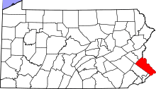
| County | Bucks |
| Township | Bensalem |
| Elevation | 138 ft (42 m) |
| Time zone | Eastern (EST) (UTC-5) |
| • Summer (DST) | EDT (UTC-4) |
| ZIP code | 19053 |
| Area code(s) | 215 and 267 |
| GNIS feature ID | 1182258[1] |
Neshaminy Falls is an unincorporated community in Bensalem Township in Bucks County, Pennsylvania, United States. Neshaminy Falls is located in the northwestern part of the township southwest of Bristol Road. It is served by the Neshaminy Falls station on SEPTA's West Trenton Line. Neshaminy Falls is the eastern end of the Pennsylvania Turnpike's ticket system of tolling.[2]
References
- ↑ "Neshaminy Falls". Geographic Names Information System. United States Geological Survey.
- ↑ Bucks County, Pennsylvania (Map) (19th ed.). 1"=2000'. ADC Map. 2006. p. 3261. § E7. ISBN 0-87530-774-4.
This article is issued from Wikipedia - version of the 11/2/2016. The text is available under the Creative Commons Attribution/Share Alike but additional terms may apply for the media files.