Durham Township, Bucks County, Pennsylvania
| Durham Township | |
| Township | |
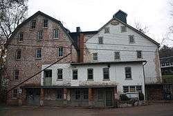 Durham Mill, built 1820 | |
| Country | United States |
|---|---|
| State | Pennsylvania |
| County | Bucks |
| Elevation | 614 ft (187.1 m) |
| Coordinates | 40°34′59″N 75°14′55″W / 40.58306°N 75.24861°WCoordinates: 40°34′59″N 75°14′55″W / 40.58306°N 75.24861°W |
| Area | 9.4 sq mi (24.3 km2) |
| - land | 9.2 sq mi (24 km2) |
| - water | 0.2 sq mi (1 km2), 2.13% |
| Population | 1,144 (2010) |
| Density | 142.6/sq mi (55.1/km2) |
| Established | 1775 |
| Timezone | EST (UTC-5) |
| - summer (DST) | EDT (UTC-4) |
| Area code | 610 |
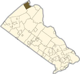 Location of Durham Township in Bucks County | |
 Location of Durham Township in Pennsylvania | |
 Location of Pennsylvania in the United States | |
| Website: http://www.durhamtownship.org/ | |
Durham Township is a township in Bucks County, Pennsylvania, United States. The population was 1,144 at the 2010 census. It was first organized in 1775 and is located in the extreme north of Bucks County. It was the location of Durham Furnace, Durham Boat Company and Durham Mills.
History
The Durham Mill and Furnace was listed on the National Register of Historic Places in 1976.[1]
Geography
According to the United States Census Bureau, the township has a total area of 9.4 square miles (24 km2), of which, 9.2 square miles (24 km2) of it is land and 0.2 square miles (0.52 km2) of it (1.71%) is water. It is drained by the Delaware River which forms its eastern boundary with New Jersey. Its villages include Durham, Durham Furnace, Kintnersville (also in Nockamixon Township,) and Monroe. Route 611 is north-to-south while Route 212 is east-to-west and meets it in Durham Furnace.
Neighboring municipalities
- Springfield Township (west)
- Nockamixon Township (south)
- Holland Township, New Jersey (east)
- Riegelsville (northeast)
- Williams Township, Northampton County (north)
- Lower Saucon Township, Northampton County (tangent to the northwest)
Demographics
| Historical population | |||
|---|---|---|---|
| Census | Pop. | %± | |
| 1930 | 619 | — | |
| 1940 | 636 | 2.7% | |
| 1950 | 668 | 5.0% | |
| 1960 | 735 | 10.0% | |
| 1970 | 781 | 6.3% | |
| 1980 | 915 | 17.2% | |
| 1990 | 1,209 | 32.1% | |
| 2000 | 1,313 | 8.6% | |
| 2010 | 1,144 | −12.9% | |
| http://www.dvrpc.org/data/databull/rdb/db82/appedixa.xls. | |||
As of the 2010 census, the township was 96.6% White, 0.3% Black or African American, 0.1% Native American, 1.0% Asian, and 0.7% were two or more races. 1.3% of the population were of Hispanic or Latino ancestry.[2]
As of the census[3] of 2000, there were 1,313 people, 485 households, and 382 families residing in the township. The population density was 142.6 people per square mile (55.0/km²). There were 525 housing units at an average density of 57.0/sq mi (22.0/km²). The racial makeup of the township was 98.17% White, 0.08% African American, 0.76% Asian, 0.23% from other races, and 0.76% from two or more races. Hispanic or Latino of any race were 1.07% of the population.
There were 485 households, out of which 34.8% had children under the age of 18 living with them, 70.5% were married couples living together, 4.5% had a female householder with no husband present, and 21.2% were non-families. 17.3% of all households were made up of individuals, and 6.4% had someone living alone who was 65 years of age or older. The average household size was 2.71 and the average family size was 3.07.
In the township the population was spread out, with 23.9% under the age of 18, 6.8% from 18 to 24, 28.1% from 25 to 44, 29.3% from 45 to 64, and 11.9% who were 65 years of age or older. The median age was 41 years. For every 100 females there were 114.5 males. For every 100 females age 18 and over, there were 110.8 males.
The median income for a household in the township was $70,875, and the median income for a family was $73,750. Males had a median income of $51,719 versus $34,688 for females. The per capita income for the township was $29,913. 3.9% of the population and 2.7% of families were below the poverty line. Out of the total population, 3.0% of those under the age of 18 and 3.0% of those 65 and older were living below the poverty line.
References
- ↑ National Park Service (2010-07-09). "National Register Information System". National Register of Historic Places. National Park Service.
- ↑ "Census 2010: Pennsylvania". Usatoday.Com. Retrieved 2013-07-22.
- ↑ "American FactFinder". United States Census Bureau. Retrieved 2008-01-31.
External links
| Wikimedia Commons has media related to Durham Township, Bucks County, Pennsylvania. |