Malden, Pennsylvania
| Malden, Pennsylvania | |
|---|---|
| A bedroom community in the Borough of Centerville | |
|
Malden Inn in the borough's Centerville historic district in August 2014 | |
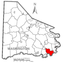 Bedroom Community of Malden in the Borough of Centerville in Washington County, Pennsylvania. | |
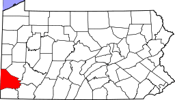
 Malden, Pennsylvania Location of Malden in Pennsylvania[1] | |
| Coordinates: 40°1′17.4″N 79°33′33″W / 40.021500°N 79.55917°WCoordinates: 40°1′17.4″N 79°33′33″W / 40.021500°N 79.55917°W | |
| Country | United States |
| State | Pennsylvania |
| County | Washington |
| Established | 1800 |
| John Krep's Tavern | 1820 |
| Founded by | John Krep |
| Area Malden housing developments were limited to roadside dwellings until the 1950s. Most of the lands now made residential streets off to the side from the Old National Pike were probably farm lands until after WW-II ended. | |
| • Water | 0 sq mi (0 km2) |
| Elevation | 1,181 ft (360 m) |
| Population (2010) | |
| • Total | several dozen houses |
| Time zone | EST (UTC-4) |
| • Summer (DST) | EDT (UTC-5) |
| zipcode | 15417 |
| Area code(s) | 724 (Southwestern Pennsylvania) |

The unincorporated hamlet of Malden is a bedroom community[2] along the historic 'Old National Pike' (1811) within borough of Centerville Washington County, Pennsylvania; Malden, a historical wagon stop during the early 19th century westward migration surge, sits in the apex of a westward pointing triangle formed by the intersection of a 1960s four lane Highway improvement of U.S. Route 40 re-routed as a by-pass of Brownsville's lower business district (path of old U.S. 40) and that old historic National Highway. Thus both US-40 bridges across the Monongahela River, the Lane Bane Bridge and the Brownsville-West Brownsville Bridge connect to their US-40 routes which re-merge at the west side of Malden. Both Malden and Centerville share the 15417 postal zip code of the Brownsville, PA post-office.[lower-alpha 1]
Settled initially about 1800 as the surge of emigration westward across the alleghenies was becoming a deluge, the area's relatively level geography atop the long climb along Nemacolin's Path and the National Road lent itself to emigrant's resting their draft animal teams and camping to recuperate from the arduous mountain experience and ascent from the congestion & hustle and bustle of land limited Brownsville and West Brownsville.
Accordingly, one of the first structures erected was the Malden Inn, which also sat along the road junction with Malden Road, connecting the plateau with California, PA and other developing communities along the left bank Monongahela River. The Inn is located at one side of the small business district and today houses a more modern cultural landmark, Paci's Restaurant, which has served the tri-county area with fine dining and receptions since the 1930s. Within another block, opposite Malden road lies another local multi-county landmark, Cuppies Drive-In Theatre which began operations in 1947[3] and was sold by the family in 1976 and renamed the Malden Drive-In Theater.[4]
Since the 1960s decline in the rust belt economics, the neighborhood has become a commercial backwater (although still desirable as a housing community)—which decline began locally by 1964 due to an improvement rerouting locally the path of US40 —away from the Old National Road and the former path of U.S. Route 40 in eastern Washington County, Pennsylvania —About three miles of US40 was rerouted across the Lane Bane Bridge to bypass the lower business district of downtown Brownsville about 1960-62 mitigating chronic 1950s traffic problems.[lower-alpha 2] The new highway oriented nearly due East-to-West cuts through the neighborhood north of most housing, and cutting Malden Road to California.[lower-alpha 3] The New US40 resumes two lane operation and wyes with the Old National Road at the west end of the community.
The hamlet has an old tavern Landmark and former Inn situated at a Tee-road junction (Malden Road to California and Charleroi) known variously in history as 'John Kreps Tavern',[5] 'The Kreppsville Inn'[6]) and most commonly today, the Malden Inn, a building on the National Register of Historic Places.
Geography
Malden is situated along a 1.75 miles (2.82 km) relatively level strip of land; a stretch of Old U.S. Route 40 where the initial housing lots line the road. Two multi-street housing developments developed during the 1950s, one to either side of the highway. The development to the north is larger and has parallel streets trending up hill street to street. The south side development is a loop, older, and has a fraction of the houses, but over looks the Monongahela Valley unincorporated communities of Denbeau Heights (formerly Denbo Heights) and Denbo respectively, nearer to farther.
Parent community, Brownsville, Pennsylvania was the first possible (closest) place travelers crossing the Alleghenies could reach the waters of the Ohio River and Mississippi River drainage basins. Most river banks were too steep for wagons, and on the convex side of a sweeping curve, Brownsville had several tributary streams cutting across the cliff face formed by the River's cut bank, which served to erode parts forming a ramp-like descent to the river shores.[lower-alpha 4] The opposite shore (West Brownsville also had several climbable slopes and the two banks were connected by a passable ford just upstream of the Brownsville Bridges built in support of the National Road.
Whether by ford or bridges the Cumberland Trail continued westward by climbing up several slopes and about 2.0 miles (3.2 km)[lower-alpha 5] from West Brownsville, the road reached a relatively flat area through Malden, land-linked the Ohio River ford at Wheeling, WV to the river ford between the Brownsville's across the Monongahela River (where the mountainous terrain was behind one's wagon) through the shallow crossing south and upstream of riverboat building center of Brownsville and the flat shores of West Brownsville. The wagon road was an emigrant trail, serving to convey settlers west to the new lands of the Northwest Territory and the Mississippi River basin. The Cumberland Pike began as a privately funded toll road, between Baltimore and Cumberland, Maryland, then gradually extended westwards as improvements could be made. The toll road never reached West of Brownsville, and the balance (eventually reaching Vandalia, Illinois) was built with Federal funds to support westward migration. The part from the Monongahela to the Ohio River crossing at Wheeling, West Virginia, in general, followed the path of the western leg of the long Amerindian trail known as Nemacolin's Path or 'Chief Nemacolin's Trail', as had the Cumberland Pike through the Mountains.
Notes
- ↑ Sharing rural delivery of zip code 15417... as does West Brownsville, Blainsburg, and several other unincorporated communities similar to Malden.
- ↑ with the new road expanded from two lanes to four from the western limit of Malden, nearly to Brier Hill—half-way to Uniontown, Pennsylvania upslope of Brownsville Heights
- ↑ The 'Old National Pike (Old US40) road' had run west then northwest as it climbed the river bank and twisted ascending hilly terrain above that until leveling off through the straight stretch oriented WNW through Malden. Hence the two form a triangle encompassing the larger group of housing streets. Later, in the 1980s, the toll road PA Route 43 was built (originally planned as the 'Mon Valley Expressway', when US Route 40 was improved as described, the MV-Expressway was advertised to join Pittsburgh to communities along the river via Uniontown through Morgantown, WV, Clarksburg and thence to Charleston. It now runs North-South to Uniontown from west of Clairton, but has never been funded to connect the West Virginia communities originally in the proposals and news coverage.
- ↑ Most of the Monongahela Valley has comparatively steep banks, save for the comparatively shallow-sloped shelves which geophysical forces form on the inside sweep of large meander bends opposite the cut banksides. Consequently, an aerial overview up the Mon-valley will notice communities tend to alternate placements to either side of the Monongahela.
- ↑ taking the difference assuming about 1/2 mile from the south housing plan overlooking Denbeau Heights ne' Denbo Heights.[5]
References
- Malden Place, Name: Malden Place ID: 1205066 Class: Populated Place County: Washington Pennsylvania Latitude: 40.0215N Longitude: 079.5550W Elevation: 1,181 feet (360 m) USGS Map name: California
- Search summary
- ↑ GNIS Index: 1205066, TITLE: Malden Place 1205066, classed as: Populated Place Washington County, PA Latitude: 40.0215N Longitude: 079.5550W, USGS Map-California
- ↑ USGS GNIS system identification of Malden Place, index# 1205066
- ↑ Landmark Cuppies Drive-In, later renamed the Malden Drive-in under new management operated for about 60 years before 2007, and was a well known landmark in four counties of Southwestern Pennsylvania.
- ↑ www.cinematreasures.org/theaters/10344
- 1 2 See this photo: 1963 survey of historic places
- ↑ "The Malden Inn". Washington County History & Landmarks Foundation.
The inn, built by Krepps who envisioned a surrounding village, was also known as the Kreppsville Inn.
| Counties |  Map of the Pittsburgh Tri-State with green counties in the metropolitan area and yellow counties in the combined area. | |
|---|---|---|
| Major cities | ||
| Cities and towns 15k-50k (in 2010) | ||
| Airports | ||
| Topics | ||
| ||