Lane Bane Bridge
| Lane Bane Bridge | |
|---|---|
 The bridge's main span crosses the Monongahela. | |
| Coordinates | 40°01′30″N 79°53′06″W / 40.02503°N 79.88509°WCoordinates: 40°01′30″N 79°53′06″W / 40.02503°N 79.88509°W |
| Carries |
4 divided lanes of |
| Crosses | Monongahela River |
| Locale | Brownsville, Pennsylvania and West Brownsville, Pennsylvania |
| Characteristics | |
| Design | Truss bridge |
| Total length | 2,133 feet (650 m) |
| Width | 60 feet (18 m) |
| Longest span | 518 feet (158 m) |
| History | |
| Opened | 1960 |

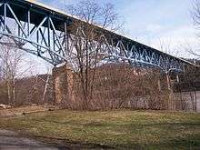
Western portion of span over West Brownsville.
The Lane Bane Bridge is a truss bridge that carries vehicular traffic across the Monongahela River between Brownsville, Pennsylvania and West Brownsville, Pennsylvania. The high level bridge was constructed in 1960 and was originally designed to be part of the Mon-Fayette Expressway. A 3 miles (4.8 km) freeway segment stretches from the west bank of the bridge, and a final exit is contained directly on the eastern shore. The structure is designed not only to provide a river crossing without having to enter the associated deep valley, but it also carries vehicles high above the main streets of West Brownsville.
See also
| Crossings of the Monongahela River | ||||
|---|---|---|---|---|
| ||||
This article is issued from Wikipedia - version of the 10/22/2016. The text is available under the Creative Commons Attribution/Share Alike but additional terms may apply for the media files.