California, Pennsylvania
| California | |
|---|---|
| Borough | |
|
Downtown California | |
| Etymology: U.S. state of California | |
| Nickname(s): Cal | |
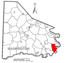 Location of California in Washington County | |
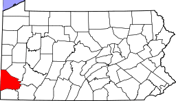
 California Location of California in Pennsylvania | |
| Coordinates: 40°3′55″N 79°53′50″W / 40.06528°N 79.89722°WCoordinates: 40°3′55″N 79°53′50″W / 40.06528°N 79.89722°W | |
| Country | United States |
| State | Pennsylvania |
| County | Washington |
| Established | 1849 |
| Government | |
| • Mayor | Walter Weld |
| Area | |
| • Total | 11.2 sq mi (29 km2) |
| • Land | 11.0 sq mi (28 km2) |
| • Water | 0.2 sq mi (0.5 km2) |
| Population (2010) | |
| • Total | 6,795 |
| • Density | 610/sq mi (230/km2) |
| Time zone | EST (UTC-4) |
| • Summer (DST) | EDT (UTC-5) |
| Area code(s) | 724 |
| Website | www.californiapa15419.com |

California is a borough on the Monongahela River in Washington County, Pennsylvania, United States, and part of the Pittsburgh metropolitan area since 1950.[1] The population was 6,795 as of the 2010 census and was estimated at 6,805 in 2011.[2] California is the home of California University of Pennsylvania. Founded in 1849, the borough was named for the territory of California following the Gold Rush.[3] The borough has had two notably young mayors — Democrat Peter Daley, who was 22 at his election,[4] and Republican Casey Durdines, who was 20 at his election.[5]
Geography
California is located at 40°3′55″N 79°53′50″W / 40.06528°N 79.89722°W (40.065313, -79.897120).[6]
According to the United States Census Bureau, the borough has a total area of 11.2 square miles (29 km2), of which 11.0 square miles (28 km2) is land and 0.2 square miles (0.52 km2) (1.78%) is water.
History
When founded in 1849, the town was named California, though Columbia and Sagamore were names that were also suggested for the new town. Before there were mayors in California, there were burgesses, the first of whom was Solomon Sibbitt.
- East Pike Run Township merged with California Borough in 1953.
- The former Vigilant Mine in California once produced the largest single lump of coal in the world.
- California was once home to the largest soft coal mine in the world when Vesta # 4 opened in 1893.
- The town of Philipsburg used to sit on land that is now occupied by California University of Pennsylvania. This includes the Philipsburg Cemetery, which is still in use and includes a number of graves of Civil War soldiers.
- The first house built in California is next to the California Post Office on Second Street.[3]
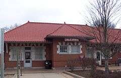
The Molly Fleming House, Jennings-Gallagher House, Malden Inn, Old Main, California State College and former Pennsylvania Railroad Passenger Station are listed on the National Register of Historic Places.[7] The California Boatyards played an important role in building steamboats for western expansion.[8]
Demographics
| Historical population | |||
|---|---|---|---|
| Census | Pop. | %± | |
| 1860 | 476 | — | |
| 1870 | 659 | 38.4% | |
| 1880 | 1,009 | 53.1% | |
| 1890 | 1,024 | 1.5% | |
| 1900 | 2,009 | 96.2% | |
| 1910 | 2,230 | 11.0% | |
| 1920 | 2,480 | 11.2% | |
| 1930 | 2,362 | −4.8% | |
| 1940 | 2,614 | 10.7% | |
| 1950 | 2,831 | 8.3% | |
| 1960 | 5,978 | 111.2% | |
| 1970 | 6,635 | 11.0% | |
| 1980 | 5,703 | −14.0% | |
| 1990 | 5,748 | 0.8% | |
| 2000 | 5,274 | −8.2% | |
| 2010 | 6,795 | 28.8% | |
| Est. 2015 | 6,608 | [9] | −2.8% |
| Sources:[10][11][12] | |||
As of the census[11] of 2000, there were 5,274 people, 1,891 households, and 867 families residing in the borough. The population density was 478.2 people per square mile (184.6/km²). There were 2,092 housing units at an average density of 189.7 per square mile (73.2/km²). The racial makeup of the borough was 93.93% White, 4.13% African American, 0.17% Native American, 0.74% Asian, 0.13% from other races, and 0.89% from two or more races. Hispanic or Latino of any race were 0.49% of the population.

There were 1,891 households out of which 16.4% had children under the age of 18 living with them, 34.8% were married couples living together, 8.0% had a female householder with no husband present, and 54.1% were non-families. 36.6% of all households were made up of individuals and 16.2% had someone living alone who was 65 years of age or older. The average household size was 2.15 and the average family size was 2.85.
In the borough the population was spread out with 10.7% under the age of 18, 42.2% from 18 to 24, 17.3% from 25 to 44, 15.5% from 45 to 64, and 14.3% who were 65 years of age or older. The median age was 24 years. For every 100 females there were 92.8 males. For every 100 females age 18 and over, there were 91.3 males.
The median income for a household in the borough was $24,628, and the median income for a family was $43,168. Males had a median income of $35,833 versus $24,537 for females. The per capita income for the borough was $14,412. About 7.3% of families and 22.3% of the population were below the poverty line, including 14.7% of those under age 18 and 8.1% of those age 65 or over.
Education
Notable people
- Viola Liuzzo, a Unitarian Universalist and civil rights activist murdered in the events of Bloody Sunday, in Selma, Alabama, on March 7, 1965. She was born in California.
- Joseph A. "Jock" Yablonski, an American labor leader in the United Mine Workers in the 1950s and 1960s. He was murdered in 1969 by killers hired by a union political opponent. Longtime resident of California.
- Bruce Dal Canton, a major league pitcher for the Pittsburgh Pirates, Kansas City Royals, Atlanta Braves and Chicago White Sox. Born in California.
- Bert Humphries, a major league pitcher for the Philadelphia Phillies, Cincinnati Reds and Chicago Cubs in the early 20th century. Born in California.
- Don LeJohn, a Major League Baseball third baseman and Minor League Baseball manager. LeJohn was signed by the Brooklyn Dodgers in 1954 and played in the minor leagues through 1971 with various Dodgers affiliates. Resident of California.
References
- ↑
- ↑ "State & County QuickFacts". U.S. Census Bureau. 2011. Retrieved September 13, 2012.
- 1 2 "About California, PA". Borough of California, Pennsylvania. Retrieved 21 December 2009.
- ↑ "California kid prevails" in the Pittsburgh Tribune-Review
- ↑ "Young mayor ready for office" By KAYLA GATALICA of the Pittsburgh Tribune-Review
- ↑ "US Gazetteer files: 2010, 2000, and 1990". United States Census Bureau. 2011-02-12. Retrieved 2011-04-23.
- ↑ National Park Service (2010-07-09). "National Register Information System". National Register of Historic Places. National Park Service.
- ↑ "California Boatyards - PHMC Historical Markers" (Database search). Historical Marker Database. Pennsylvania Historical & Museum Commission. Retrieved January 5, 2013.
- ↑ "Annual Estimates of the Resident Population for Incorporated Places: April 1, 2010 to July 1, 2015". Retrieved July 2, 2016.
- ↑ "Census of Population and Housing". U.S. Census Bureau. Archived from the original on 11 May 2015. Retrieved 11 December 2013.
- 1 2 "American FactFinder". United States Census Bureau. Archived from the original on 2013-09-11. Retrieved 2008-01-31.
- ↑ "Incorporated Places and Minor Civil Divisions Datasets: Subcounty Resident Population Estimates: April 1, 2010 to July 1, 2012". Population Estimates. U.S. Census Bureau. Archived from the original on 17 June 2013. Retrieved 11 December 2013.
External links
| Wikimedia Commons has media related to California, Pennsylvania. |
| Counties |  Map of the Pittsburgh Tri-State with green counties in the metropolitan area and yellow counties in the combined area. | |
|---|---|---|
| Major cities | ||
| Cities and towns 15k-50k (in 2010) | ||
| Airports | ||
| Topics | ||
| ||