Mount Pleasant Township, Washington County, Pennsylvania
| Mount Pleasant Township | |
|---|---|
| Township | |
|
Looking west near 78 Main Street in Hickory | |
 Location of Mount Pleasant Township in Washington County | |
 Location of Washington County in Pennsylvania | |
| Country | United States |
| State | Pennsylvania |
| County | Washington County |
| Established | May 10, 1788 |
| Area | |
| • Total | 35.7 sq mi (92 km2) |
| • Land | 35.6 sq mi (92 km2) |
| • Water | 0.1 sq mi (0.3 km2) |
| Population (2000) | |
| • Total | 3,422 |
| • Density | 96/sq mi (37/km2) |
| Time zone | EST (UTC-5) |
| • Summer (DST) | EDT (UTC-4) |
| Area code(s) | 724 |
| Website | www.mpt-pa.com |

Mount Pleasant Township is a township in Washington County, Pennsylvania, in the United States. As of the 2000 census, the township population was 3,422.
History
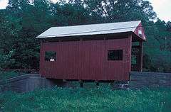
The Krepps Covered Bridge was listed on the National Register of Historic Places in 1979.[1]
Geography
According to the United States Census Bureau, the township has a total area of 35.7 square miles (92.5 km²), of which, 35.6 square miles (92.3 km²) of it is land and 0.1 square miles (0.2 km²) of it (0.22%) is water.
Hickory tunnel
Hickory Tunnel is a railway tunnel in Mount Pleasant Township, Washington County, Pennsylvania. The nearest major town is Hickory, Pennsylvania, where the tunnel passes under Pennsylvania Route 50. The elevation of the tunnel is 1286 feet.
Transport
Rail
McGugin Tunnel is a railway tunnel in Mount Pleasant Township, Washington County, Pennsylvania. It is located at latitude - longitude coordinates of N 40.28674 and W -80.33173. The nearest major town is Hickory, Pennsylvania, where it passes under Pennsylvania Route 18. The tunnel is at an elevation of 1263 feet.
Demographics
As of the census[2] of 2000, there were 3,422 people, 1,279 households, and 1,006 families residing in the township. The population density was 96.0 people per square mile (37.1/km²). There were 1,348 housing units at an average density of 37.8/sq mi (14.6/km²). The racial makeup of the township was 96.49% White, 2.98% African American, 0.09% Asian, and 0.44% from two or more races. Hispanic or Latino of any race were 0.09% of the population.
There were 1,279 households out of which 32.5% had children under the age of 18 living with them, 66.1% were married couples living together, 9.0% had a female householder with no husband present, and 21.3% were non-families. 18.9% of all households were made up of individuals and 9.8% had someone living alone who was 65 years of age or older. The average household size was 2.67 and the average family size was 3.06.
In the township the population was spread out with 24.0% under the age of 18, 7.1% from 18 to 24, 27.7% from 25 to 44, 25.7% from 45 to 64, and 15.6% who were 65 years of age or older. The median age was 40 years. For every 100 females there were 100.0 males. For every 100 females age 18 and over, there were 98.9 males.
The median income for a household in the township was $41,172, and the median income for a family was $48,915. Males had a median income of $35,750 versus $22,917 for females. The per capita income for the township was $18,800. About 3.6% of families and 5.3% of the population were below the poverty line, including 5.9% of those under age 18 and 7.9% of those age 65 or over.
References
- ↑ National Park Service (2010-07-09). "National Register Information System". National Register of Historic Places. National Park Service.
- ↑ "American FactFinder". United States Census Bureau. Retrieved 2008-01-31.
External links
| Counties |  Map of the Pittsburgh Tri-State with green counties in the metropolitan area and yellow counties in the combined area. | |
|---|---|---|
| Major cities | ||
| Cities and towns 15k-50k (in 2010) | ||
| Airports | ||
| Topics | ||
| ||
Coordinates: 40°19′59″N 80°17′59″W / 40.333°N 80.2997°W