Lovington, Somerset
| Lovington | |
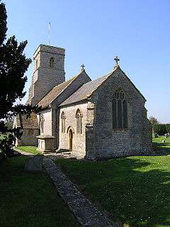 Church of St Thomas of Canterbury, Lovington |
|
 Lovington |
|
| Population | 141 (2011)[1] |
|---|---|
| OS grid reference | ST595305 |
| District | South Somerset |
| Shire county | Somerset |
| Region | South West |
| Country | England |
| Sovereign state | United Kingdom |
| Post town | Castle Cary |
| Postcode district | BA7 |
| Dialling code | 01963 |
| Police | Avon and Somerset |
| Fire | Devon and Somerset |
| Ambulance | South Western |
| EU Parliament | South West England |
| UK Parliament | Somerton and Frome |
Coordinates: 51°04′20″N 2°34′46″W / 51.0723°N 2.5794°W
Lovington is a village and civil parish in Somerset, England, situated 3 miles (4.8 km) south west of Castle Cary, between the River Brue and River Cary, in the South Somerset district. The parish, which includes the hamlet of Wheathill, has a population of 141.[1]
History
The name of the village comes from Old English meaning Lufa's settlement.[2]
There was a mill on the River Brue in the village at the time of the Domesday Book, when it was held by Serlo de Burci,[2] however it is not certain whether this is the same site as the current Lovington Mill which was built around 1800.[3]
The parish of Lovington was part of the hundred of Catsash, while Wheathill was part of the Whitley Hundred.[4]
The village school was built in the early 19th century,[5] and was helped later in the century, with donations and equipment, by the local priest and hymn writer Godfrey Thring.
Governance
The parish council has responsibility for local issues, including setting an annual precept (local rate) to cover the council’s operating costs and producing annual accounts for public scrutiny. The parish council evaluates local planning applications and works with the local police, district council officers, and neighbourhood watch groups on matters of crime, security, and traffic. The parish council's role also includes initiating projects for the maintenance and repair of parish facilities, as well as consulting with the district council on the maintenance, repair, and improvement of highways, drainage, footpaths, public transport, and street cleaning. Conservation matters (including trees and listed buildings) and environmental issues are also the responsibility of the council.
The village falls within the Non-metropolitan district of South Somerset, which was formed on 1 April 1974 under the Local Government Act 1972, having previously been part of Wincanton Rural District.[6] The district council is responsible for local planning and building control, local roads, council housing, environmental health, markets and fairs, refuse collection and recycling, cemeteries and crematoria, leisure services, parks, and tourism.
Somerset County Council is responsible for running the largest and most expensive local services such as education, social services, libraries, main roads, public transport, policing and fire services, trading standards, waste disposal and strategic planning.
It is also part of the Somerton and Frome county constituency represented in the House of Commons of the Parliament of the United Kingdom. It elects one Member of Parliament (MP) by the first past the post system of election, and part of the South West England constituency of the European Parliament which elects seven MEPs using the d'Hondt method of party-list proportional representation.
Religious sites
The Anglican parish Church of St Thomas of Canterbury has 13th-century origins and was restored and enlarged in 1861. It has been designated as a Grade II* listed building.[7] The Church of St John Baptist was converted into a private house in the 1970s.[8]
In the 1780s Thomas Charles held the curacy of Lovington along with several other local parishes.
References
- 1 2 "Statistics for Wards, LSOAs and Parishes — SUMMARY Profiles" (Excel). Somerset Intelligence. Retrieved 4 January 2014.
- 1 2 Bush, Robin (1994). Somerset: The complete guide. Wimborne: The Dovecote Press Ltd. p. 133. ISBN 1-874336-26-1.
- ↑ "Lovington Mill House and the Mill attached". Images of England. English Heritage. Retrieved 24 January 2009.
- ↑ "Somerset Hundreds". GENUKI. Retrieved 22 October 2011.
- ↑ "Lovington School with adjoining School House". Images of England. English Heritage. Retrieved 24 January 2009.
- ↑ "Wincanton RD". A vision of Britain Through Time. University of Portsmouth. Retrieved 4 January 2014.
- ↑ "Church of St Thomas of Cantebury". Images of England. English Heritage. Retrieved 24 January 2009.
- ↑ "Church of St John Baptist". Images of England. English Heritage. Retrieved 24 January 2009.
External links
![]() Media related to Lovington, Somerset at Wikimedia Commons
Media related to Lovington, Somerset at Wikimedia Commons
