Seavington St Michael
| Seavington St Michael | |
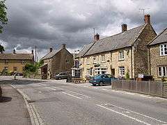 Volunteer Inn, Seavington St. Michael |
|
 Seavington St Michael |
|
| Population | 127 (2011)[1] |
|---|---|
| OS grid reference | ST407151 |
| District | South Somerset |
| Shire county | Somerset |
| Region | South West |
| Country | England |
| Sovereign state | United Kingdom |
| Post town | ILMINSTER |
| Postcode district | TA19 0 |
| Dialling code | 01460 |
| Police | Avon and Somerset |
| Fire | Devon and Somerset |
| Ambulance | South Western |
| EU Parliament | South West England |
| UK Parliament | Yeovil |
Coordinates: 50°55′58″N 2°50′42″W / 50.9328°N 2.8449°W
Seavington St Michael is a village and civil parish in Somerset, England. It is situated next to the village of Seavington St Mary, about 3 miles (4.8 km) east of Ilminster, within the South Somerset district.
The villages lie in a hollow within a larger area of low-lying hills and valleys running broadly east-west. A part of the South Petherton Hundred,[2] originally the area included seven settlements (seven tons) which have gradually merged or vanished, but were the origin of the Seavington part of the village name.[3]
History
The manor was held by Siward the falconer at the time of the Domesday Book in 1086. By 1252 to Adam the Dane then becoming known as Seavington Dennis. From 1483 to 1539 it was held by Glastonbury Abbey and after the dissolution of the monasteries passed to Winchester College, who held it until 1932.[3]
Seavington St Michael, whilst the smaller of the two villages with 57 dwellings and 125 inhabitants,[4] appears to have become the more important since the motor car forced the building of New Road to straighten the London to Exeter route early in the 20th century, thus by-passing Seavington St Mary. Since then, in 1988 the new Ilminster by-pass has taken away much traffic, although the road through Seavington St Michael is still a major access route to the market town of Ilminster.
Governance
The parish council has responsibility for local issues, including setting an annual precept (local rate) to cover the council’s operating costs and producing annual accounts for public scrutiny. The parish council evaluates local planning applications and works with the local police, district council officers, and neighbourhood watch groups on matters of crime, security, and traffic. The parish council's role also includes initiating projects for the maintenance and repair of parish facilities, as well as consulting with the district council on the maintenance, repair, and improvement of highways, drainage, footpaths, public transport, and street cleaning. Conservation matters (including trees and listed buildings) and environmental issues are also the responsibility of the council.
The village falls within the Non-metropolitan district of South Somerset, which was formed on 1 April 1974 under the Local Government Act 1972, having previously been part of Chard Rural District.[5] The district council is responsible for local planning and building control, local roads, council housing, environmental health, markets and fairs, refuse collection and recycling, cemeteries and crematoria, leisure services, parks, and tourism.
Somerset County Council is responsible for running the largest and most expensive local services such as education, social services, libraries, main roads, public transport, policing and fire services, trading standards, waste disposal and strategic planning.
It is also part of the Yeovil county constituency represented in the House of Commons of the Parliament of the United Kingdom. It elects one Member of Parliament (MP) by the first past the post system of election, and part of the South West England constituency of the European Parliament which elects seven MEPs using the d'Hondt method of party-list proportional representation.
Religious sites
The Anglican parish Church of St Michael dates from the late 12th century. It was given a porch around 1291, further alterations in the 15th century and a gallery was added around 1800. It has been designated as a Grade II* listed building.[6]
References
- ↑ "Statistics for Wards, LSOAs and Parishes — SUMMARY Profiles" (Excel). Somerset Intelligence. Retrieved 4 January 2014.
- ↑ "Somerset Hundreds". GENUKI. Retrieved 20 October 2011.
- 1 2 Bush, Robin (1994). Somerset: The Complete Guide. Dovecote Press. p. 176. ISBN 1-874336-26-1.
- ↑ "The two villages". The Seavingtons. Retrieved 2009-03-15.
- ↑ "Chard RD". A vision of Britain Through Time. University of Portsmouth. Retrieved 4 January 2014.
- ↑ "Church of St Michael". Images of England. English Heritage. Retrieved 2009-02-06.
External links
![]() Media related to Seavington St Michael at Wikimedia Commons
Media related to Seavington St Michael at Wikimedia Commons
