Martock

Coordinates: 50°58′13″N 2°45′55″W / 50.9704°N 2.7653°W
Martock is a large village and civil parish in Somerset, England, situated on the edge of the Somerset Levels 7 miles (11.3 km) north west of Yeovil in the South Somerset district. The parish includes Hurst, approximately one mile south of the village, and Bower Hinton, which is located at the western end of the village and bounded by Hurst and the A303. Martock has a population of 4,766[1] and was historically a market town.[2]
History
Etymology
Martock was known in the Domesday Book of 1086 as Mertoch. It means ‘Rising bright from the shining sea’ from the Old English ‘meretorht’. It was the property of Queen Edith (Eagdith), wife of Godwin and mother of Earl Harold (Harold II). By 1066 it was the property of Queen Edith, wife of Edward the Confessor. The word root ‘Mer-’ can also refer to ‘a boundary or shore line’ from the Old English ‘maere’. It is possible that the name included the Old English element ‘stoc’ meaning ‘by a lake’.[3]
An alternative theory to the origin of the name Martock comes from the Old English words "mart" meaning market and "ac" for oak. This might relate to an oak tree on the spot now occupied by the Market House[4] or more precisely the column there.[2] Ekwall suggested that the name derives from ‘merkestoc’ meaning ‘a place on a boundary’.[5] However, Prebendary G.W. Saunders, vicar of Martock from 1917 to 1951, cites two more possibilities. Firstly, from Collinson, who wrote in 1790, that the name Martock is derived from ‘market oak’. But unfortunately Martock was not granted a market until 1247 and long before that it was called by this name. His second suggestion is that the name is derived from a Celtic personal name ‘Merti’, who gave his name to a settlement, hence Merti-oc, the settlement of Merti. Both of these seem to be flights of fancy.[6]
Bower Hinton was called ‘Hanton Mertoc’ in 1225 and ‘Burhenton’ in 1280. ‘Hinton’ meaning a poor enclosure, from the Old English ‘hean’ and ‘tun’.[3]
Newton means the new enclosure from the Old English ‘niwe’ and ‘tun’. The medieval hamlet of Newton, which lay between Bower Hinton and Hurst, was first referred to in 1327.[3] Stapleton was first recorded in 1195. It means the steep enclosure from the Old English ‘steap’ and ‘tun’. Alternatively it may be from the Old English ‘stapel’ and ‘tun’, meaning ‘settlement by a post’.[3]
Domesday book
Martock had a single entry in the Domesday book and expanded rapidly in the succeeding years to include dependent settlements at Bower Hinton, Hurst, Newton, Coat, Stapleton, Ash, Witcombe, Milton and Long Load, expanding between 1086 and 1302 from 89 tenants to more than 200.[7] It was the only parish in the Martock Hundred.[8][9][10]
Later history
In 1810 1,025 acres of common land were enclosed as a result of the Inclosure Acts.[11]
The village was once a junction on local branches of the Great Western Railway, now dismantled.
Governance
The parish council has responsibility for local issues, including setting an annual precept (local rate) to cover the council’s operating costs and producing annual accounts for public scrutiny. The parish council evaluates local planning applications and works with the local police, district council officers, and neighbourhood watch groups on matters of crime, security, and traffic. The parish council's role also includes initiating projects for the maintenance and repair of parish facilities, as well as consulting with the district council on the maintenance, repair, and improvement of highways, drainage, footpaths, public transport, and street cleaning. Conservation matters (including trees and listed buildings) and environmental issues are also the responsibility of the council.
The village falls within the Non-metropolitan district of South Somerset, which was formed on 1 April 1974 under the Local Government Act 1972, having previously been part of Yeovil Rural District.[12] The district council is responsible for local planning and building control, local roads, council housing, environmental health, markets and fairs, refuse collection and recycling, cemeteries and crematoria, leisure services, parks, and tourism.
Somerset County Council is responsible for running the largest and most expensive local services such as education, social services, libraries, main roads, public transport, policing and fire services, trading standards, waste disposal and strategic planning.
An electoral ward exists in the same name. Although Martock is the most populous area the ward stretches north to Long Load. The total population of this ward taken at the 2011 census was 5,724.[13]
It is also part of the Somerton and Frome county constituency represented in the House of Commons of the Parliament of the United Kingdom. It elects one Member of Parliament (MP) by the first past the post system of election, and part of the South West England constituency of the European Parliament which elects seven MEPs using the d'Hondt method of party-list proportional representation.
Economy
Local businesses include arts and crafts (stonemasonry, woodworking, silversmithing) a reclamation yard,[14] and a fish and chip shop. Historically a market town, these days a monthly farmers market is held in Martock.[15]
Landmarks

The Treasurer's House is a National Trust-owned property built from hamstone during the 13th century.[16]
Notable dwelling houses include Church Lodge.
Local places of interest include the Burrow Hill Cider Farm.
The Parrett Iron Works was a series of industrial buildings next to the River Parrett.The site was originally named Carey's Mill and the adjoining bridge is called Carey's Mill Bridge which was built of Ham stone in the 18th century.[17] The Iron Works was founded in 1855,[18][19] on the site of a former snuff mill.[20] The site included a foundry, with a prominent chimney,[21] ropewalk,[22] workshops[23][24] and several smaller workshops and cottages.[25][26][27][28] The sluice which powered the waterwheel[29] and sluice keepers cottage still exist.[30]
The hamstone Market House on Church Street was built around 1753 and restored and reopened in 1960. It is a Grade II listed building.[31] Grants of over £200,000 have been obtained to restore the building and establish a community office.[32] In front of the Market House is a Market Cross, also known as The Pinnacle, with a column which dates from 1741 with a fluted Tuscan column, on a stepped plinth, which supports a ball finial crowned with a wrought-iron weathervane.[33]
Madey Mill is a Grade II* listed watermill with medieval origins. The current buildings date from the 17th century.[34] It has suffered from a lack of maintenance and has been placed on the Heritage at Risk register.[35]
Religious sites
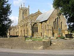
The Church of All Saints dates from the 13th century. It was acquired by the Treasurer of Wells Cathedral in 1227 and he became the rector and patron of the church.[36] The church was restored by Benjamin Ferrey, who was architect to the Diocese of Bath and Wells from 1841 until his death, and also in 1883–84 by Ewan Christian. The tower was built in four stages, to replace the previous one over the central crossing. It has offset corner buttresses to the full height of the tower. The church has been designated by English Heritage as a Grade I listed building.[37] It is said to be the second largest in Somerset and has unique carved wooden statues in the eaves.
References
- 1 2 "Statistics for Wards, LSOAs and Parishes — SUMMARY Profiles" (Excel). Somerset Intelligence. Retrieved 4 January 2014.
- 1 2 West Country Genealogy Martock Parish, Somerset
- 1 2 3 4 Robinson, Stephen (1992). Somerset Place Names. Wimborne, Dorset: The Dovecote Press Ltd. p. 95. ISBN 1-874336-03-2.
- ↑ Robinson, W.J. (1915). West Country Churches. Bristol: Bristol Times and Mirror Ltd. pp. 6–10.
- ↑ Ekwall, Eilert (1940). The Concise Dictionary of English Place-names (2nd ed.). Oxford: Clarendon Press. p. 317.
- ↑ ‘The Hundred of Martock’, Prebendary G.W. Saunders, Yeovil (Western Gazette), 1933-34.
- ↑ Havinden, Michael. The Somerset Landscape. The making of the English landscape. London: Hodder and Stoughton. pp. 107–108. ISBN 0-340-20116-9.
- ↑ "Hundred: Martock". Open Domesday. Retrieved 23 October 2011.
- ↑ "The Hundred of Martock". Martock Local History Club. Retrieved 23 October 2011.
- ↑ R.W. Dunning (editor), A.P. Baggs, R.J.E. Bush (1978). "Martock Hundred: Introduction". A History of the County of Somerset: Volume 4. Institute of Historical Research. Retrieved 23 October 2011.
- ↑ Havinden, Michael (1982). The Somerset Landscape. The making of the English landscape. London: Hodder and Stoughton. p. 133. ISBN 0-340-20116-9.
- ↑ "Yeovil RD". A vision of Britain Through Time. University of Portsmouth. Retrieved 4 January 2014.
- ↑ "ward population 2011.Retrieved 4 March 2015".
- ↑ "Castle reclamation". Castle reclamation. Retrieved 5 May 2010.
- ↑ Martock Online Farmers Market
- ↑ "The Treasurer's House". Images of England. Retrieved 2007-10-30.
- ↑ "Carey's Mill Bridge". Images of England. English Heritage. Retrieved 12 February 2010.
- ↑ "Mill at Parrett Iron Works". Images of England. English Heritage. Retrieved 12 February 2010.
- ↑ "Former rope walk, about 65 metres south-east of main building, Parrett Iron Works, Carey's Mill". Somerset Historic Environment Record. Somerset County Council. Retrieved 12 February 2010.
- ↑ "Mill at Parrett Iron Works, Martock, Somerset". Heritage Explorer. English Heritage. Retrieved 12 February 2010.
- ↑ "Boiler Chimney". Images of England. English Heritage. Retrieved 12 February 2010.
- ↑ "Former Rope Walk etc, Carey's Mill". Images of England. English Heritage. Retrieved 12 February 2010.
- ↑ "Workshop buildings etc, Carey's Mill.". Images of England. English Heritage. Retrieved 12 February 2010.
- ↑ "Workshop building etc. Carey's Mill". Images of England. English Heritage. Retrieved 12 February 2010.
- ↑ "Nos. 1 & 2 Parrett Works Cottages". Images of England. English Heritage. Retrieved 12 February 2010.
- ↑ "Nos. 3 & 4 Parrett Works Cottages". Images of England. English Heritage. Retrieved 12 February 2010.
- ↑ "Nos. 5 & 6 Parrett Works Cottages". Images of England. English Heritage. Retrieved 12 February 2010.
- ↑ "Carey's Mill Cottage". Images of England. English Heritage. Retrieved 12 February 2010.
- ↑ "Waterwheel house". Images of England. English Heritage. Retrieved 12 February 2010.
- ↑ "Sluice and sluice keepers house". Images of England. English Heritage. Retrieved 12 February 2010.
- ↑ "The Market House". Images of England. English Heritage. Retrieved 14 May 2010.
- ↑ "Martock Community Office". Somerset Rural Renaissance. Retrieved 14 May 2010.
- ↑ "Market Cross". Images of England. English Heritage. Retrieved 14 May 2010.
- ↑ "Madey Mill". National Heritage List for England. English Heritage. Retrieved 19 October 2013.
- ↑ "Madey Mill, East Street, Martock - South Somerset". Heritage at Risk. English Heritage. Retrieved 19 October 2013.
- ↑ Leete-Hodge, Lornie (1985). Curiosities of Somerset. Bodmin: Bossiney Books. p. 81. ISBN 0-906456-98-3.
- ↑ "Church of All Saints". Images of England. Retrieved 2008-03-02.
External links
| Wikimedia Commons has media related to Martock. |
- Community website: Martock Online
- GENUKI: Martock
- The Somerset Urban Archaeological Survey: Martock, by Miranda Richardson
