Barrington, Somerset

Coordinates: 50°57′45″N 2°52′37″W / 50.9626°N 2.8770°W
Barrington is a village and civil parish, situated 10 miles (16.1 km) south east of Taunton and 10 miles (16.1 km) west of Yeovil in the South Somerset district of Somerset, England. The village has a population of 438.[1]
The village is located on the southern edge of the Somerset Levels and many of the houses are built from cob and thatched with local reeds.
History
The parish of Barrington was part of the South Petherton Hundred.[2]
Governance
The parish council has responsibility for local issues, including setting an annual precept (local rate) to cover the council’s operating costs and producing annual accounts for public scrutiny. The parish council evaluates local planning applications and works with the local police, district council officers, and neighbourhood watch groups on matters of crime, security, and traffic. The parish council's role also includes initiating projects for the maintenance and repair of parish facilities, as well as consulting with the district council on the maintenance, repair, and improvement of highways, drainage, footpaths, public transport, and street cleaning. Conservation matters (including trees and listed buildings) and environmental issues are also the responsibility of the council.
The village falls within the Non-metropolitan district of South Somerset, which was formed on 1 April 1974 under the Local Government Act 1972, having previously been part of Langport Rural District.[3] The district council is responsible for local planning and building control, local roads, council housing, environmental health, markets and fairs, refuse collection and recycling, cemeteries and crematoria, leisure services, parks, and tourism.
Somerset County Council is responsible for running the largest and most expensive local services such as education, social services, libraries, main roads, public transport, policing and fire services, trading standards, waste disposal and strategic planning.
It is located in the Somerton and Frome parliamentary constituency represented in the House of Commons of the Parliament of the United Kingdom. It elects one Member of Parliament (MP) by the first past the post system of election, and part of the South West England constituency of the European Parliament which elects seven MEPs using the d'Hondt method of party-list proportional representation.
Landmarks
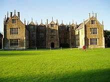
Barrington Court, the local manor house, is a fine Tudor building which anticipates some features of the later Elizabethan style. It was built around 1514 for Henry Daubeney, perhaps finished as late as 1558 for William Clifton. The interior was virtually gutted in 1825, and restored in 1921–25 by Forbes and Tate for A.A. Lyle having passed to the National Trust in 1908. It is a Grade I listed building.[4]
Religious sites
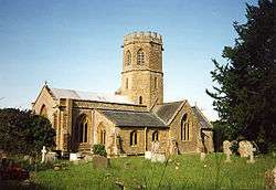
The 13th-century St Mary's Church has an unusual octagonal tower, which includes a bell dating from 1743 and made by Thomas Bilbie of the Bilbie family.[5] It has been designated by English Heritage as a Grade I listed building.[6]
References
- 1 2 "Statistics for Wards, LSOAs and Parishes — SUMMARY Profiles" (Excel). Somerset Intelligence. Retrieved 4 January 2014.
- ↑ "Somerset Hundreds". GENUKI. Retrieved 20 October 2011.
- ↑ "Langport RD". A vision of Britain Through Time. University of Portsmouth. Retrieved 4 January 2014.
- ↑ "Barrington Court". Images of England. Archived from the original on 14 November 2007. Retrieved 2006-12-16.
- ↑ Moore, James; Rice, Roy; Hucker, Ernest (1995). Bilbie and the Chew Valley clock makers. The authors. ISBN 0-9526702-0-8.
- ↑ "Church of St. Mary the Virgin". Images of England. Archived from the original on 18 October 2012. Retrieved 2007-10-05.
External links
| Wikimedia Commons has media related to Barrington, Somerset. |
- Barrington in the Domesday Book
