Chiselborough
| Chiselborough | |
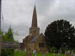 The parish church of Saint Peter and Saint Paul |
|
 Chiselborough |
|
| Population | 275 (2011)[1] |
|---|---|
| OS grid reference | ST469148 |
| District | South Somerset |
| Shire county | Somerset |
| Region | South West |
| Country | England |
| Sovereign state | United Kingdom |
| Post town | STOKE-SUB-HAMDON |
| Postcode district | TA14 6 |
| Dialling code | 01935 |
| Police | Avon and Somerset |
| Fire | Devon and Somerset |
| Ambulance | South Western |
| EU Parliament | South West England |
| UK Parliament | Yeovil |
Coordinates: 50°55′49″N 2°45′21″W / 50.9303°N 2.7558°W
Chiselborough is a village in the South Somerset district of Somerset, England. It is situated on the River Parrett, 5 miles (8 km) west of Yeovil, and has a population of 275.[1]
The village consists largely of small cottages built in the local golden hamstone quarried at the local Ham Hill.
History
The village was recorded in Saxon times as ‘Ceoselbergon’ and was later mentioned in the Domesday Book as ‘Ceolseberge’ in the holding of Robert, Count of Mortain. The name derives from the Old English cisel and beorg (gravel and hill).[2]
The parish was part of the hundred of Houndsborough.[3]
The Earls of Ilchester held most of the village until 1914 when the estate was sold, having inherited it from the heirs of Joan Wadham, Lady Strangways, first wife of Sir Giles Strangways (1528-1562) of Melbury Sampford, sister and co-heiress of Nicholas Wadham, co-founder of Wadham College, Oxford. The current Baron and Baroness of Chiselborough do not reside in the area.
The annual Chiselborough Fair was held on common ground near the street now known as Fair Place.
Governance
The parish council has responsibility for local issues, including setting an annual precept (local rate) to cover the council’s operating costs and producing annual accounts for public scrutiny. The parish council evaluates local planning applications and works with the local police, district council officers, and neighbourhood watch groups on matters of crime, security, and traffic. The parish council's role also includes initiating projects for the maintenance and repair of parish facilities, as well as consulting with the district council on the maintenance, repair, and improvement of highways, drainage, footpaths, public transport, and street cleaning. Conservation matters (including trees and listed buildings) and environmental issues are also the responsibility of the council.
The village falls within the Non-metropolitan district of South Somerset, which was formed on 1 April 1974 under the Local Government Act 1972, having previously been part of Yeovil Rural District.[4] The district council is responsible for local planning and building control, local roads, council housing, environmental health, markets and fairs, refuse collection and recycling, cemeteries and crematoria, leisure services, parks, and tourism.
Somerset County Council is responsible for running the largest and most expensive local services such as education, social services, libraries, main roads, public transport, policing and fire services, trading standards, waste disposal and strategic planning.
It is also part of the Yeovil county constituency represented in the House of Commons of the Parliament of the United Kingdom. It elects one Member of Parliament (MP) by the first past the post system of election, and part of the South West England constituency of the European Parliament which elects seven MEPs using the d'Hondt method of party-list proportional representation.
Geography
It is surrounded by five hills within the parish of the same name.
Geologically, the valley consists of a thin layer of Fuller's earth clay over Yeovil sands.
Religious sites
The Anglican parish Church of St Peter and St Paul has 12th-century origins. The chancel dates from the 17th century and the nave was rebuilt by E L Bracebridge 1842.[5] The current priest in charge is Rev. Peter Thomas.
References
- 1 2 "Statistics for Wards, LSOAs and Parishes — SUMMARY Profiles" (Excel). Somerset Intelligence. Retrieved 4 January 2014.
- ↑ Bush, Robin (1994). Somerset: The Complete Guide. Dovecote Press. p. 67. ISBN 1-874336-26-1.
- ↑ "Somerset Hundreds". GENUKI. Retrieved 9 October 2011.
- ↑ "Yeovil RD". A vision of Britain Through Time. University of Portsmouth. Retrieved 4 January 2014.
- ↑ "Church of St Peter and St Paul". Images of England. English Heritage. Retrieved 3 January 2009.
Further reading
- Countryside Agency, ‘Yeovil Scarplands’, Countryside Character Initiative, 2000 Retrieved 30 July 2003
- Countryside Commission, The New Map of England: A Celebration of the South Western Landscape, (Cheltenham: Countryside Commission, 1994)
- Havinden, Michael A. The Somerset Landscape, (London: Hodder & Stoughton, 1981)
External links
![]() Media related to Chiselborough at Wikimedia Commons
Media related to Chiselborough at Wikimedia Commons
