Cudworth, Somerset
| Cudworth | |
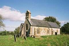 Church of St Michael, Cudworth |
|
 Cudworth |
|
| Population | 69 (2011)[1] |
|---|---|
| OS grid reference | ST375105 |
| Civil parish | Chard |
| District | South Somerset |
| Shire county | Somerset |
| Region | South West |
| Country | England |
| Sovereign state | United Kingdom |
| Post town | Ilminster |
| Postcode district | TA19 0 |
| Dialling code | 01460 |
| Police | Avon and Somerset |
| Fire | Devon and Somerset |
| Ambulance | South Western |
| EU Parliament | South West England |
| UK Parliament | Yeovil |
Coordinates: 50°53′26″N 2°53′24″W / 50.8905°N 2.8899°W
Cudworth is a village and parish in Somerset, England, situated 5 miles (8.0 km) north east of Chard in the South Somerset district. The village has a population of 69.[1]
History
The parish of Cudworth was part of the South Petherton Hundred.[2]
The manor was held, around 1187, by Alan de Furneaux who gave the church and 30 acres (12.1 ha) of land to Wells Cathedral to found the Cudworth prebend. The Speke family had the lordship from 1431 to 1791 when it was bought by the Pouletts of Hinton St George.[3]
300 m east of Knight House Farm are earthworks showing the site of houses, tracks and farming from a medieval settlement.[4]
Governance
The parish council has responsibility for local issues, including setting an annual precept (local rate) to cover the council’s operating costs and producing annual accounts for public scrutiny. The parish council evaluates local planning applications and works with the local police, district council officers, and neighbourhood watch groups on matters of crime, security, and traffic. The parish council's role also includes initiating projects for the maintenance and repair of parish facilities, as well as consulting with the district council on the maintenance, repair, and improvement of highways, drainage, footpaths, public transport, and street cleaning. Conservation matters (including trees and listed buildings) and environmental issues are also the responsibility of the council.
The village falls within the Non-metropolitan district of South Somerset, which was formed on 1 April 1974 under the Local Government Act 1972, having previously been part of Chard Rural District.[5] The district council is responsible for local planning and building control, local roads, council housing, environmental health, markets and fairs, refuse collection and recycling, cemeteries and crematoria, leisure services, parks, and tourism.
Somerset County Council is responsible for running the largest and most expensive local services such as education, social services, libraries, main roads, public transport, policing and fire services, trading standards, waste disposal and strategic planning.
It is also part of the Yeovil county constituency represented in the House of Commons of the Parliament of the United Kingdom. It elects one Member of Parliament (MP) by the first past the post system of election, and part of the South West England constituency of the European Parliament which elects seven MEPs using the d'Hondt method of party-list proportional representation.
Religious sites
The Anglican parish Church of St Michael has 12th-century origins, with the north doorway and one small window of that period remaining. The nave and chancel are from the 13th century.[6] The Old Prebendal House was built as a vicarage in the 17th century.[7]
References
- 1 2 "South Somerset population estimates for 2002" (PDF). Somerset County Council. Archived from the original (PDF) on 21 November 2009. Retrieved 27 December 2009.
- ↑ "Somerset Hundreds". GENUKI. Retrieved 20 October 2011.
- ↑ Bush, Robin (1994). Somerset: The Complete Guide. Dovecote Press. p. 78. ISBN 1-874336-26-1.
- ↑ "Medieval settlement 300 m east of Knight House Farm". National Heritage List for England. English Heritage. Retrieved 21 November 2014.
- ↑ "Chard RD". A vision of Britain Through Time. University of Portsmouth. Retrieved 4 January 2014.
- ↑ "Church of St Michael". Images of England. English Heritage. Retrieved 2009-01-04.
- ↑ "The Old Prebendal House". Images of England. English Heritage. Retrieved 2009-01-04.
