Barton St David
| Barton St David | |
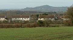 Barton St David and Glastonbury Tor |
|
 Barton St David |
|
| Population | 561 (2011)[1] |
|---|---|
| OS grid reference | ST541318 |
| Civil parish | Barton St David |
| District | South Somerset |
| Shire county | Somerset |
| Region | South West |
| Country | England |
| Sovereign state | United Kingdom |
| Post town | SOMERTON |
| Postcode district | TA11 6 |
| Dialling code | 01458 |
| Police | Avon and Somerset |
| Fire | Devon and Somerset |
| Ambulance | South Western |
| EU Parliament | South West England |
| UK Parliament | Somerton and Frome |
Coordinates: 51°05′02″N 2°39′25″W / 51.084°N 2.657°W
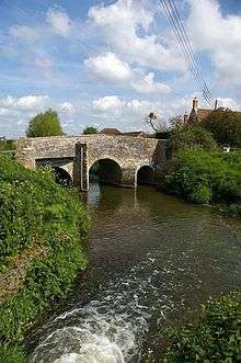
Barton St David is a village and civil parish on the River Brue adjacent to Keinton Mandeville in Somerset, England. It is situated 5 miles (8 km) south-east of Glastonbury and 5 miles (8 km) north-east of Somerton in the South Somerset district. The village has a population of 561.[1]
History
The parish was part of the hundred of Catsash.[2]
Governance
The parish council has responsibility for local issues, including setting an annual precept (local rate) to cover the council’s operating costs and producing annual accounts for public scrutiny. The parish council evaluates local planning applications and works with the local police, district council officers, and neighbourhood watch groups on matters of crime, security, and traffic. The parish council's role also includes initiating projects for the maintenance and repair of parish facilities, as well as consulting with the district council on the maintenance, repair, and improvement of highways, drainage, footpaths, public transport, and street cleaning. Conservation matters (including trees and listed buildings) and environmental issues are also the responsibility of the council.
The village falls within the Non-metropolitan district of South Somerset, which was formed on 1 April 1974 under the Local Government Act 1972, having previously been part of Langport Rural District.[3] The district council is responsible for local planning and building control, local roads, council housing, environmental health, markets and fairs, refuse collection and recycling, cemeteries and crematoria, leisure services, parks, and tourism.
Somerset County Council is responsible for running the largest and most expensive local services such as education, social services, libraries, main roads, public transport, policing and fire services, trading standards, waste disposal and strategic planning.
It is also part of the Somerton and Frome county constituency represented in the House of Commons of the Parliament of the United Kingdom. It elects one Member of Parliament (MP) by the first past the post system of election, and part of the South West England constituency of the European Parliament which elects seven MEPs using the d'Hondt method of party-list proportional representation.
Church
The Church of St David has 12th-century origins. The tower, which is octagonal, is in three stages and probably dates from the 15th century. It has been designated by English Heritage as a Grade II* listed building.[4]
Notable inhabitants
Barton St David was the birthplace of Henry Adams (1583–1646), who, after their marriage in nearby Charlton Mackrell, emigrated with his wife Edith and nine children to the new colonies in Massachusetts. He was the great-great-grandfather of John Adams, the first Vice President and second President of the United States. He was the great-great-great-grandfather of John Quincy Adams, the sixth President of the United States. There is a plaque in the parish church which commemorates this link between the village and the United States.
References
- 1 2 "Statistics for Wards, LSOAs and Parishes — SUMMARY Profiles" (Excel). Somerset Intelligence. Retrieved 4 January 2014.
- ↑ "Somerset Hundreds". GENUKI. Retrieved 8 October 2011.
- ↑ "Langport RD". A vision of Britain Through Time. University of Portsmouth. Retrieved 4 January 2014.
- ↑ "Church of St David". Images of England. English Heritage. Archived from the original on 12 October 2012. Retrieved 23 September 2008.
