Tintinhull
| Tintinhull | |
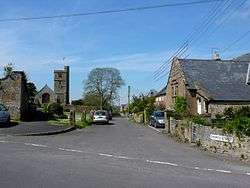 Church Street and the Church of St Margaret |
|
 Tintinhull |
|
| Population | 1,124 (2011)[1] |
|---|---|
| OS grid reference | ST497195 |
| District | South Somerset |
| Shire county | Somerset |
| Region | South West |
| Country | England |
| Sovereign state | United Kingdom |
| Post town | YEOVIL |
| Postcode district | BA22 8 |
| Dialling code | 01935 |
| Police | Avon and Somerset |
| Fire | Devon and Somerset |
| Ambulance | South Western |
| EU Parliament | South West England |
| UK Parliament | Yeovil |
Coordinates: 50°58′25″N 2°42′53″W / 50.97361°N 2.71484°W
Tintinhull is a middle sized village and civil parish close to the A303 near Yeovil, 2.5 miles (4 km) south west of Ilchester, in Somerset, England. The village is on the Fosse Way.
In addition to a school of 104 pupils, Tintinhull has a church, park, swimming pool and other amenities.
History
The village was mentioned in the Domesday Book of 1086.[2] The surrounding landscape shows evidence of 2000 years of farming.
The parish was headquarters and part of the Tintinhull Hundred.[3]
Governance
The parish council has responsibility for local issues, including setting an annual precept (local rate) to cover the council’s operating costs and producing annual accounts for public scrutiny. The parish council evaluates planning applications and works with the police, district council officers, and neighbourhood watch groups on matters of crime, security, and traffic. The council's role also includes initiating projects for the maintenance and repair of parish facilities, as well as consulting with the district council on the maintenance, repair, and improvement of highways, drainage, footpaths, public transport, and street cleaning. Conservation matters (including trees and listed buildings) and environmental issues are also the responsibility of the council.
The village falls within the non-metropolitan district of South Somerset, which was formed on 1 April 1974 under the Local Government Act 1972, having previously been part of Yeovil Rural District.[4] The district council is responsible for local planning and building control, local roads, council housing, environmental health, markets and fairs, refuse collection and recycling, cemeteries and crematoria, leisure services, parks, and tourism.
Somerset County Council is responsible for running the largest and most expensive local services such as education, social services, libraries, main roads, public transport, policing and fire services, trading standards, waste disposal and strategic planning.
It is also part of the Yeovil county constituency represented in the House of Commons of the Parliament of the United Kingdom. It elects one Member of Parliament (MP) by the first past the post system of election, and part of the South West England constituency of the European Parliament which elects seven MEPs using the d'Hondt method of party-list proportional representation.
Landmarks
Most of the buildings are of honey-coloured Ham stone. These include several 16th–, 17th- and 18th-century dwellings such as the 17th-century Tintinhull House[5] at Tintinhull Garden which is now National Trust property, and Tintinhull Court.
Religious sites
The Church of St Margaret has origins in the 13th century and has been designated by English Heritage a grade 1 listed building,[6] as has the old parsonage which is now called Tintinhull Court.[7]
References
- ↑ "Statistics for Wards, LSOAs and Parishes — SUMMARY Profiles" (Excel). Somerset Intelligence. Retrieved 4 January 2014.
- ↑ "Normans". Tintinhull Local History Group. Retrieved 2008-08-06.
- ↑ "Somerset Hundreds". GENUKI. Retrieved 22 October 2011.
- ↑ "Yeovil RD". A vision of Britain Through Time. University of Portsmouth. Retrieved 4 January 2014.
- ↑ "Tintinhull House". Images of England. Retrieved 2008-03-17.
- ↑ "Church of St Margaret". Images of England. Retrieved 2008-03-17.
- ↑ "Tintinhull Court". Images of England. Retrieved 2008-03-17.
External links
| Wikimedia Commons has media related to Tintinhull. |
