East Chinnock
| East Chinnock | |
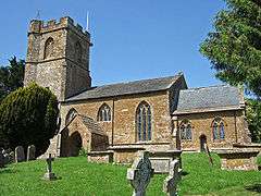 The Church of Saint Mary in East Chinnock |
|
 East Chinnock |
|
| Population | 479 (2011)[1] |
|---|---|
| OS grid reference | ST495135 |
| District | South Somerset |
| Shire county | Somerset |
| Region | South West |
| Country | England |
| Sovereign state | United Kingdom |
| Post town | YEOVIL |
| Postcode district | BA22 9 |
| Dialling code | 01935 |
| Police | Avon and Somerset |
| Fire | Devon and Somerset |
| Ambulance | South Western |
| EU Parliament | South West England |
| UK Parliament | Yeovil |
Coordinates: 50°55′07″N 2°43′11″W / 50.9187°N 2.7197°W
East Chinnock is a village and civil parish in Somerset, England, situated on the A30 road 4 miles (6.4 km) south west of Yeovil in the South Somerset district. The parish has a population of 479 (2011 census).[1]
History
.jpg)
The origin of the name Chinnock is uncertain. It may be derived from the Old English cinu meaning ravine or cinn meaning a chin shaped hill, with the addition of ock meaning little.[3] An alternative derivation may be an old hill-name of Celtic origin.[4]
The Chinnocks were held as one estate in Saxon times by Wynflaed under Shaftesbury Abbey but by the time of the Norman Conquest in 1066 East Chinnock was a separate estate. It was granted to Robert, Count of Mortain and his son William gave it to Montacute Priory who held it until the dissolution of the monasteries in 1539, when it was bought by the Portmans of Orchard Portman.[3]
Governance
The parish council has responsibility for local issues, including setting an annual precept (local rate) to cover the council’s operating costs and producing annual accounts for public scrutiny. The parish council evaluates local planning applications and works with the local police, district council officers, and neighbourhood watch groups on matters of crime, security, and traffic. The parish council's role also includes initiating projects for the maintenance and repair of parish facilities, as well as consulting with the district council on the maintenance, repair, and improvement of highways, drainage, footpaths, public transport, and street cleaning. Conservation matters (including trees and listed buildings) and environmental issues are also the responsibility of the council.
The village falls within the Non-metropolitan district of South Somerset, which was formed on 1 April 1974 under the Local Government Act 1972, having previously been part of Yeovil Rural District.[5] The district council is responsible for local planning and building control, local roads, council housing, environmental health, markets and fairs, refuse collection and recycling, cemeteries and crematoria, leisure services, parks, and tourism.
Somerset County Council is responsible for running the largest and most expensive local services such as education, social services, libraries, main roads, public transport, policing and fire services, trading standards, waste disposal and strategic planning.
It is also part of the Yeovil county constituency represented in the House of Commons of the Parliament of the United Kingdom. It elects one Member of Parliament (MP) by the first past the post system of election, and part of the South West England constituency of the European Parliament which elects seven MEPs using the d'Hondt method of party-list proportional representation.
Landmarks
Weston House in East Chinnock dates from 1637.[6]
To the west of the village is an unusual salt spring, locally known as Salt Hole. It was used for salt manufacture until the mid 19th century.[7]
Religious sites
The Church of Saint Mary in East Chinnock has 14th-century origins.[8] Most of the stained glass windows of the nave and chancel were made by Gunther Anton, who had been a prisoner of war in Yeovil during World War II, and dedicated by George Carey in 1989.[3]
The ecclesiastical parish is now part of the Benefice of West Coker with Hardington Mandeville, East Chinnock and Pendomer.[9]
References
- 1 2 "Statistics for Wards, LSOAs and Parishes — SUMMARY Profiles" (Excel). Somerset Intelligence. Retrieved 4 January 2014.
- ↑ Charter S 1539 at the Electronic Sawyer
- 1 2 3 Bush, Robin (1994). Somerset: The Complete Guide. Dovecote Press. p. 91. ISBN 1-874336-26-1.
- ↑ Mills, A.D.; Room, A. (2003). A Dictionary of British Place-Names. Oxford: Oxford University Press. Chinnock. ISBN 0-19-852758-6.
- ↑ "Yeovil RD". A vision of Britain Through Time. University of Portsmouth. Retrieved 4 January 2014.
- ↑ "Weston House". Images of England. English Heritage. Retrieved 2009-02-08.
- ↑ Village website: The Famous Salt Spring
- ↑ "Church of Saint Mary, East Chinnock". Images of England. English Heritage. Retrieved 2009-02-08.
- ↑ Diocese of Bath and Wells website
External links
![]() Media related to East Chinnock at Wikimedia Commons
Media related to East Chinnock at Wikimedia Commons
